Current Weather/Notams (Metars, TAFs, Notams, NWS Forecast, PIREPS, and nearby weather)
Customs Information Send updates to Support@FltPlan.com
Customs Not Available
Database effective 04/18/2024
Airport Diagram might not be current.
|
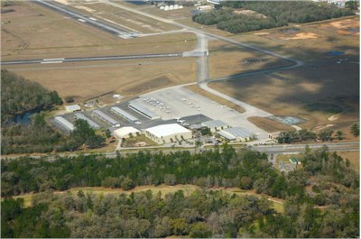
| Facility Name: | BROOKSVILLE-TAMPA BAY RGNL |
| City Name: | BROOKSVILLE |
| County: | HERNANDO |
| State abbrev: | FL |
| State Name: | FLORIDA |
| | |
| Ownership: | PUBLICLY OWNED |
| Use: | OPEN TO THE PUBLIC |
| Owner's Name: | HERNANDO COUNTY BOCC |
| Address: | 20 NORTH MAIN STREET, ROOM 263, M 263 |
| | BROOKSVILLE, FL 34601 |
| Owner's Phone: | 352-754-4000 |
| | |
| Manager's Name: | STEVE MILLER |
| Address: | 15800 FLIGHT PATH DR |
| | BROOKSVILLE, FL 34604 |
| Phone: | 352-540-6342 |
| | |
| FAA Region: | SOUTHERN |
| FAA Field Office: | ORL |
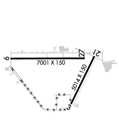
Runway Identifications
Runway Identification: 03/21Length: 5014 ft
Width: 150 ft
Surface: CONCRETE-GOOD CONDITION
Edge lights: Medium IntensityTreatment: NONE
Weight: PCN 26 /R/C/W/T
| | Runway: 03 | | Runway: 21 |
| Mag heading: | 30° | Mag heading: | 210° |
| Rwy Slope: | .01% Up | Rwy Slope: | -.01% Down |
| Approach: | | Approach: | |
| Pattern: | Left Traffic | Pattern: | Left Traffic |
| Markings: | NONPRECISION INSTRUMENT | Markings: | NONPRECISION INSTRUMENT |
| Marking Condition: | GOOD | Marking Condition: | GOOD |
| Arresting Dev: | | Arresting Dev: | |
| Lat & Long: | N2827.8 W08227.2 | Lat. & Long.: | N2828.6 W08226.8 |
| Elev: | 67.5 ft. MSL | Elev: | 68.0 ft. MSL |
| TCH: | 40 ft. AGL | TCH: | 39 ft. AGL |
| Visual Glide Path: | 3.00 degrees | Visual Glide Path: | 3.00 degrees |
| Displaced Threshold: | No | Displaced Threshold: | No |
| Touchdown Zone: | YES | Touchdown Zone: | YES |
| Touchdown Elev.: | 67.9 feet | Touchdown Elev.: | 69.1 feet |
| Visual Glide Slope: | 4-Light PAPI on LEFT side of Runway | Visual Glide Slope: | 4-Light PAPI on LEFT side of Runway |
| RVR Equipment: | | RVR Equipment: | |
| RVV Equipment: | NO | RVV Equipment: | NO |
| Approach Lights: | | Approach Lights: | |
| REIL: | NO | REIL: | NO |
| Centerline Lights: | NO | Centerline Lights: | NO |
| Touchdown lights: | NO | Touchdown lights: | NO |
| Runway Category: | Runway with a Non-precision Approach having visibility minimums greater than 3/4 mile | Runway Category: | Runway with a Non-precision Approach having visibility minimums greater than 3/4 mile |
| Declared Distances: | | Declared Distances: | |
| Obstructions: | TREES | Obstructions: | TREES |
| Marked: | NOT Marked/Lighted | Marked: | NOT Marked/Lighted |
| Clearance slope: | 25:1 | Clearance slope: | 34:1 |
| Obstruction height: | 36 feet AGL | Obstruction height: | 81 feet AGL |
| Dist. from runway: | 1095 feet | Dist. from runway: | 2960 feet |
| Centerline offset: | 250 left of centerline | Centerline offset: | |
| Comments: | | Comments: | |
Runway Identification: 09/27Length: 7001 ft
Width: 150 ft
Surface: ASPHALT
Edge lights: Medium IntensityTreatment: GROOVED
Weight: PCN 29 /R/C/W/T
| | Runway: 09 | | Runway: 27 |
| Mag heading: | 94° | Mag heading: | 274° |
| Rwy Slope: | -.01% Down | Rwy Slope: | .01% Up |
| Approach: | ILS/DME | Approach: | |
| Pattern: | Left Traffic | Pattern: | Left Traffic |
| Markings: | PRECISION INSTRUMENT | Markings: | NONPRECISION INSTRUMENT |
| Marking Condition: | GOOD | Marking Condition: | GOOD |
| Arresting Dev: | | Arresting Dev: | |
| Lat & Long: | N2828.6 W08228.2 | Lat. & Long.: | N2828.6 W08226.9 |
| Elev: | 70.1 ft. MSL | Elev: | 69.1 ft. MSL |
| TCH: | 58 ft. AGL | TCH: | 57 ft. AGL |
| Visual Glide Path: | 3.00 degrees | Visual Glide Path: | 3.00 degrees |
| Displaced Threshold: | No | Displaced Threshold: | No |
| Touchdown Zone: | YES | Touchdown Zone: | YES |
| Touchdown Elev.: | 76.0 feet | Touchdown Elev.: | 69.1 feet |
| Visual Glide Slope: | 4-Light PAPI on LEFT side of Runway | Visual Glide Slope: | 4-Light PAPI on LEFT side of Runway |
| RVR Equipment: | | RVR Equipment: | |
| RVV Equipment: | NO | RVV Equipment: | NO |
| Approach Lights: | MALSR - 1,400 foot medium intensity approach lighting system with runway alignment indicator lights | Approach Lights: | |
| REIL: | NO | REIL: | NO |
| Centerline Lights: | NO | Centerline Lights: | NO |
| Touchdown lights: | NO | Touchdown lights: | NO |
| Runway Category: | Precision Instrument Runway | Runway Category: | Runway with a Non-precision Approach having visibility minimums greater than 3/4 mile |
| Declared Distances: | | Declared Distances: | |
| Obstructions: | TREES | Obstructions: | TREES |
| Marked: | NOT Marked/Lighted | Marked: | NOT Marked/Lighted |
| Clearance slope: | 44:1 | Clearance slope: | 34:1 |
| Obstruction height: | 70 feet AGL | Obstruction height: | 99 feet AGL |
| Dist. from runway: | 3280 feet | Dist. from runway: | 3540 feet |
| Centerline offset: | 360 right of centerline | Centerline offset: | 75 feet right of centerline |
| Comments: | | Comments: | |