Current Weather/Notams (Metars, TAFs, Notams, NWS Forecast, PIREPS, and nearby weather)
Customs Information Send updates to Support@FltPlan.com
Customs Not Available
Database effective 05/16/2024
Airport Diagram might not be current.
|
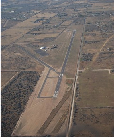
| Facility Name: | BROOKS COUNTY |
| City Name: | FALFURRIAS |
| County: | BROOKS |
| State abbrev: | TX |
| State Name: | TEXAS |
| | |
| Ownership: | PUBLICLY OWNED |
| Use: | OPEN TO THE PUBLIC |
| Owner's Name: | BROOKS COUNTY |
| Address: | CO COMMISSIONERS COURT |
| | FALFURRIAS, TX 78355 |
| Owner's Phone: | 361-325-5604 |
| | |
| Manager's Name: | BOND COSBY |
| Address: | PO BOX 556 |
| | FALFURRIAS, TX 78355 |
| Phone: | 361-325-2909; 361-850-3430 OR FROM NOV-FEB ON CALL 24/7 |
| | |
| FAA Region: | SOUTHWEST |
| FAA Field Office: | TEX |
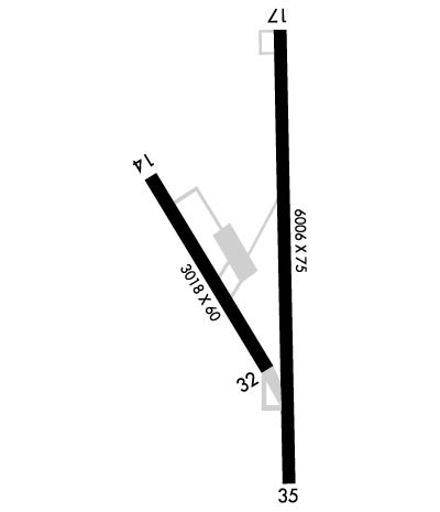
Runway Identifications
Runway Identification: 14/32Length: 3018 ft
Width: 60 ft
Surface: ASPHALT
Edge lights: Treatment: NONE
| | Runway: 14 | | Runway: 32 |
| Mag heading: | 143° | Mag heading: | 323° |
| Rwy Slope: | .00% | Rwy Slope: | .00% |
| Approach: | | Approach: | |
| Pattern: | Left Traffic | Pattern: | Left Traffic |
| Markings: | NONPRECISION INSTRUMENT | Markings: | NONPRECISION INSTRUMENT |
| Marking Condition: | GOOD | Marking Condition: | GOOD |
| Arresting Dev: | | Arresting Dev: | |
| Lat & Long: | N2712.5 W09807.5 | Lat. & Long.: | N2712.1 W09807.2 |
| Elev: | 110.8 ft. MSL | Elev: | 110.8 ft. MSL |
| TCH: | | TCH: | |
| Visual Glide Path: | | Visual Glide Path: | |
| Displaced Threshold: | No | Displaced Threshold: | No |
| Touchdown Zone: | YES | Touchdown Zone: | YES |
| Touchdown Elev.: | 110.8 feet | Touchdown Elev.: | 110.8 feet |
| Visual Glide Slope: | | Visual Glide Slope: | |
| RVR Equipment: | | RVR Equipment: | |
| RVV Equipment: | NO | RVV Equipment: | NO |
| Approach Lights: | | Approach Lights: | |
| REIL: | NO | REIL: | NO |
| Centerline Lights: | NO | Centerline Lights: | NO |
| Touchdown lights: | NO | Touchdown lights: | NO |
| Runway Category: | Runway with a Visual Approach | Runway Category: | Runway with a Visual Approach |
| Declared Distances: | | Declared Distances: | |
| Obstructions: | TREES | Obstructions: | |
| Marked: | NOT Marked/Lighted | Marked: | |
| Clearance slope: | 8:1 | Clearance slope: | 20:1 |
| Obstruction height: | 20 feet AGL | Obstruction height: | |
| Dist. from runway: | 360 feet | Dist. from runway: | |
| Centerline offset: | 125 left of centerline | Centerline offset: | |
| Comments: | | Comments: | |
Runway Identification: 17/35Length: 6006 ft
Width: 75 ft
Surface: ASPHALT-GOOD CONDITION
Edge lights: Medium IntensityTreatment: NONE
| | Runway: 17 | | Runway: 35 |
| Mag heading: | 174° | Mag heading: | 354° |
| Rwy Slope: | -.01% Down | Rwy Slope: | .01% Up |
| Approach: | | Approach: | |
| Pattern: | Left Traffic | Pattern: | Left Traffic |
| Markings: | NONPRECISION INSTRUMENT | Markings: | NONPRECISION INSTRUMENT |
| Marking Condition: | GOOD | Marking Condition: | GOOD |
| Arresting Dev: | | Arresting Dev: | |
| Lat & Long: | N2712.9 W09807.2 | Lat. & Long.: | N2711.9 W09807.2 |
| Elev: | 111.4 ft. MSL | Elev: | 110.7 ft. MSL |
| TCH: | 45 ft. AGL | TCH: | 45 ft. AGL |
| Visual Glide Path: | 3.00 degrees | Visual Glide Path: | 3.00 degrees |
| Displaced Threshold: | No | Displaced Threshold: | No |
| Touchdown Zone: | YES | Touchdown Zone: | YES |
| Touchdown Elev.: | 111.4 feet | Touchdown Elev.: | 111.7 feet |
| Visual Glide Slope: | 4-Light PAPI on LEFT side of Runway | Visual Glide Slope: | 4-Light PAPI on LEFT side of Runway |
| RVR Equipment: | | RVR Equipment: | |
| RVV Equipment: | NO | RVV Equipment: | NO |
| Approach Lights: | | Approach Lights: | |
| REIL: | YES | REIL: | NO |
| Centerline Lights: | NO | Centerline Lights: | NO |
| Touchdown lights: | NO | Touchdown lights: | NO |
| Runway Category: | Runway with a Non-precision Approach having visibility minimums greater than 3/4 mile | Runway Category: | Runway with a Non-precision Approach having visibility minimums greater than 3/4 mile |
| Declared Distances: | | Declared Distances: | |
| Obstructions: | TREE | Obstructions: | |
| Marked: | NOT Marked/Lighted | Marked: | |
| Clearance slope: | 26:1 | Clearance slope: | 50:1 |
| Obstruction height: | 31 feet AGL | Obstruction height: | |
| Dist. from runway: | 1020 feet | Dist. from runway: | |
| Centerline offset: | | Centerline offset: | |
| Comments: | | Comments: | |