OPERATIONAL (This Status can change at any time - please check NOTAMS)
Airport Lighting Schedule
WHEN ATCT CLSD ACTVT MALSF RWY 24R; REIL RWY 06L - CTAF. HIRL RWY 06L/24R PRESET MED INTST, TO INCR INTST RDO REQ ON UNICOM. PAPI RWY 06L & 24R OPR CONSLY.
Airport Storage Available
Tie Downs, Hanger
Extra Services Available
Air Freight, Air Ambulance, Avionics, Cargo Handling, Charter, Flight Instruction
Wind Indicator
YES - (lighted)
Control Tower
YES
CTAF Frequency
124.300
Unicom Frequency
122.950
Rotating Beacon Color
WG
Segmented Circle
Y-L
Landing Fee
YES; FEE SKED BASED ON NR OF ENGINES AND GWT.
Airport Inspection Data
Airport Inspected
FEDERAL - performed by FAA AIRPORTS FIELD PERSONNEL
Inspection Date
09/05/2023
Airport Services
Type of Fuel Available
Grade 100LL, JET A (freeze point -40C)
Airframe Repair Service
MAJOR
Power Plant Repair Service
MAJOR
Geographic Data
Latitude
N4131.1
Longitude
W08141.0 (ESTIMATED)
Arpt Elevation
583ft (SURVEYED)
Magnetic Variation
07W
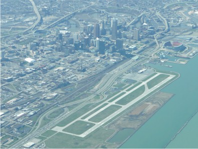
1 miles N
of CLEVELAND
Traffic Pattern Altitude
Sectional Chart
DETROIT
Aircraft Data
Operations (Reported)
Yearly
Avg. Daily
General Aviation Transient
13258
36
General Aviation Local
29391
81
Air Taxi
9682
27
Commerical
97
0
Commuter
0
0
Military
449
1
Aircraft based on Field
General Aviation Singles
8
General Aviation Multi
0
Jet Aircraft
4
General Aviation Helicopters
5
Military Aircraft
0
Gliders
0
Ultralights
0
FAA Services
FSS on field
NO
FSS tie-in
CLEVELAND
FSS Phone
1-800-WX-BRIEF
Who issues Notams
BKL
Notam D service at airport
YES
ARTCC Name
CLEVELAND
Federal Status
Airport Certification
CLSD TO SKEDD ACR OPS GTR THAN 9 PAX SEATS. PPR FOR UNSKED ACR OPS WITH MORE THAN 30 PAX SEATS CALL AMGR.
Aircraft Rescue & Firefighting Index
AIRPORT HAS A CERTIFICATE UNDER CFR PART 139
Airport of Entry
No
Custom Landing Rights
No
Joint Civil/Military
No
Military Landing rights
YES
Federal Agreements
NATIONAL PLAN OF INTEGRATED AIRPORT SYSTEMS (NPIAS)
GRANT AGREEMENTS UNDER FAAP/ADAP/AIP
ASSURANCES PURSUANT TO TITLE VI, CIVIL RIGHTS ACT OF 1964
Remarks
BIRDS AND WATERFOWL ON & INVOF ARPT.
FLIGHT NOTIFICATION SERVICE (ADCUS) AVBL 24 HRS MON-FRI REQ FOR SERVICE ON SAT; SUN & HOLS MUST BE MADE PRIOR TO 1630 ON FRI; 2 HRS ADVANCE NOTICE REQUIRED CALL 216-267-3600. PRIVATE ACFT & GENERAL AVIATION ONLY.
72 FT SHIP CRANE 1300 FT SW OF RWY 06R.
FOR CD WHEN ATCT CLSD CTC CLEVELAND APCH AT 216-352-2323.
RWY 06R/ 24LCLSD TO UNSKED ACR OPS GTR THAN 30 PAX SEATS; CLSD WHEN ATCT CLSD.
Airport Communications & Frequencies:
ATIS Frequencies: Hours(local) of Operation: CONTINUOUS
125.25
LAKEFRONT Tower Frequencies: Hours(local) of operation: 0700 MON TO 2300 FRI; 0700-2300 SAT; SUN 0800-0000
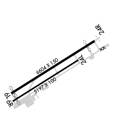
Length: 6604 ft Width: 150 ft Surface: ASPHALT-GOOD CONDITION Edge lights: High Intensity Treatment: GROOVED Weight: PCN 84 /F/C/X/T
Runway: 06L
Runway: 24R
Mag heading:
65°
Mag heading:
245°
Rwy Slope:
.02% Up
Rwy Slope:
-.02% Down
Approach:
Approach:
ILS/DME
Pattern:
Left Traffic
Pattern:
Right Traffic
Markings:
PRECISION INSTRUMENT
Markings:
PRECISION INSTRUMENT
Marking Condition:
GOOD
Marking Condition:
GOOD
Arresting Dev:
Arresting Dev:
EMAS
Lat & Long:
N4130.8 W08141.5
Lat. & Long.:
N4131.4 W08140.3
Elev:
581.1 ft. MSL
Elev:
582.4 ft. MSL
TCH:
45 ft. AGL
TCH:
42 ft. AGL
Visual Glide Path:
3.00 degrees
Visual Glide Path:
3.00 degrees
Displaced Threshold:
178 feet
Displaced Threshold:
600 feet
Touchdown Zone:
YES
Touchdown Zone:
YES
Touchdown Elev.:
582.8 feet
Touchdown Elev.:
583.0 feet
Visual Glide Slope:
4-Light PAPI on RIGHT side of Runway; UNUSBL BYD 5 DEGS RIGHT OF CNTRLN.
Visual Glide Slope:
4-Light PAPI on RIGHT side of Runway; UNUSBL BYD 8 DEGS LEFT OF CRS.
RVR Equipment:
RVR Equipment:
RVV Equipment:
NO
RVV Equipment:
NO
Approach Lights:
Approach Lights:
MALSF - 1,400 foot medium intensity approach lighting system with sequenced flashers
REIL:
YES
REIL:
NO
Centerline Lights:
NO
Centerline Lights:
NO
Touchdown lights:
NO
Touchdown lights:
NO
Runway Category:
Runway with a Visual Approach
Runway Category:
Precision Instrument Runway
Declared Distances:
TORA:6503' TODA:6503' ASDA:6503' LDA:6325'
Declared Distances:
TORA:6603' TODA:6603' ASDA:6603' LDA:6003'
Obstructions:
RWY 06L/24R & RWY 06R/24L APCH SFCS HAVE NAVIGABLE WATERWAYS CREATING POSSIBLE VESSEL OBSTRUCTION AREAS - CHECK LOCAL NOTAMS FOR CURRENT ACTIVITY; VESSEL HEIGHT; ETC.
Obstructions:
BLDG
Marked:
NOT Marked/Lighted
Marked:
NOT Marked/Lighted
Clearance slope:
50:1
Clearance slope:
25:1
Obstruction height:
Obstruction height:
122 feet AGL
Dist. from runway:
Dist. from runway:
3364 feet
Centerline offset:
Centerline offset:
837 feet left of centerline
Comments:
Comments:
Runway Identification: 06R/24L
Length: 5197 ft Width: 100 ft Surface: ASPHALT-GOOD CONDITION Edge lights: High Intensity Treatment: GROOVED Weight: PCN 63 /F/C/X/T