Click here for more info on on SMS!

KBJC

ROCKY MOUNTAIN METROPOLITAN
DENVER
CO
Time Zone: Mountain
Lat: N 3954.5
Long: W 10507.0
Elev: 5673
Var: -09
Longest Runway: 9000
Clr Del: 132.6
Dept. ATIS: 126.25
Arr. ATIS: 126.25
Ground: 121.7
Tower: 118.6

FBO & Flight Services info for KBJC

FBOs: Update your Fuel Prices
Welcome to Signature Aviation, where uniting exceptional customer service and uncompromising safety standards is our primary focus.
Ph: 303-466-2336 Fax: 303-466-1524 Freq: 131.57WebsiteE-Mail
                          
Service
Jet
100LL
SAF
MoGas
Fuel Avail: PRIST+ $0.09. PLEASE CALL 800.525.8139 FOR BEST FUEL DISCOUNT!
Full7.757.50    Last Update: 04/25/2024 09:46

TYPE 4 & TYPE 1 ANTI-ICE & DE-ICE AVAILABLE
Self  6.10    
Misc. Info: CLOSEST FBO TO DOWNTOWN DENVER!Address: 11705 AIRPORT WAY   BROOMFIELD, CO 80021

  click here  
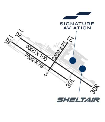
Sheltair - KBJC is conveniently located at the foot of the Rocky Mountains for optimum ski resort repositioning & quick access to the downtown business districts. Services include: Deicing, superior ground support and concierge services, canteen market and complimentary refreshments, pilot lounge and flight planning room, crew cars and on-site rentals, complimentary interior cleaning.
Ph: 303-590-9654 Fax: 303-469-3595 Freq: 131.47WebsiteE-Mail
                     
Service
Jet
100LL
SAF
MoGas
Fuel Avail: Jet A with Prist is + $0.10/gal.
Full7.867.78    Last Update: 04/13/2024 18:02

Self        
Misc. Info: Address: 9107 ROCKY ROAD   BROOMFIELD, CO 80021

DUNCAN AVIONICSPh: 303-410-7053 Fax: 303-410-7058 Freq: 122.95

AWOSPh: 720-887-8067
-
Freq: 126.25  
ATISPh: 303-466-8744
-
Freq: 126.25  
If you are an FBO, call 1-203-262-1700 to update your info or email: FltPlan.Advertising@garmin.com
Advertise your FBO on FltPlan.com

Runway & Approach Info for KBJC
Rwy
Length
Land Dist**
Approach*
  Rwy
Length
Land Dist**
Approach*
03
3600x75  3600'          
 
  
21
  3600x75  3600'          
 
12L
9000x100  9000'          
 
  
30R
  9000x100  9000'          
ILS
 111.70 - 295°  
12R
7002x75  7002'          
 
  
30L
  7002x75  7002'          
 
 * only ILS, LOC, LDA, and SDF approaches to a specific runway are shown
** For any Declared Landing Distance Available, please see A/FD or Approach plates
Runway Weight Capability (lbs.) Help
Runway IDSingle WheelDouble WheelDouble Tandem WheelDual Double Wheel
03/2140,00045,00065,000N/A
12L/30R65,000105,000150,000N/A
12R/30L47,00061,000N/AN/A
These numbers are Advisory and are not limits.   The Airport Manager should have more accurate Weight Limits
Approach Charts
Approaches    
Current Weather/Notams
Customs Information Send updates to Support@FltPlan.com
Phone 303-271-4884
Fax 303-271-4875

Comments 2 hrs advance notice required during 0800-1630 Monday-Friday *Maximum passengers per flight: 15 *24 hours on-call. Prior arrangements required.
Database effective 05/16/2024
Airport Diagram of KBJC
Airport Diagram might not be current.

Facility Name: ROCKY MOUNTAIN METRO
City Name: DENVER
County: JEFFERSON
State abbrev: CO
State Name: COLORADO
   
Ownership: PUBLICLY OWNED
Use: OPEN TO THE PUBLIC
Owner's Name: JEFFERSON COUNTY
Address: 100 JEFFERSON CO PKWY
 GOLDEN, CO 80419
Owner's Phone: (303) 271-4850
  
Manager's Name: PAUL ANSLOW
Address: 11755 AIRPORT WAY
 BROOMFIELD, CO 80021
Phone: (303) 271-4851
   
FAA Region: NORTHWEST MOUNTAIN
FAA Field Office: DEN


Sunrise / Sunset times for ROCKY MOUNTAIN METRO

DateSunriseSunset
04/25/24 Thursday6:0719:50
04/26/24 Friday6:0619:51
04/27/24 Saturday6:0519:52
04/28/24 Sunday6:0319:53
04/29/24 Monday6:0219:54
04/30/24 Tuesday6:0119:55
05/01/24 Wednesday6:0019:56
05/02/24 Thursday5:5819:57
05/03/24 Friday5:5719:58
05/04/24 Saturday5:5619:59
05/05/24 Sunday5:5520:00
05/06/24 Monday5:5420:01
05/07/24 Tuesday5:5320:02
05/08/24 Wednesday5:5220:03

Airport Facilities

Airport Attendance ScheduleCONTINUOUS
Airport Status OPERATIONAL (This Status can change at any time - please check NOTAMS)
Airport Lighting ScheduleWHEN ATCT CLSD ACTVT MALSR RWY 30R; REIL RWY 12L, 12R & 30L; PAPI RWY 03, 12L, 12R, 21, 30L & 30R; MIRL RWY 03/21 & 12R/30L; HIRL RWY 12L/30R - CTAF.
Airport Storage AvailableTie Downs, Hanger
Extra Services AvailableAir Freight, Avionics, Cargo Handling, Charter, Flight Instruction, Aircraft Rental, Aircraft Sales, Annual Surveying
Wind IndicatorYES - (lighted)
Control TowerYES
CTAF Frequency118.600
Unicom Frequency
Rotating Beacon ColorWG
Segmented CircleYES
Landing FeeNO

Airport Inspection Data

Airport InspectedSTATE - performed by FAA AIRPORTS FIELD PERSONNEL
Inspection Date02/28/2024

Airport Services

Type of Fuel AvailableGrade 100LL, JET A (freeze point -40C); -10100LL SELF SVC.
Airframe Repair ServiceMAJOR
Power Plant Repair ServiceMAJOR

Geographic Data

LatitudeN3954.5
LongitudeW10507.0 (ESTIMATED)
Arpt Elevation5673ft (SURVEYED)
Magnetic Variation09E
9 miles NWof DENVER
Traffic Pattern Altitude
Sectional ChartDENVER

Aircraft Data

Operations (Reported)YearlyAvg. Daily
General Aviation Transient 100504275
General Aviation Local 155178425
Air Taxi 2309363
Commerical 510
Commuter 00
Military 29808
Aircraft based on Field
General Aviation Singles 341
General Aviation Multi 70
Jet Aircraft 43
General Aviation Helicopters 21
Military Aircraft 0
Gliders 0
Ultralights 1

FAA Services

FSS on field NO
FSS tie-in DENVER
FSS Phone 1-800-WX-BRIEF
Who issues Notams BJC
Notam D service at airport YES
ARTCC Name DENVER

Federal Status

Airport CertificationAIRPORT RECEIVING SCHEDULED AIR CARRIER SERVICE FROM CARRIERS CERTIFICATED BY THE CIVIL AERONAUTICS BOARD; 24 HR PPR FOR UNSKED ACR OPS WITH MORE THAN 30 PAX SEATS - 720-352-0395.
Aircraft Rescue & Firefighting IndexAIRPORT HAS A CERTIFICATE UNDER CFR PART 139
Airport of EntryNo
Custom Landing RightsNo; US CUSTOMS USER FEE ARPT.
Joint Civil/MilitaryNo
Military Landing rightsNo

Federal Agreements

NATIONAL PLAN OF INTEGRATED AIRPORT SYSTEMS (NPIAS)
GRANT AGREEMENTS UNDER FAAP/ADAP/AIP
ASSURANCES PURSUANT TO TITLE VI, CIVIL RIGHTS ACT OF 1964

Remarks

THIS AIRPORT HAS BEEN SURVEYED BY THE NATIONAL GEODETIC SURVEY.
BIRDS & WILDLIFE ON & INVOF RWY.
TWY C1 & D MKD WITH REFLECTORS.
N TRML RAMP SLP EXCEEDS RCMDD STD.
HEL ARR/DEP FM RWY & TWYS.
ARFF INDEX B AVBL PPR - 720-352-0395
PILOTS ARE REQUESTED TO AVOID FLIGHT DUE TO NESTING EAGLES: BLW 6500 FT MSL, BJC VOR 25 DEG RADIAL, 2.7 DME; OVER STANDLEY LAKE BLW 8000 FT MSL, BJC VOR 150 DEG RADIAL, 3.0 DME.
NOISE ABATEMENT PROC IN EFCT - 303-271-4850.
FLIGHT NOTIFICATION SERVICE (ADCUS) AVBL.
Airport Communications & Frequencies:
ATIS Frequencies:   Hours(local) of Operation: CONTINUOUS
126.25
METRO Tower Frequencies:   Hours(local) of operation: 0600-2200   
118.6
123.95
233.7
METRO Ground Frequencies:
121.7
Clearance Delivery Frequencies:
132.6
CTAF Frequency:
118.600
Remarks
  • FREQ 121.5 NOT AVBL.
  • DENVER Primary Approach Frequencies:  
    125.12
    263.02
    DENVER Primary Departure Frequencies:  
    125.12
    263.02
    Runway Identifications
    Runway Identification: 03/21
    Length: 3600 ft
    Width: 75 ft
    Surface: ASPHALT-FAIR CONDITION
    Edge lights: Medium Intensity

    Treatment: NONE

     Runway: 03   Runway: 21
    Mag heading: 25°Mag heading: 205°
    Rwy Slope: -.44% DownRwy Slope: .44% Up
    Approach: Approach:
    Pattern: Left TrafficPattern: Right Traffic
    Markings: BASICMarkings: BASIC
    Marking Condition: FAIRMarking Condition: FAIR
    Arresting Dev: Arresting Dev:
    Lat & Long: N3954.4  W10507.1Lat. & Long.: N3954.8  W10506.7
    Elev: 5616.0 ft. MSLElev: 5600.0 ft. MSL
    TCH: 30 ft. AGLTCH: 40 ft. AGL
    Visual Glide Path: 3.00 degreesVisual Glide Path: 3.00 degrees
    Displaced Threshold: NoDisplaced Threshold: No
    Touchdown Zone: YESTouchdown Zone: YES
    Touchdown Elev.: 5620.4 feetTouchdown Elev.: 5620.4 feet
    Visual Glide Slope: 2-Light PAPI on LEFT side of RunwayVisual Glide Slope: 2-Light PAPI on LEFT side of Runway
    RVR Equipment: RVR Equipment:
    RVV Equipment: NORVV Equipment: NO
    Approach Lights: Approach Lights:
    REIL: NOREIL: NO
    Centerline Lights: NOCenterline Lights: NO
    Touchdown lights: NOTouchdown lights: NO
    Runway Category: Runway with a Visual ApproachRunway Category: Runway with a Visual Approach
    Declared Distances: TORA:3600' TODA:3600' ASDA:3600' LDA:3600'Declared Distances: TORA:3600' TODA:3600' ASDA:3600' LDA:3600'
    Runway Identification: 12L/30R
    Length: 9000 ft
    Width: 100 ft
    Surface: ASPHALT-GOOD CONDITION
    Edge lights: High Intensity

    Treatment: GROOVED
    Weight: PCN 31 /F/D/W/T

     Runway: 12L   Runway: 30R
    Mag heading: 115°Mag heading: 295°
    Rwy Slope: -1.05% DownRwy Slope: 1.05% Up
    Approach: Approach: ILS
    Pattern: Left TrafficPattern: Right Traffic
    Markings: PRECISION INSTRUMENTMarkings: PRECISION INSTRUMENT
    Marking Condition: FAIRMarking Condition: FAIR
    Arresting Dev: Arresting Dev:
    Lat & Long: N3954.9  W10507.7Lat. & Long.: N3954.1  W10506.1
    Elev: 5660.5 ft. MSLElev: 5565.9 ft. MSL
    TCH: 41 ft. AGLTCH: 52 ft. AGL
    Visual Glide Path: 3.00 degreesVisual Glide Path: 3.00 degrees
    Displaced Threshold: NoDisplaced Threshold: No
    Touchdown Zone: YESTouchdown Zone: YES
    Touchdown Elev.: 5660.6 feetTouchdown Elev.: 5598.5 feet
    Visual Glide Slope: 4-Light PAPI on LEFT side of RunwayVisual Glide Slope: 4-Light PAPI on LEFT side of Runway
    RVR Equipment: RVR Equipment:
    RVV Equipment: NORVV Equipment: NO
    Approach Lights: Approach Lights: MALSR - 1,400 foot medium intensity approach lighting system with runway alignment indicator lights
    REIL: YESREIL: NO
    Centerline Lights: NOCenterline Lights: NO
    Touchdown lights: NOTouchdown lights: NO
    Runway Category: Runway with a Visual ApproachRunway Category: Precision Instrument Runway
    Declared Distances: TORA:9000' TODA:9000' ASDA:9000' LDA:9000'Declared Distances: TORA:9000' TODA:9000' ASDA:9000' LDA:9000'
    Runway Identification: 12R/30L
    Length: 7002 ft
    Width: 75 ft
    Surface: ASPHALT-GOOD CONDITION
    Edge lights: Medium Intensity

    Treatment: GROOVED
    Weight: PCN 18 /F/D/X/T

     Runway: 12R   Runway: 30L
    Mag heading: 115°Mag heading: 295°
    Rwy Slope: -1.11% DownRwy Slope: 1.11% Up
    Approach: Approach:
    Pattern: Right TrafficPattern: Left Traffic
    Markings: NONPRECISION INSTRUMENTMarkings: NONPRECISION INSTRUMENT
    Marking Condition: FAIRMarking Condition: FAIR
    Arresting Dev: Arresting Dev:
    Lat & Long: N3954.9  W10507.9Lat. & Long.: N3954.2  W10506.7
    Elev: 5673.3 ft. MSLElev: 5595.4 ft. MSL
    TCH: 40 ft. AGLTCH: 41 ft. AGL
    Visual Glide Path: 3.00 degreesVisual Glide Path: 3.00 degrees
    Displaced Threshold: NoDisplaced Threshold: No
    Touchdown Zone: YESTouchdown Zone: YES
    Touchdown Elev.: 5673.4 feetTouchdown Elev.: 5628.4 feet
    Visual Glide Slope: 2-Light PAPI on LEFT side of RunwayVisual Glide Slope: 2-Light PAPI on LEFT side of Runway
    RVR Equipment: RVR Equipment:
    RVV Equipment: NORVV Equipment: NO
    Approach Lights: Approach Lights:
    REIL: YESREIL: YES
    Centerline Lights: NOCenterline Lights: NO
    Touchdown lights: NOTouchdown lights: NO
    Runway Category: Runway with a Visual ApproachRunway Category: Runway with a Non-precision Approach having visibility minimums greater than 3/4 mile
    Declared Distances: TORA:7002' TODA:7002' ASDA:7002' LDA:7002'Declared Distances: TORA:7002' TODA:7002' ASDA:7002' LDA:7002'
    C:174/P: