Click here for more info on on SMS!

KBIS

BISMARCK MUNI
BISMARCK
ND
Time Zone: Central
Lat: N 4646.4
Long: W 10044.7
Elev: 1661
Var: -07
Longest Runway: 8794
Dept. ATIS: 119.35
Arr. ATIS: 119.35
AWOS: 119.35
Ground: 121.9
Tower: 118.3

FBO & Flight Services info for KBIS

FBOs: Update your Fuel Prices

  click here  
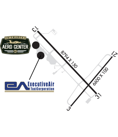
Above & Beyond Service on the ground and in the air...Whether you are in need of aircraft maintenance, rental, parts, or storage, planning an aircraft charter, or beginning your pilot training, Bismarck Aero Center will exceed your expectations with professional and customer service second to none. With Dakota Avionics, we will also meet your avionics needs!
Ph: 701-223-4754 Fax: 701-222-6508 Freq: 122.95WebsiteE-Mail
                     
Service
Jet
100LL
SAF
MoGas
Fuel Avail: 24 Hour Fuel Service PRIST+$0.05/gal
Full5.657.20    Caution: Fuel prices have not been updated in 31 days.
Last Update: 03/25/2024 16:35

Self        
Misc. Info: Discounts on Volume Fuel Purchases! Ask about how you can earn World Fuel Reward Points.Address: 2301 UNIVERSITY DR-BLDG 53   BISMARCK, ND 58504

  click here  
Lowest fuel price! Open 24/7, Quick Turns, Largest heated hangars up to G-IV, 24 hour maintenance available, Avionics, Interior shop, Charter service, De-icing, Modern Facilities, Catering, Ground handling support, Wireless internet, WSI Weather, Pilot lounge, Snooze room, Crew cars and so much more!
Ph: 701-258-5024 Fax: 701-258-2693 Freq: 122.95WebsiteE-Mail
                   
Service
Jet
100LL
SAF
MoGas
Fuel Avail: PRIST+ $0.05/gal. 24/7 FOR FSERV. No landing fees, No overnight or tiedown fees.
Full5.656.75    Last Update: 04/12/2024 07:25

WE WILL BEAT ANY CONTRACT FUEL MEMBERSHIP PRICE BY $.10 !!
Self        
Misc. Info: We beat any fuel price by $.10. Discount on volume purchases!!! Avtrip Pts! Call us at 800-932-8924.Address: 2301 UNIVERSITY DR. BLDG 48   BISMARK, ND 58504

ASOSPh: 701-255-7563
-
-
 
If you are an FBO, call 1-203-262-1700 to update your info or email: FltPlan.Advertising@garmin.com
Advertise your FBO on FltPlan.com
FBOs at nearby airports who want your business:
KFAR


  click here  
A Great Alternative to KBIS! Open 24/7, US Customs at our facility, Jet A, 100LL, competitive fuel pricing, Quick Turns, Pilots Choice Award Recipient, Recognized for Uncompromising Standards of Quality & Excellence of Service, Competitive Fuel Pricing, Quick Turns, Large Hangars up to Global/G650, Hertz on site, Avtrip Points on every gallon. www.whyfargo.com
Ph: 1-800-770-0538WebsiteE-MailFax: 1-701-237-6887Freq: 130.52

Runway & Approach Info for KBIS
Rwy
Length
Land Dist**
Approach*
  Rwy
Length
Land Dist**
Approach*
03
6600x100  6600'          
 
  
21
  6600x100  6600'          
 
13
8794x150  8794'          
ILS
 111.50 - 130°  
  
31
  8794x150  8794'          
ILS/DME
 110.30 - 310°  
 * only ILS, LOC, LDA, and SDF approaches to a specific runway are shown
** For any Declared Landing Distance Available, please see A/FD or Approach plates
Runway Weight Capability (lbs.) Help
Runway IDSingle WheelDouble WheelDouble Tandem WheelDual Double Wheel
03/21130,000180,000340,000N/A
13/31130,000180,000340,000N/A
These numbers are Advisory and are not limits.   The Airport Manager should have more accurate Weight Limits
Approach Charts
Approaches    
Current Weather/Notams
Customs Information Send updates to Support@FltPlan.com
Customs Not Available
Database effective 05/16/2024
Airport Diagram of KBIS
Airport Diagram might not be current.

Facility Name: BISMARCK MUNI
City Name: BISMARCK
County: BURLEIGH
State abbrev: ND
State Name: NORTH DAKOTA
   
Ownership: PUBLICLY OWNED
Use: OPEN TO THE PUBLIC
Owner's Name: CITY OF BISMARCK
Address: BOX 991
 BISMARCK, ND 58502
Owner's Phone: 701-355-1808
  
Manager's Name: GREGORY B HAUG; 24HR CONTACT: OPERATIONS 701-220-9885.
Address: BOX 991
 BISMARCK, ND 58502-0991
Phone: 701-355-1808
   
FAA Region: GREAT LAKES
FAA Field Office: DMA


Sunrise / Sunset times for BISMARCK MUNI

DateSunriseSunset
04/24/24 Wednesday6:3820:45
04/25/24 Thursday6:3620:46
04/26/24 Friday6:3520:47
04/27/24 Saturday6:3320:49
04/28/24 Sunday6:3120:50
04/29/24 Monday6:3020:51
04/30/24 Tuesday6:2820:53
05/01/24 Wednesday6:2720:54
05/02/24 Thursday6:2520:55
05/03/24 Friday6:2420:57
05/04/24 Saturday6:2220:58
05/05/24 Sunday6:2120:59
05/06/24 Monday6:1921:01
05/07/24 Tuesday6:1821:02

Airport Facilities

Airport Attendance ScheduleCONTINUOUS
Airport Status OPERATIONAL (This Status can change at any time - please check NOTAMS)
Airport Lighting ScheduleWHEN ATCT CLSD HIRL RYS 13/31 & 03/21 PRESET MED INTST; PAPI RYS 13; 31; 03; & 21 ON; ACTVT MALS RY 13 & MALSR RY 31 - CTAF.
Airport Storage AvailableTie Downs, Hanger
Extra Services AvailableAir Freight, Air Ambulance, Avionics, Charter, Flight Instruction, Aircraft Rental, Aircraft Sales
Wind IndicatorYES - (lighted)
Control TowerYES
CTAF Frequency118.300
Unicom Frequency122.950
Rotating Beacon ColorWG
Segmented CircleNO
Landing FeeNO

Airport Inspection Data

Airport InspectedFEDERAL - performed by FAA AIRPORTS FIELD PERSONNEL
Inspection Date09/26/2023

Airport Services

Type of Fuel AvailableGrade 100LL, JET A (freeze point -40C); -10FOR FUEL CALL 701-223-4754 OR 701-258-5024.
Airframe Repair ServiceMAJOR
Power Plant Repair ServiceMAJOR

Geographic Data

LatitudeN4646.4
LongitudeW10044.7 (ESTIMATED)
Arpt Elevation1661ft (SURVEYED)
Magnetic Variation07E
3 miles SEof BISMARCK
Traffic Pattern Altitude
Sectional ChartTWIN CITIES

Aircraft Data

Operations (Reported)YearlyAvg. Daily
General Aviation Transient 1318236
General Aviation Local 395111
Air Taxi 706819
Commerical 463713
Commuter 00
Military 20126
Aircraft based on Field
General Aviation Singles 55
General Aviation Multi 20
Jet Aircraft 13
General Aviation Helicopters 2
Military Aircraft 15
Gliders 0
Ultralights 0

FAA Services

FSS on field NO
FSS tie-in GRAND FORKS
FSS Phone 1-800-WX-BRIEF
Who issues Notams BIS
Notam D service at airport YES
ARTCC Name MINNEAPOLIS

Federal Status

Airport CertificationAIRPORT RECEIVING SCHEDULED AIR CARRIER SERVICE FROM CARRIERS CERTIFICATED BY THE CIVIL AERONAUTICS BOARD
Aircraft Rescue & Firefighting IndexAIRPORT HAS A CERTIFICATE UNDER CFR PART 139
Airport of EntryNo
Custom Landing RightsNo
Joint Civil/MilitaryNo
Military Landing rightsYES

Federal Agreements

NATIONAL PLAN OF INTEGRATED AIRPORT SYSTEMS (NPIAS)
GRANT AGREEMENTS UNDER FAAP/ADAP/AIP
SURPLUS PROPERTY AGREEMENT UNDER PUBLIC LAW 289
CONVEYANCE UNDER SCETION 16, FEDERAL AIRPORT ACT OF 1946 OR SECTION 23, AIRPORT AND AIRWAY DEVELOPMENT ACT OF 1970
ASSURANCES PURSUANT TO TITLE VI, CIVIL RIGHTS ACT OF 1964
AGREEMENT UNDER DLAND OR DCLA HAS EXPIRED.

Remarks

DEER, COYOTES & BIRDS ON & INVOF ARPT.
FOR CD IF UNA TO CTC ON FSS FREQ, CTC MINNEAPOLIS ARTCC AT 651-463-5588.
RWY 213 0Z++ MON-FRI EXC HOL, PPR 24 PN RQR DSN 373-4071/70, C701-3334071/70. FW PAX TRML LCTD IN 'SE' HGR.
RWY 03 RESA NSTD.
RWY 21 RESA NSTD.
Airport Communications & Frequencies:
ATIS Frequencies:   Hours(local) of Operation: CONTINUOUS
119.35
BISMARCK Tower Frequencies:   Hours(local) of operation: 0600-2400   
118.3
257.8
BISMARCK Ground Frequencies:
121.9
Emergency Frequencies:
121.5
243.0
CTAF Frequency:
118.300
Unicom Frequency:
122.950
Remarks
  • APCH/DEP SVC PRVDD BY MINNEAPOLIS ARTCC ON FREQS 135.25/256.7 (WOODWORTH RCAG) WHEN APCH CLSD.
  • NATIONAL GUARD OPERATIONS 0630-1500 MON-FRI; EXCEPT HOL; OTHER TIMES PRIOR PERMISSION REQUIRED V362-2160.
  • BISMARCK Primary Approach Frequencies:   Hours(local) of operation: 0600-2400   
    126.3
    298.9
    BISMARCK Primary Departure Frequencies:   Hours(local) of operation: 0600-2400   
    126.3
    298.9
    Runway Identifications
    Runway Identification: 03/21
    Length: 6600 ft
    Width: 100 ft
    Surface: ASPHALT-GOOD CONDITION
    Edge lights: High Intensity

    Treatment: GROOVED
    Weight: PCN 26 /F/A/W/T

     Runway: 03   Runway: 21
    Mag heading: 32°Mag heading: 212°
    Rwy Slope: .01% UpRwy Slope: -.01% Down
    Approach: Approach:
    Pattern: Left TrafficPattern: Left Traffic
    Markings: PRECISION INSTRUMENTMarkings: PRECISION INSTRUMENT
    Marking Condition: GOODMarking Condition: GOOD
    Arresting Dev: Arresting Dev:
    Lat & Long: N4645.8  W10044.9Lat. & Long.: N4646.6  W10043.9
    Elev: 1660.6 ft. MSLElev: 1661.3 ft. MSL
    TCH: 48 ft. AGLTCH: 48 ft. AGL
    Visual Glide Path: 3.00 degreesVisual Glide Path: 3.00 degrees
    Displaced Threshold: NoDisplaced Threshold: No
    Touchdown Zone: YESTouchdown Zone: YES
    Touchdown Elev.: 1660.6 feetTouchdown Elev.: 1661.3 feet
    Visual Glide Slope: 4-Light PAPI on LEFT side of RunwayVisual Glide Slope: 4-Light PAPI on LEFT side of Runway
    RVR Equipment: RVR Equipment:
    RVV Equipment: NORVV Equipment: NO
    Approach Lights: Approach Lights:
    REIL: YESREIL: YES
    Centerline Lights: NOCenterline Lights: NO
    Touchdown lights: NOTouchdown lights: NO
    Runway Category: DRunway Category: D
    Declared Distances: TORA:6600' TODA:6600' ASDA:6600' LDA:6600'Declared Distances: TORA:6600' TODA:6600' ASDA:6600' LDA:6600'
    Runway Identification: 13/31
    Length: 8794 ft
    Width: 150 ft
    Surface: CONCRETE ASPHALT-GOOD CONDITION
    Edge lights: High Intensity

    Treatment: GROOVED
    Weight: PCN 100/R/B/X/T

     Runway: 13   Runway: 31
    Mag heading: 131°Mag heading: 311°
    Rwy Slope: -.11% DownRwy Slope: .11% Up
    Approach: ILSApproach: ILS/DME
    Pattern: Left TrafficPattern: Left Traffic
    Markings: PRECISION INSTRUMENTMarkings: PRECISION INSTRUMENT
    Marking Condition: GOODMarking Condition: GOOD
    Arresting Dev: Arresting Dev:
    Lat & Long: N4647.0  W10045.7Lat. & Long.: N4646.0  W10044.3
    Elev: 1654.6 ft. MSLElev: 1645.2 ft. MSL
    TCH: 58 ft. AGLTCH: 48 ft. AGL
    Visual Glide Path: 3.00 degreesVisual Glide Path: 3.00 degrees
    Displaced Threshold: NoDisplaced Threshold: No
    Touchdown Zone: YESTouchdown Zone: YES
    Touchdown Elev.: 1654.6 feetTouchdown Elev.: 1645.7 feet
    Visual Glide Slope: 4-Light PAPI on LEFT side of RunwayVisual Glide Slope: 4-Light PAPI on LEFT side of Runway
    RVR Equipment: ROLLOUTRVR Equipment: TOUCHDOWN
    RVV Equipment: NORVV Equipment: NO
    Approach Lights: MALS - 1,400 foot medium intensity approach lighting systemApproach Lights: MALSR - 1,400 foot medium intensity approach lighting system with runway alignment indicator lights
    REIL: NOREIL: NO
    Centerline Lights: NOCenterline Lights: NO
    Touchdown lights: NOTouchdown lights: NO
    Runway Category: Precision Instrument RunwayRunway Category: Precision Instrument Runway
    Declared Distances: TORA:8794' TODA:8794' ASDA:8794' LDA:8794'Declared Distances: TORA:8794' TODA:8794' ASDA:8794' LDA:8794'
    Obstructions: POLEObstructions:
    Marked: LIGHTEDMarked:
    Clearance slope: 34:1Clearance slope: 50:1
    Obstruction height: 43 feet AGLObstruction height:
    Dist. from runway: 1662 feetDist. from runway:
    Centerline offset: 688 left of centerlineCenterline offset:
    Comments: Comments:
    C:86/P: