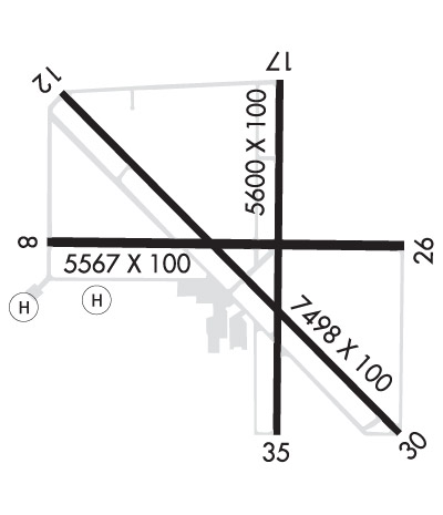
Runway Identification: 08/26Length: 5567 ft
Width: 100 ft
Surface: ASPHALT-FAIR CONDITION
Edge lights: Medium IntensityTreatment: NONE
Weight: PCN 25 /F/A/W/T
| | Runway: 08 | | Runway: 26 |
| Mag heading: | 75° | Mag heading: | 255° |
| Rwy Slope: | -.43% Down | Rwy Slope: | .43% Up |
| Approach: | | Approach: | |
| Pattern: | Left Traffic | Pattern: | Left Traffic |
| Markings: | NONPRECISION INSTRUMENT | Markings: | NONPRECISION INSTRUMENT |
| Marking Condition: | GOOD | Marking Condition: | GOOD |
| Arresting Dev: | | Arresting Dev: | |
| Lat & Long: | N3722.4 W11822.4 | Lat. & Long.: | N3722.4 W11821.3 |
| Elev: | 4124.1 ft. MSL | Elev: | 4100.3 ft. MSL |
| TCH: | 30 ft. AGL | TCH: | 25 ft. AGL |
| Visual Glide Path: | 3.50 degrees | Visual Glide Path: | 3.00 degrees |
| Displaced Threshold: | No | Displaced Threshold: | No |
| Touchdown Zone: | YES | Touchdown Zone: | YES |
| Touchdown Elev.: | 4124.3 feet | Touchdown Elev.: | 4114.5 feet |
| Visual Glide Slope: | 2-Light PAPI on LEFT side of Runway; PAPI UNUSBL BYD 5 NM. | Visual Glide Slope: | 2-Light PAPI on LEFT side of Runway; PAPI UNUSBL BYD 2 NM. |
| RVR Equipment: | | RVR Equipment: | |
| RVV Equipment: | NO | RVV Equipment: | NO |
| Approach Lights: | | Approach Lights: | |
| REIL: | NO | REIL: | NO |
| Centerline Lights: | NO | Centerline Lights: | NO |
| Touchdown lights: | NO | Touchdown lights: | NO |
| Runway Category: | Runway with a Visual Approach | Runway Category: | Runway with a Visual Approach |
| Declared Distances: | | Declared Distances: | |
| Obstructions: | TREES | Obstructions: | |
| Marked: | NOT Marked/Lighted | Marked: | |
| Clearance slope: | 24:1 | Clearance slope: | 50:1 |
| Obstruction height: | 47 feet AGL | Obstruction height: | |
| Dist. from runway: | 1350 feet | Dist. from runway: | |
| Centerline offset: | 130 left of centerline | Centerline offset: | |
| Comments: | | Comments: | 10' DEEP DITCH 100' FROM THR. |
Runway Identification: 12/30Length: 7498 ft
Width: 100 ft
Surface: ASPHALT
Edge lights: Medium IntensityTreatment: POROUS FRICTION COURSE
Weight: PCN 50 /F/B/W/T
| | Runway: 12 | | Runway: 30 |
| Mag heading: | 120° | Mag heading: | 300° |
| Rwy Slope: | -.30% Down | Rwy Slope: | .30% Up |
| Approach: | | Approach: | |
| Pattern: | Left Traffic | Pattern: | Left Traffic |
| Markings: | NONPRECISION INSTRUMENT | Markings: | NONPRECISION INSTRUMENT |
| Marking Condition: | GOOD | Marking Condition: | GOOD |
| Arresting Dev: | | Arresting Dev: | |
| Lat & Long: | N3722.8 W11822.4 | Lat. & Long.: | N3721.9 W11821.3 |
| Elev: | 4122.6 ft. MSL | Elev: | 4100.0 ft. MSL |
| TCH: | 48 ft. AGL | TCH: | 52 ft. AGL |
| Visual Glide Path: | 3.00 degrees | Visual Glide Path: | 3.52 degrees |
| Displaced Threshold: | No | Displaced Threshold: | No |
| Touchdown Zone: | YES | Touchdown Zone: | YES |
| Touchdown Elev.: | 4122.7 feet | Touchdown Elev.: | 4110.9 feet |
| Visual Glide Slope: | 4-Light PAPI on LEFT side of Runway | Visual Glide Slope: | 4-Light PAPI on LEFT side of Runway; PAPI UNUSBL BYD 4 NM. |
| RVR Equipment: | | RVR Equipment: | |
| RVV Equipment: | NO | RVV Equipment: | NO |
| Approach Lights: | | Approach Lights: | |
| REIL: | YES | REIL: | YES |
| Centerline Lights: | NO | Centerline Lights: | NO |
| Touchdown lights: | NO | Touchdown lights: | NO |
| Runway Category: | Runway with a Non-precision Approach having visibility minimums greater than 3/4 mile | Runway Category: | Runway with a Non-precision Approach having visibility minimums greater than 3/4 mile |
| Declared Distances: | TORA:7498' TODA:7498' ASDA:7098' LDA:7098' | Declared Distances: | TORA:7498' TODA:7498' ASDA:6743' LDA:6743' |
| Obstructions: | | Obstructions: | PLINE |
| Marked: | | Marked: | NOT Marked/Lighted |
| Clearance slope: | 50:1 | Clearance slope: | 38:1 |
| Obstruction height: | | Obstruction height: | 35 feet AGL |
| Dist. from runway: | | Dist. from runway: | 1555 feet |
| Centerline offset: | | Centerline offset: | 175 feet left of centerline |
| Comments: | | Comments: | |
Runway Identification: 17/35Length: 5600 ft
Width: 100 ft
Surface: ASPHALT-GOOD CONDITION
Edge lights: Medium IntensityTreatment: POROUS FRICTION COURSE
Weight: PCN 49 /F/B/W/T
| | Runway: 17 | | Runway: 35 |
| Mag heading: | 165° | Mag heading: | 345° |
| Rwy Slope: | -.14% Down | Rwy Slope: | .14% Up |
| Approach: | LDA/DME | Approach: | |
| Pattern: | Left Traffic | Pattern: | Left Traffic |
| Markings: | NONPRECISION INSTRUMENT | Markings: | NONPRECISION INSTRUMENT |
| Marking Condition: | GOOD | Marking Condition: | GOOD |
| Arresting Dev: | | Arresting Dev: | |
| Lat & Long: | N3722.8 W11821.7 | Lat. & Long.: | N3721.9 W11821.7 |
| Elev: | 4112.5 ft. MSL | Elev: | 4104.9 ft. MSL |
| TCH: | 50 ft. AGL | TCH: | 50 ft. AGL |
| Visual Glide Path: | 3.50 degrees | Visual Glide Path: | 3.00 degrees |
| Displaced Threshold: | No | Displaced Threshold: | No |
| Touchdown Zone: | YES | Touchdown Zone: | YES |
| Touchdown Elev.: | 4112.7 feet | Touchdown Elev.: | 4109.9 feet |
| Visual Glide Slope: | 4-Light PAPI on LEFT side of Runway; PAPI UNUSBL BYD 5 NM. | Visual Glide Slope: | 4-Light PAPI on LEFT side of Runway; PAPI UNUSBL BYD 5 NM. |
| RVR Equipment: | | RVR Equipment: | |
| RVV Equipment: | NO | RVV Equipment: | NO |
| Approach Lights: | | Approach Lights: | |
| REIL: | YES | REIL: | YES |
| Centerline Lights: | NO | Centerline Lights: | NO |
| Touchdown lights: | NO | Touchdown lights: | NO |
| Runway Category: | Runway with a Non-precision Approach having visibility minimums greater than 3/4 mile | Runway Category: | Runway with a Visual Approach |
| Declared Distances: | | Declared Distances: | |
| Obstructions: | | Obstructions: | TREES |
| Marked: | | Marked: | NOT Marked/Lighted |
| Clearance slope: | 50:1 | Clearance slope: | 41:1 |
| Obstruction height: | | Obstruction height: | 30 feet AGL |
| Dist. from runway: | | Dist. from runway: | 1442 feet |
| Centerline offset: | | Centerline offset: | B |
| Comments: | | Comments: | |
Runway Identification: H1 HELIPADLength: 40 ft
Width: 40 ft
Surface: ASPHALT-FAIR CONDITION
Edge lights:
Treatment: NONE
Runway Identification: H2 HELIPADLength: 100 ft
Width: 100 ft
Surface: ASPHALT-FAIR CONDITION
Edge lights:
Treatment: NONE