Click here for more info on on SMS!

KBIE

BEATRICE MUNI
BEATRICE
NE
Time Zone: Central
Lat: N 4018.1
Long: W 09645.2
Elev: 1324
Var: -04
Longest Runway: 5602
AWOS: 125.32
CTAF: 122.8

FBO & Flight Services info for KBIE

FBOs: Update your Fuel Prices
Providing high quality fuel and services to you and your customers. Courtesy cars are available, call to reserve. Restaurants and motels nearby. Hangars available by reservation. Aircraft rental and flight instruction.
Ph: 402-223-5349 Fax: 402-228-4585 Freq: 122.8WebsiteE-Mail
Service
Jet
100LL
SAF
MoGas
Fuel Avail: PRIST PREMIXED
Full5.305.70    Last Update: 04/23/2024 09:39

Self  5.55    
Misc. Info: Address: 3301 N 6TH ST,   BEATRICE, NE 68310

AWOSPh: 402-228-3229
-
Freq: 125.32  
If you are an FBO, call 1-203-262-1700 to update your info or email: FltPlan.Advertising@garmin.com
Advertise your FBO on FltPlan.com

Runway & Approach Info for KBIE
Rwy
Length
Land Dist**
Approach*
  Rwy
Length
Land Dist**
Approach*
14
4401x75  4401'          
 
  
32
  4401x75  4401'          
 
18
5602x100  5602'          
 
  
36
  5602x100  5602'          
 
 * only ILS, LOC, LDA, and SDF approaches to a specific runway are shown
** For any Declared Landing Distance Available, please see A/FD or Approach plates
Runway Weight Capability (lbs.) Help
Runway IDSingle WheelDouble WheelDouble Tandem WheelDual Double Wheel
14/3235,00045,500N/AN/A
18/3635,00045,500N/AN/A
These numbers are Advisory and are not limits.   The Airport Manager should have more accurate Weight Limits
Approach Charts
Approaches    
Current Weather/Notams
Customs Information Send updates to Support@FltPlan.com
Customs Not Available
Database effective 05/16/2024
Airport Diagram of KBIE
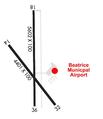
Airport Diagram might not be current.

Facility Name: BEATRICE MUNI
City Name: BEATRICE
County: GAGE
State abbrev: NE
State Name: NEBRASKA
   
Ownership: PUBLICLY OWNED
Use: OPEN TO THE PUBLIC
Owner's Name: CITY OF BEATRICE
Address: BOX 277
 BEATRICE, NE 68310-0277
Owner's Phone: 402-223-5349
  
Manager's Name: DENNIS SCHMITT
Address: P.O. BOX 277
 BEATRICE, NE 68310-0277
Phone: 402-223-5349
   
FAA Region: CENTRAL
FAA Field Office: NONE


Sunrise / Sunset times for BEATRICE MUNI

DateSunriseSunset
04/23/24 Tuesday6:3620:15
04/24/24 Wednesday6:3520:16
04/25/24 Thursday6:3320:17
04/26/24 Friday6:3220:18
04/27/24 Saturday6:3120:19
04/28/24 Sunday6:2920:20
04/29/24 Monday6:2820:21
04/30/24 Tuesday6:2720:22
05/01/24 Wednesday6:2520:23
05/02/24 Thursday6:2420:24
05/03/24 Friday6:2320:25
05/04/24 Saturday6:2220:26
05/05/24 Sunday6:2120:27
05/06/24 Monday6:1920:28

Airport Facilities

Airport Attendance Schedule7 Days A Week 0700-1900; WINTER HOURS 0700-1800
Airport Status OPERATIONAL (This Status can change at any time - please check NOTAMS)
Airport Lighting ScheduleACTVT MALSR RWY 36; REIL RWY 14 & 32 - CTAF. MIRL RWY 14/32 & RWY 18/36 OPR SS-SR. PAPI RWY 36 OPR CONSLY.
Airport Storage AvailableTie Downs, Hanger
Extra Services AvailableAir Freight, Crop Dusting, Avionics, Flight Instruction, Aircraft Rental
Wind IndicatorYES - (lighted)
Control TowerNO
CTAF Frequency122.800
Unicom Frequency122.800
Rotating Beacon ColorWG
Segmented CircleYES
Landing FeeNO

Airport Inspection Data

Airport InspectedSTATE - performed by STATE AERONAUTICAL PERSONNEL
Inspection Date06/21/2023

Airport Services

Type of Fuel AvailableGrade 100LL, JET A (freeze point -40C); -10FUEL AVBL H24 VIA CREDIT CARD.; -A JET A FUEL SVC AFT HRS CALL 913-433-4671 OR 402-520-0856.
Airframe Repair ServiceMINOR
Power Plant Repair ServiceMINOR

Geographic Data

LatitudeN4018.1
LongitudeW09645.2 (ESTIMATED)
Arpt Elevation1323ft (SURVEYED)
Magnetic Variation04E
3 miles Nof BEATRICE
Traffic Pattern Altitude
Sectional ChartOMAHA

Aircraft Data

Operations (Reported)YearlyAvg. Daily
General Aviation Transient 415011
General Aviation Local 595016
Air Taxi 7002
Commerical 00
Commuter 00
Military 2001
Aircraft based on Field
General Aviation Singles 32
General Aviation Multi 0
Jet Aircraft 0
General Aviation Helicopters 0
Military Aircraft 0
Gliders 0
Ultralights 0

FAA Services

FSS on field NO
FSS tie-in COLUMBUS
FSS Phone 1-800-WX-BRIEF
Who issues Notams BIE
Notam D service at airport YES
ARTCC Name MINNEAPOLIS

Federal Status

Airport Certification
Aircraft Rescue & Firefighting IndexNone
Airport of EntryNo
Custom Landing RightsNo
Joint Civil/MilitaryNo
Military Landing rightsYES

Federal Agreements

NATIONAL PLAN OF INTEGRATED AIRPORT SYSTEMS (NPIAS)
GRANT AGREEMENTS UNDER FAAP/ADAP/AIP
ASSURANCES PURSUANT TO TITLE VI, CIVIL RIGHTS ACT OF 1964
AGREEMENT UNDER DLAND OR DCLA HAS EXPIRED.

Remarks

RWY 18 IS DESIGNATED AS THE CALM WIND RWY.
400' STOPWAY AT RWY 36 DER.
FOR CD IF UNA TO CTC ON FSS FREQ, CTC MINNEAPOLIS ARTCC AT 651-463-5588.
Airport Communications & Frequencies:
CTAF Frequency:
122.800
Unicom Frequency:
122.800
Remarks
  • COMMUNICATIONS PRVDD BY COLUMBUS RADIO ON FREQ 122.5 (BEATRICE RCO).
  • APCH/DEP SVC PRVDD BY MINNEAPOLIS ARTCC ON FREQS 126.4/317.7 (MARYSVILLE RCAG).
  • Runway Identifications
    Runway Identification: 14/32
    Length: 4401 ft
    Width: 75 ft
    Surface: CONCRETE-GOOD CONDITION
    Edge lights: Medium Intensity

    Treatment: NONE

     Runway: 14   Runway: 32
    Mag heading: 139°Mag heading: 319°
    Rwy Slope: -.17% DownRwy Slope: .17% Up
    Approach: Approach:
    Pattern: Left TrafficPattern: Left Traffic
    Markings: NONPRECISION INSTRUMENTMarkings: NONPRECISION INSTRUMENT
    Marking Condition: GOODMarking Condition: GOOD
    Arresting Dev: Arresting Dev:
    Lat & Long: N4018.3  W09645.6Lat. & Long.: N4017.7  W09645.0
    Elev: 1319.2 ft. MSLElev: 1311.8 ft. MSL
    TCH: TCH:
    Visual Glide Path: Visual Glide Path:
    Displaced Threshold: NoDisplaced Threshold: No
    Touchdown Zone: YESTouchdown Zone: YES
    Touchdown Elev.: 1319.2 feetTouchdown Elev.: 1311.8 feet
    Visual Glide Slope: Visual Glide Slope:
    RVR Equipment: RVR Equipment:
    RVV Equipment: NORVV Equipment: NO
    Approach Lights: Approach Lights:
    REIL: YESREIL: YES
    Centerline Lights: NOCenterline Lights: NO
    Touchdown lights: NOTouchdown lights: NO
    Runway Category: Runway with a Non-precision Approach having visibility minimums greater than 3/4 mileRunway Category: Runway with a Non-precision Approach having visibility minimums greater than 3/4 mile
    Declared Distances: Declared Distances:
    Runway Identification: 18/36
    Length: 5602 ft
    Width: 100 ft
    Surface: CONCRETE-GOOD CONDITION
    Edge lights: Medium Intensity

    Treatment: NONE

     Runway: 18   Runway: 36
    Mag heading: 176°Mag heading: 356°
    Rwy Slope: -.34% DownRwy Slope: .34% Up
    Approach: Approach:
    Pattern: Left TrafficPattern: Left Traffic
    Markings: NONPRECISION INSTRUMENTMarkings: NONPRECISION INSTRUMENT
    Marking Condition: GOODMarking Condition: GOOD
    Arresting Dev: Arresting Dev:
    Lat & Long: N4018.6  W09645.2Lat. & Long.: N4017.7  W09645.2
    Elev: 1323.6 ft. MSLElev: 1304.6 ft. MSL
    TCH: TCH: 41 ft. AGL
    Visual Glide Path: Visual Glide Path: 3.00 degrees
    Displaced Threshold: NoDisplaced Threshold: No
    Touchdown Zone: YESTouchdown Zone: YES
    Touchdown Elev.: 1323.6 feetTouchdown Elev.: 1307.0 feet
    Visual Glide Slope: Visual Glide Slope: 2-Light PAPI on LEFT side of Runway
    RVR Equipment: RVR Equipment:
    RVV Equipment: NORVV Equipment: NO
    Approach Lights: Approach Lights: MALSR - 1,400 foot medium intensity approach lighting system with runway alignment indicator lights
    REIL: NOREIL: NO
    Centerline Lights: NOCenterline Lights: NO
    Touchdown lights: NOTouchdown lights: NO
    Runway Category: Runway with a Non-precision Approach having visibility minimums greater than 3/4 mileRunway Category: D
    Declared Distances: TORA:5602' TODA:5602' ASDA:5602' LDA:5602'Declared Distances: TORA:5602' TODA:5602' ASDA:6002' LDA:5602'
    C:5/P: