Click here for more info on on SMS!

KBHM

BIRMINGHAM-SHUTTLESWORTH INTL
BIRMINGHAM
AL
Time Zone: Central
Lat: N 3333.8
Long: W 08645.1
Elev: 650
Var: +03
Longest Runway: 12007
Clr Del: 125.67
Dept. ATIS: 119.4
Arr. ATIS: 119.4
Ground: 121.7
Tower: 119.9/118.25

FBO & Flight Services info for KBHM

FBOs: Update your Fuel Prices
Atlantic Aviation is your premier aviation service provider with more than 100 locations in North America, including Hawaii and the Caribbean. We provide standard ground services you'd expect, with a detailed focus on ensuring an unforgettable customer experience.
Ph: 205-849-5520 Fax: 205-849-3851 Freq: 131.97WebsiteE-Mail
                             
Service
Jet
100LL
SAF
MoGas
Fuel Avail: PRIST+ $0.08/gal.
Full7.377.70    Last Update: 04/18/2024 13:28:40

Self        
Misc. Info: All prices are 'Out The Door', call for volume discounts
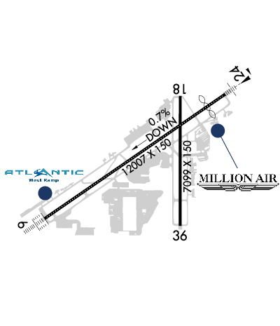
Address: 4243 EAST LAKE BLVD,   BIRMINGHAM, AL 35217

  click here  
Starting June 1, Million Air will take over the East side FBO at the airport. Our plans are to develop a fully modernized Million Air Birmingham. We are confident we can deliver a facility, level of service and amenities that will be unrivaled at this airport.
Ph: 659-223-3660
-
Freq: 130.3WebsiteE-Mail
                     
Service
Jet
100LL
SAF
MoGas
Fuel Avail: PRIST+$0.15/gal
Full7.297.44    Caution: Fuel prices have not been updated in 33 days.
Last Update: 03/17/2024 11:53

Self        
Misc. Info: Open 24/7Address: 4725 65TH PLACE N-INTL ARPT,   BIRMINGHAM, AL 35206

ASOSPh: 205-591-6172
-
-
 
If you are an FBO, call 1-203-262-1700 to update your info or email: FltPlan.Advertising@garmin.com
Advertise your FBO on FltPlan.com

Runway & Approach Info for KBHM
Rwy
Length
Land Dist**
Approach*
  Rwy
Length
Land Dist**
Approach*
06
12007x150  12007'          
ILS
 110.30 - 058°  
  
24
  12007x150  10802'          
ILS/DME
 109.50 - 238°  
18
7099x150  7099'          
LOC/DME
 111.30 - 183°  
  
36
  7099x150  7099'          
 
 * only ILS, LOC, LDA, and SDF approaches to a specific runway are shown
** For any Declared Landing Distance Available, please see A/FD or Approach plates
Runway Weight Capability (lbs.) Help
Runway IDSingle WheelDouble WheelDouble Tandem WheelDual Double Wheel
06/24175,000205,000350,000N/A
18/3675,000170,000240,000N/A
These numbers are Advisory and are not limits.   The Airport Manager should have more accurate Weight Limits
Approach Charts
Approaches    
Current Weather/Notams
Customs Information Send updates to Support@FltPlan.com
Phone 205-592-0237
Fax 205-592-0918

Comments 2 hours advance notice. Monday - Friday 0800 to 1700 Central time. * Call prior to 1430 on preceding weekday
Database effective 04/18/2024
Airport Diagram of KBHM
Airport Diagram might not be current.

Facility Name: BIRMINGHAM-SHUTTLESWORTH INTL
City Name: BIRMINGHAM
County: JEFFERSON
State abbrev: AL
State Name: ALABAMA
   
Ownership: PUBLICLY OWNED
Use: OPEN TO THE PUBLIC
Owner's Name: BIRMINGHAM AIRPORT AUTHORITY
Address: 5900 MESSER AIRPORT HWY
 BIRMINGHAM, AL 35212
Owner's Phone: (205) 599-0505
  
Manager's Name: RONALD MATHIEU
Address: BIRMINGHAM AIRPORT AUTHORITY, 5900 MESSER AIRPORT HWY
 BIRMINGHAM, AL 35212
Phone: (205) 599-0505
   
FAA Region: SOUTHERN
FAA Field Office: JAN
Overlying BHM north to south.Martin Von Almen 2022


Click here for full scale & interactive Sectional view of KBHM


Sunrise / Sunset times for BIRMINGHAM-SHUTTLESWORTH INTL

DateSunriseSunset
04/18/24 Thursday6:1219:21
04/19/24 Friday6:1119:22
04/20/24 Saturday6:1019:22
04/21/24 Sunday6:0919:23
04/22/24 Monday6:0719:24
04/23/24 Tuesday6:0619:25
04/24/24 Wednesday6:0519:25
04/25/24 Thursday6:0419:26
04/26/24 Friday6:0319:27
04/27/24 Saturday6:0219:28
04/28/24 Sunday6:0119:28
04/29/24 Monday6:0019:29
04/30/24 Tuesday5:5919:30
05/01/24 Wednesday5:5819:31

Airport Facilities

Airport Attendance ScheduleCONTINUOUS
Airport Status OPERATIONAL (This Status can change at any time - please check NOTAMS)
Airport Lighting Schedule
Airport Storage AvailableTie Downs, Hanger
Extra Services AvailableAir Freight, Air Ambulance, Avionics, Cargo Handling, Charter, Flight Instruction, Aircraft Rental, Aircraft Sales, Annual Surveying
Wind IndicatorYES - (lighted)
Control TowerYES
CTAF Frequency
Unicom Frequency122.950
Rotating Beacon ColorWG
Segmented CircleNO
Landing FeeNO

Airport Inspection Data

Airport InspectedFEDERAL - performed by FAA AIRPORTS FIELD PERSONNEL
Inspection Date03/11/2020

Airport Services

Type of Fuel AvailableGrade 100LL, JET A (freeze point -40C); -A A++100 (MIL)
Airframe Repair ServiceMAJOR
Power Plant Repair ServiceMAJOR

Geographic Data

LatitudeN3333.8
LongitudeW08645.1 (ESTIMATED)
Arpt Elevation650ft (SURVEYED)
Magnetic Variation03W
4 miles NEof BIRMINGHAM
Traffic Pattern Altitude
Sectional ChartATLANTA

Aircraft Data

Operations (Reported)YearlyAvg. Daily
General Aviation Transient 38613106
General Aviation Local 15674
Air Taxi 1640245
Commerical 3415894
Commuter 00
Military 794122
Aircraft based on Field
General Aviation Singles 73
General Aviation Multi 43
Jet Aircraft 102
General Aviation Helicopters 4
Military Aircraft 8
Gliders 0
Ultralights 0

FAA Services

FSS on field NO
FSS tie-in ANNISTON
FSS Phone 1-800-WX-BRIEF
Who issues Notams BHM
Notam D service at airport YES
ARTCC Name ATLANTA

Federal Status

Airport CertificationAIRPORT RECEIVING SCHEDULED AIR CARRIER SERVICE FROM CARRIERS CERTIFICATED BY THE CIVIL AERONAUTICS BOARD
Aircraft Rescue & Firefighting IndexAIRPORT HAS A CERTIFICATE UNDER CFR PART 139
Airport of EntryNo
Custom Landing RightsYES
Joint Civil/MilitaryNo
Military Landing rightsYES

Federal Agreements

NATIONAL PLAN OF INTEGRATED AIRPORT SYSTEMS (NPIAS)
GRANT AGREEMENTS UNDER FAAP/ADAP/AIP
SURPLUS PROPERTY AGREEMENT UNDER PUBLIC LAW 289
ASSURANCES PURSUANT TO TITLE VI, CIVIL RIGHTS ACT OF 1964

Remarks

TWY F BTN RWY 18/36 & TWY G RSTRD TO ACFT 100000 LBS OR LESS.
ANG: PPR RQR FOR ANG RAMP. NML OPR HRS 1300-2330Z++ TUE-FRI, CLSD WKNDS & HOL. NO SVC AVBL OUTSIDE THESE HRS WITHOUT PRIOR APVL. NO LCL OR ROUND-ROBIN FLT BY TRAN ACFT. CALL AIRFIELD OPS DSN 778-2555, C205-714-2555 FOR PPR 72 HR PRIOR (96 HRS FOR CARGO MSN). ALL INBD ACFT CTC ANG COMD POST "VULCN CONTROL" NO LATER THAN 15 MIN PRIOR TO LDG WITH PPR NR AND SUPPORT REQ. SPACE-A CAPABILITIES EXTREMELY LTD, PAX SVC LTD AVAILABILITY.
TWY H S OF TWY H4 RSTRD TO ACFT WITH WINGSPAN LESS THAN 117 FT.
TWY A BTN TWY A HLDG BAY AND TWY A3 RSTRD TO ACFT WITH WINGSPAN LESS THAN 150 FT.
TWY G RSTRD TO ACFT 65000 LBS OR LESS.
TWY M N OF RWY 6/24 RSTRD TO ACFT 75000 LBS OR LESS.
TWY N RSTRD TO ACFT 204000 LBS OR LESS.
BIRD ACTV INVOF RWYS.
Airport Communications & Frequencies:
ATIS Frequencies:   Hours(local) of Operation: CONTINUOUS
119.4
270.1
BIRMINGHAM Tower Frequencies:   Hours(local) of operation: CONTINUOUS   
118.25
119.9
317.725
BIRMINGHAM Ground Frequencies:
121.7
348.6
Clearance Delivery Frequencies:
125.675
305.2
Pre-Taxi Clearance Frequencies:
125.675
Emergency Frequencies:
121.5
243.0
Unicom Frequency:
122.950
BIRMINGHAM Primary Approach Frequencies:   Hours(local) of operation: CONTINUOUS   
123.8 ;050-230
127.675 ;231-049
256.8 ;050-230
338.2 ;231-049
BIRMINGHAM Primary Departure Frequencies:   Hours(local) of operation: CONTINUOUS   
123.8 ;050-230
127.675 ;231-049
256.8 ;050-230
338.2 ;231-049
Class C Frequencies:
123.8 ;050-230
127.675 ;231-049
256.8 ;050-230
338.2 ;231-049
Runway Identifications
Runway Identification: 06/24
Length: 12007 ft
Width: 150 ft
Surface: ASPHALT-GOOD CONDITION
Edge lights: High Intensity

Treatment: GROOVED
Weight: PCN 65 /F/C/X/T

 Runway: 06   Runway: 24
Mag heading: 58°Mag heading: 238°
Rwy Slope: .39% UpRwy Slope: -.39% Down
Approach: ILSApproach: ILS/DME
Pattern: Left TrafficPattern: Left Traffic
Markings: PRECISION INSTRUMENTMarkings: PRECISION INSTRUMENT
Marking Condition: FAIRMarking Condition: FAIR
Arresting Dev: Arresting Dev:
Lat & Long: N3333.3  W08646.3Lat. & Long.: N3334.4  W08644.3
Elev: 603.4 ft. MSLElev: 650.0 ft. MSL
TCH: 68 ft. AGLTCH: 69 ft. AGL
Visual Glide Path: 3.00 degreesVisual Glide Path: 3.00 degrees
Displaced Threshold: NoDisplaced Threshold: 1205 feet
Touchdown Zone: YESTouchdown Zone: YES
Touchdown Elev.: 606.0 feetTouchdown Elev.: 640.5 feet
Visual Glide Slope: 4-Light PAPI on LEFT side of RunwayVisual Glide Slope: 4-Light PAPI on LEFT side of Runway
RVR Equipment: TOUCHDOWN-MIDFIELD-ROLLOUTRVR Equipment: TOUCHDOWN-MIDFIELD-ROLLOUT
RVV Equipment: YESRVV Equipment: NO
Approach Lights: ALSF2 - standard 2,400 foot high intensity approach lighting system with sequenced flashers, Category II or IIIApproach Lights: MALSR - 1,400 foot medium intensity approach lighting system with runway alignment indicator lights; MALSR ATCT CTLD, OPS UMMONITORED.
REIL: NOREIL: NO
Centerline Lights: YESCenterline Lights: YES
Touchdown lights: YESTouchdown lights: NO
Runway Category: Precision Instrument RunwayRunway Category: Precision Instrument Runway
Declared Distances: TORA:12007' TODA:12007' ASDA:12007' LDA:12007'Declared Distances: TORA:12007' TODA:12007' ASDA:12007' LDA:10801'
Obstructions: TREESObstructions: GND
Marked: NOT Marked/LightedMarked: NOT Marked/Lighted
Clearance slope: 18:1Clearance slope: 16:1; APCH SLOPE 25:1 DUE TO 44 FT POLE, 4424 FT FROM DSPLCD THR.
Obstruction height: 58 feet AGLObstruction height: 67 feet AGL
Dist. from runway: 1290 feetDist. from runway: 1323 feet
Centerline offset: 654 right of centerlineCenterline offset: 610 feet right of centerline
Comments: Comments: NAVAID SHELTER 149 FT FM RWY END, 405 FT L, 1 FT ABV RWY END ELEV.
Runway Identification: 18/36
Length: 7099 ft
Width: 150 ft
Surface: ASPHALT-GOOD CONDITION
Edge lights: Medium Intensity

Treatment: GROOVED
Weight: PCN 45 /F/C/X/T

 Runway: 18   Runway: 36
Mag heading: 183°Mag heading:
Rwy Slope: -.15% DownRwy Slope: .15% Up
Approach: LOC/DMEApproach:
Pattern: Left TrafficPattern: Left Traffic
Markings: NONPRECISION INSTRUMENTMarkings: NONPRECISION INSTRUMENT
Marking Condition: GOODMarking Condition: GOOD
Arresting Dev: Arresting Dev:
Lat & Long: N3334.4  W08644.8Lat. & Long.: N3333.2  W08644.8
Elev: 644.3 ft. MSLElev: 633.5 ft. MSL
TCH: 51 ft. AGLTCH:
Visual Glide Path: 3.20 degreesVisual Glide Path:
Displaced Threshold: NoDisplaced Threshold: No
Touchdown Zone: YESTouchdown Zone: YES
Touchdown Elev.: 644.3 feetTouchdown Elev.: 633.5 feet
Visual Glide Slope: 4-Light PAPI on LEFT side of RunwayVisual Glide Slope:
RVR Equipment: RVR Equipment:
RVV Equipment: NORVV Equipment: NO
Approach Lights: Approach Lights:
REIL: YESREIL: YES
Centerline Lights: NOCenterline Lights: NO
Touchdown lights: NOTouchdown lights: NO
Runway Category: Runway with a Non-precision Approach having visibility minimums greater than 3/4 mileRunway Category: Runway with a Non-precision Approach having visibility minimums greater than 3/4 mile
Declared Distances: TORA:7099' TODA:7099' ASDA:7099' LDA:7099'Declared Distances: TORA:7099' TODA:7099' ASDA:7099' LDA:7099'
Obstructions: TREESObstructions: TREES
Marked: NOT Marked/LightedMarked: NOT Marked/Lighted
Clearance slope: 22:1Clearance slope: 18:1
Obstruction height: 245 feet AGLObstruction height: 62 feet AGL
Dist. from runway: 5689 feetDist. from runway: 1340 feet
Centerline offset: 883 right of centerlineCenterline offset: 210 feet left of centerline
Comments: Comments:
C:392/P: