
| ||||||||||||||||||||||||||||||||||||||||||||
| ||||||||||||||||||||||||||||||||||||||||||||
| ||||||||||||||||||||||||||||||||||||||||||||
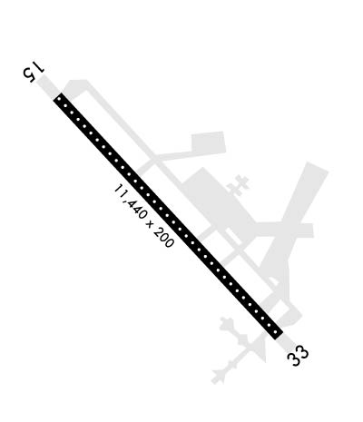
| Rwy | Rwy | |||||||
| 11440x200 | 11440' | 109.50 - 151° | 11440x200 | 11440' | 109.50 - 330° | |||
| Runway ID | Single Wheel | Double Wheel | Double Tandem Wheel | Dual Double Wheel |
| 15/33 | 100,000 | 210,000 | 400,000 | N/A |
| H1 | N/A | N/A | N/A | N/A |
| These numbers are Advisory and are not limits. The Airport Manager should have more accurate Weight Limits | ||||
 Airport Diagram might not be current. | |
| Facility Name: | BANGOR INTL |
| City Name: | BANGOR |
| County: | PENOBSCOT |
| State abbrev: | ME |
| State Name: | MAINE |
| Ownership: | PUBLICLY OWNED |
| Use: | OPEN TO THE PUBLIC |
| Owner's Name: | CITY OF BANGOR |
| Address: | 73 HARLOW STREET |
| BANGOR, ME 04401 | |
| Owner's Phone: | 207-992-4200 |
| Manager's Name: | TONY CARUSO |
| Address: | BANGOR INTERNATIONAL ARPT, 287 GODFREY BLVD. |
| BANGOR, ME 04401 | |
| Phone: | 207-992-4600 |
| FAA Region: | NEW ENGLAND |
| FAA Field Office: | NONE |

| Date | Sunrise | Sunset |
|---|---|---|
| 04/17/24 Wednesday | 5:46 | 19:24 |
| 04/18/24 Thursday | 5:45 | 19:25 |
| 04/19/24 Friday | 5:43 | 19:26 |
| 04/20/24 Saturday | 5:41 | 19:28 |
| 04/21/24 Sunday | 5:40 | 19:29 |
| 04/22/24 Monday | 5:38 | 19:30 |
| 04/23/24 Tuesday | 5:36 | 19:31 |
| 04/24/24 Wednesday | 5:35 | 19:33 |
| 04/25/24 Thursday | 5:33 | 19:34 |
| 04/26/24 Friday | 5:32 | 19:35 |
| 04/27/24 Saturday | 5:30 | 19:36 |
| 04/28/24 Sunday | 5:28 | 19:38 |
| 04/29/24 Monday | 5:27 | 19:39 |
| 04/30/24 Tuesday | 5:25 | 19:40 |
| Airport Attendance Schedule | CONTINUOUS |
| Airport Status | OPERATIONAL (This Status can change at any time - please check NOTAMS) |
| Airport Lighting Schedule | |
| Airport Storage Available | Tie Downs, Hanger |
| Extra Services Available | Air Freight, Cargo Handling, Charter, Flight Instruction, Aircraft Sales |
| Wind Indicator | YES - (lighted) |
| Control Tower | YES |
| CTAF Frequency | |
| Unicom Frequency | 122.950 |
| Rotating Beacon Color | WG |
| Segmented Circle | NO |
| Landing Fee | YES |
| Airport Inspected | FEDERAL - performed by FAA AIRPORTS FIELD PERSONNEL |
| Inspection Date | 07/09/2019 |
| Type of Fuel Available | Grade 100LL, JET A (freeze point -40C) |
| Airframe Repair Service | MAJOR |
| Power Plant Repair Service | MAJOR |
| Latitude | N4448.4 |
| Longitude | W06849.7 (ESTIMATED) |
| Arpt Elevation | 192ft (SURVEYED) |
| Magnetic Variation | 16W |
| 3 miles W | of BANGOR |
| Traffic Pattern Altitude | |
| Sectional Chart | HALIFAX |
| Operations (Reported) | Yearly | Avg. Daily |
|---|---|---|
| General Aviation Transient | 12963 | 36 |
| General Aviation Local | 4033 | 11 |
| Air Taxi | 11555 | 32 |
| Commerical | 5610 | 15 |
| Commuter | 0 | 0 |
| Military | 10521 | 29 |
| Aircraft based on Field | |
|---|---|
| General Aviation Singles | 33 |
| General Aviation Multi | 2 |
| Jet Aircraft | 1 |
| General Aviation Helicopters | 4 |
| Military Aircraft | 28 |
| Gliders | 0 |
| Ultralights | 0 |
| FSS on field | NO |
| FSS tie-in | BANGOR |
| FSS Phone | 1-800-WX-BRIEF |
| Who issues Notams | BGR |
| Notam D service at airport | YES |
| ARTCC Name | BOSTON |
| Airport Certification | AIRPORT RECEIVING SCHEDULED AIR CARRIER SERVICE FROM CARRIERS CERTIFICATED BY THE CIVIL AERONAUTICS BOARD; ARFF INDEX B WITH INDEX E CAPABILITIES AVBL 24/7. |
| Aircraft Rescue & Firefighting Index | AIRPORT HAS A CERTIFICATE UNDER CFR PART 139 |
| Airport of Entry | No |
| Custom Landing Rights | YES |
| Joint Civil/Military | No |
| Military Landing rights | YES |
| NATIONAL PLAN OF INTEGRATED AIRPORT SYSTEMS (NPIAS) |
| GRANT AGREEMENTS UNDER FAAP/ADAP/AIP |
| SURPLUS PROPERTY AGREEMENT UNDER PUBLIC LAW 289 |
| ASSURANCES PURSUANT TO TITLE VI, CIVIL RIGHTS ACT OF 1964 |
| THIS AIRPORT HAS BEEN SURVEYED BY THE NATIONAL GEODETIC SURVEY. |
| ANG: CAUTION: BASH PHASE II PERIOD SEP-NOV, APR-MAY. EXPECT INCREASED BIRD ACTIVITY. CONTACT BASE OPS/COMMAND POST/SOF FOR CURRENT BIRDWATCH COND. |
| FUEL: A++ (MIL). |
| SVC MIL-FLUID: OFF-BASE CONTRACTED LOX AVBL H24-RQR 24 HR NOTICE. |
| ANG: OPR 1100-1930Z++ MON-FRI, CLSD WKEND AND HOL. PPR RQRD FOR ANG RAMP. CTC AFLD MGMT DSN 698-7232, C207-404-7232 FOR PPR DURG OPR HRS. PRE-COORD ALL TRNSPN RQMNTS AND HAZ CARGO WITH PPR REQ. |
| ANG: PPR VALID +/- 1 HR UNLESS PRIOR CDN. 3 HR OUT CALL, 30 MIN OUT CALL 311.0 TO CFM CSTMS/AG AND TRAN SVC. COMMAND POST C207-404-7788 H24. |
| ANG: TRANSIENT ACFT MAY BE DIVERTED TO CIVILIAN SIDE DURING NON-DUTY HRS & WEEKENDS. FEE REQUIRED; NO ANG TRANSIENT ALERT. |
| TFC PAT: RWY 33 LEFT TFC, TURBO JET TFC 2000' MSL UNLESS OTHERWISE INSTR. |
| MISC: RWY 15-33 GROOVED. |
| ARNG: OPR 1230-2100Z++ MON-FRI EXC HOL. LTD MAINT. J8. PPR MAY-OCT SVC DSN 626-1100. |
Airport Communications & Frequencies:
| |||||||||||||||||||||||||||||||||||||||||||
| Runway: 15 | Runway: 33 | ||
| Mag heading: | 150° | Mag heading: | 330° |
| Rwy Slope: | -.26% Down | Rwy Slope: | .26% Up |
| Approach: | ILS/DME | Approach: | ILS/DME |
| Pattern: | Left Traffic | Pattern: | Left Traffic |
| Markings: | PRECISION INSTRUMENT | Markings: | PRECISION INSTRUMENT |
| Marking Condition: | GOOD | Marking Condition: | GOOD |
| Arresting Dev: | Arresting Dev: | ||
| Lat & Long: | N4449.1 W06850.6 | Lat. & Long.: | N4447.8 W06848.7 |
| Elev: | 192.1 ft. MSL | Elev: | 162.9 ft. MSL |
| TCH: | 55 ft. AGL | TCH: | 57 ft. AGL |
| Visual Glide Path: | 3.00 degrees | Visual Glide Path: | 3.00 degrees |
| Displaced Threshold: | No | Displaced Threshold: | No |
| Touchdown Zone: | YES | Touchdown Zone: | YES |
| Touchdown Elev.: | 192.1 feet | Touchdown Elev.: | 162.9 feet |
| Visual Glide Slope: | 4-Light PAPI on LEFT side of Runway | Visual Glide Slope: | 4-Light PAPI on LEFT side of Runway |
| RVR Equipment: | TOUCHDOWN-MIDFIELD-ROLLOUT | RVR Equipment: | TOUCHDOWN-MIDFIELD-ROLLOUT |
| RVV Equipment: | YES | RVV Equipment: | YES |
| Approach Lights: | ALSF2 - standard 2,400 foot high intensity approach lighting system with sequenced flashers, Category II or III | Approach Lights: | MALSR - 1,400 foot medium intensity approach lighting system with runway alignment indicator lights |
| REIL: | NO | REIL: | NO |
| Centerline Lights: | YES | Centerline Lights: | YES |
| Touchdown lights: | YES | Touchdown lights: | NO |
| Runway Category: | Precision Instrument Runway | Runway Category: | Precision Instrument Runway |
| Declared Distances: | TORA:11440' TODA:11440' ASDA:11440' LDA:11440' | Declared Distances: | TORA:11440' TODA:11440' ASDA:11440' LDA:11440' |
| Obstructions: | Obstructions: | TREES | |
| Marked: | Marked: | NOT Marked/Lighted | |
| Clearance slope: | 50:1 | Clearance slope: | 34:1 |
| Obstruction height: | Obstruction height: | 76 feet AGL | |
| Dist. from runway: | Dist. from runway: | 2800 feet | |
| Centerline offset: | Centerline offset: | ||
| Comments: | Comments: |