| ||||||||||||||||||||||||||||||||||||||||||||||||||||||||||||||||||||
| ||||||||||||||||||||||||||||||||||||||||||||||||||||||||||||||||||||
| ||||||||||||||||||||||||||||||||||||||||||||||||||||||||||||||||||||
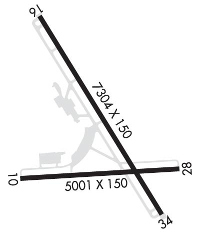
| Rwy | Rwy | |||||||
| 5001x150 | 5001' | 5001x150 | 5001' | |||||
| 7305x150 | 6905' | 110.30 - 157° | 7305x150 | 7100' | 110.30 - 340° | |||
| Runway ID | Single Wheel | Double Wheel | Double Tandem Wheel | Dual Double Wheel |
| 10/28 | 81,000 | 103,000 | 168,000 | N/A |
| 16/34 | 112,000 | 147,000 | 221,000 | N/A |
| H1 | N/A | N/A | N/A | N/A |
| These numbers are Advisory and are not limits. The Airport Manager should have more accurate Weight Limits | ||||
 Airport Diagram might not be current. | |
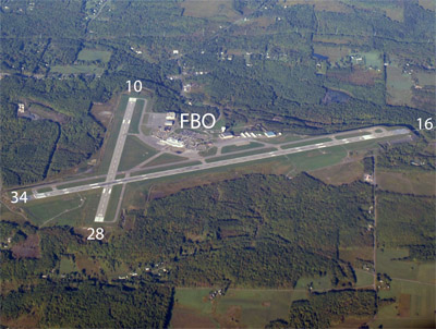
| Facility Name: | GREATER BINGHAMTON/EDWIN A LINK FLD |
| City Name: | BINGHAMTON |
| County: | BROOME |
| State abbrev: | NY |
| State Name: | NEW YORK |
| Ownership: | PUBLICLY OWNED |
| Use: | OPEN TO THE PUBLIC |
| Owner's Name: | BROOME COUNTY |
| Address: | 2534 AIRPORT ROAD #16 |
| JOHNSON CITY, NY 13790 | |
| Owner's Phone: | 607-763-4471 |
| Manager's Name: | MARK HEEFNER |
| Address: | 2534 AIRPORT ROAD, #16 |
| JOHNSON CITY, NY 13790 | |
| Phone: | 607-763-4471 |
| FAA Region: | EASTERN |
| FAA Field Office: | NYC |
| Date | Sunrise | Sunset |
|---|---|---|
| 04/18/24 Thursday | 6:17 | 19:50 |
| 04/19/24 Friday | 6:16 | 19:51 |
| 04/20/24 Saturday | 6:14 | 19:52 |
| 04/21/24 Sunday | 6:13 | 19:53 |
| 04/22/24 Monday | 6:11 | 19:54 |
| 04/23/24 Tuesday | 6:10 | 19:55 |
| 04/24/24 Wednesday | 6:08 | 19:56 |
| 04/25/24 Thursday | 6:07 | 19:57 |
| 04/26/24 Friday | 6:05 | 19:58 |
| 04/27/24 Saturday | 6:04 | 20:00 |
| 04/28/24 Sunday | 6:03 | 20:01 |
| 04/29/24 Monday | 6:01 | 20:02 |
| 04/30/24 Tuesday | 6:00 | 20:03 |
| 05/01/24 Wednesday | 5:58 | 20:04 |
| Airport Attendance Schedule | CONTINUOUS; FBO SVCS AVBL 0430-2200 SUN TO SAT. FOR AFT HRS FBO SVCS CTC 607-643-1640. |
| Airport Status | OPERATIONAL (This Status can change at any time - please check NOTAMS) |
| Airport Lighting Schedule | WHEN ATCT CLSD ACTVT MALSR RWY 16 & 34; HIRL RWY 16/34; MIRL RWY 10/28; TWY LGTS - CTAF.; DUSK-DAWN. |
| Airport Storage Available | Tie Downs, Hanger |
| Extra Services Available | Air Ambulance, Avionics, Cargo Handling, Charter, Flight Instruction, Aircraft Rental, Aircraft Sales |
| Wind Indicator | YES - (lighted) |
| Control Tower | YES |
| CTAF Frequency | 119.300 |
| Unicom Frequency | 122.950 |
| Rotating Beacon Color | WG |
| Segmented Circle | NO |
| Landing Fee | YES; LNDG FEE FOR MULTI-ENGINE & TURBINE ACFT OVER 4000 LBS. US CUSTOMS USER FEE ARPT. |
| Airport Inspected | FEDERAL - performed by FAA AIRPORTS FIELD PERSONNEL |
| Inspection Date | 06/13/2023 |
| Type of Fuel Available | Grade 100LL, JET A (freeze point -40C) |
| Airframe Repair Service | MINOR |
| Power Plant Repair Service | MINOR |
| Latitude | N4212.5 |
| Longitude | W07558.8 (ESTIMATED) |
| Arpt Elevation | 1635ft (SURVEYED) |
| Magnetic Variation | 12W |
| 7 miles N | of BINGHAMTON |
| Traffic Pattern Altitude | 800 |
| Sectional Chart | NEW YORK |
| Operations (Reported) | Yearly | Avg. Daily |
|---|---|---|
| General Aviation Transient | 7441 | 20 |
| General Aviation Local | 7266 | 20 |
| Air Taxi | 1443 | 4 |
| Commerical | 463 | 1 |
| Commuter | 0 | 0 |
| Military | 412 | 1 |
| Aircraft based on Field | |
|---|---|
| General Aviation Singles | 25 |
| General Aviation Multi | 10 |
| Jet Aircraft | 4 |
| General Aviation Helicopters | 0 |
| Military Aircraft | 0 |
| Gliders | 0 |
| Ultralights | 0 |
| FSS on field | NO |
| FSS tie-in | BUFFALO |
| FSS Phone | 1-800-WX-BRIEF |
| Who issues Notams | BGM |
| Notam D service at airport | YES |
| ARTCC Name | NEW YORK |
| Airport Certification | AIRPORT RECEIVING SCHEDULED AIR CARRIER SERVICE FROM CARRIERS CERTIFICATED BY THE CIVIL AERONAUTICS BOARD; PPR 12 HRS FOR UNSKED ACR OPNS WITH MORE THAN 9 PSGR SEATS 2300-0600 CALL AMGR 607-763-4474. ARFF AVBL 0530-0000 AND/OR UNTIL 15 MIN AFTER THE LAST SKED AIR CARRIER OPN. |
| Aircraft Rescue & Firefighting Index | AIRPORT HAS A CERTIFICATE UNDER CFR PART 139 |
| Airport of Entry | No |
| Custom Landing Rights | No; US CUSTOMS USER FEE ARPT. |
| Joint Civil/Military | No |
| Military Landing rights | YES |
| NATIONAL PLAN OF INTEGRATED AIRPORT SYSTEMS (NPIAS) |
| GRANT AGREEMENTS UNDER FAAP/ADAP/AIP |
| ASSURANCES PURSUANT TO TITLE VI, CIVIL RIGHTS ACT OF 1964 |
| ATCT UNABLE TO SEE HARD SFC SOUTH OF FBO HANGAR. |
| EXTENSIVE GLIDER ACTIVITY 10 NM SW OF ARPT. |
| BIRD ACTIVITY ON AND INVOF ARPT. |
| LGTD STRUCTURE 118 FT AGL 2000 FT SOUTH OF AER 10. |
| FOR CD IF UNA TO CTC ON FSS FREQ, CTC NEW YORK ARTCC AT 631-468-1425. |
| RWY 10/2 8 RWY 10 TKOFS AND LDGS NA WHEN ATCT CLSD. |
| RWY H1 HELIPAD LOCATED AT THE INTERSECTION OF TWY "L" & THE WEST APRON. |
Airport Communications & Frequencies:
| |||||||||||||||||||||||||||||||||||
| Runway: 10 | Runway: 28 | ||
| Mag heading: | 98° | Mag heading: | 278° |
| Rwy Slope: | -.38% Down | Rwy Slope: | .38% Up |
| Approach: | Approach: | ||
| Pattern: | Left Traffic | Pattern: | Left Traffic |
| Markings: | NONPRECISION INSTRUMENT | Markings: | NONPRECISION INSTRUMENT |
| Marking Condition: | GOOD | Marking Condition: | GOOD |
| Arresting Dev: | Arresting Dev: | ||
| Lat & Long: | N4212.3 W07559.3 | Lat. & Long.: | N4212.4 W07558.2 |
| Elev: | 1591.0 ft. MSL | Elev: | 1572.1 ft. MSL |
| TCH: | 53 ft. AGL | TCH: | 45 ft. AGL |
| Visual Glide Path: | 3.00 degrees | Visual Glide Path: | 3.00 degrees |
| Displaced Threshold: | No | Displaced Threshold: | No |
| Touchdown Zone: | YES | Touchdown Zone: | YES |
| Touchdown Elev.: | 1591.1 feet | Touchdown Elev.: | 1587.1 feet |
| Visual Glide Slope: | 4-BOX VASI ON LEFT SIDE OF RUNWAY | Visual Glide Slope: | 4-BOX VASI ON LEFT SIDE OF RUNWAY |
| RVR Equipment: | RVR Equipment: | ||
| RVV Equipment: | NO | RVV Equipment: | NO |
| Approach Lights: | Approach Lights: | ||
| REIL: | NO | REIL: | YES |
| Centerline Lights: | NO | Centerline Lights: | NO |
| Touchdown lights: | NO | Touchdown lights: | NO |
| Runway Category: | Runway with a Non-precision Approach having visibility minimums greater than 3/4 mile | Runway Category: | Runway with a Non-precision Approach having visibility minimums greater than 3/4 mile |
| Declared Distances: | TORA:5001' TODA:5001' ASDA:5001' LDA:5001' | Declared Distances: | TORA:5001' TODA:5001' ASDA:5001' LDA:5001' |
| Runway: 16 | Runway: 34 | ||
| Mag heading: | 160° | Mag heading: | 340° |
| Rwy Slope: | -.94% Down | Rwy Slope: | .94% Up |
| Approach: | ILS | Approach: | ILS |
| Pattern: | Left Traffic | Pattern: | Left Traffic |
| Markings: | PRECISION INSTRUMENT | Markings: | PRECISION INSTRUMENT |
| Marking Condition: | GOOD | Marking Condition: | GOOD |
| Arresting Dev: | EMAS; ENGINEERED MATERIALS ARRESTING SYSTEM (EMAS) 315 FT IN LENGTH BY 161 FT IN WIDTH LCTD AT THE DER 16. | Arresting Dev: | EMAS; ENGINEERED MATERIALS ARRESTING SYSTEM (EMAS) 311 FT IN LENGTH BY 161 FT WIDTH LCTD AT DER 34. |
| Lat & Long: | N4213.1 W07559.2 | Lat. & Long.: | N4212.1 W07558.3 |
| Elev: | 1635.6 ft. MSL | Elev: | 1566.8 ft. MSL |
| TCH: | 61 ft. AGL | TCH: | 64 ft. AGL |
| Visual Glide Path: | 3.00 degrees | Visual Glide Path: | 3.00 degrees |
| Displaced Threshold: | 400 feet | Displaced Threshold: | 205 feet |
| Touchdown Zone: | YES | Touchdown Zone: | YES |
| Touchdown Elev.: | 1633.8 feet | Touchdown Elev.: | 1600.9 feet |
| Visual Glide Slope: | 2-Light PAPI on LEFT side of Runway | Visual Glide Slope: | 2-Light PAPI on LEFT side of Runway |
| RVR Equipment: | TOUCHDOWN-ROLLOUT | RVR Equipment: | TOUCHDOWN-ROLLOUT |
| RVV Equipment: | YES | RVV Equipment: | YES |
| Approach Lights: | MALSR - 1,400 foot medium intensity approach lighting system with runway alignment indicator lights | Approach Lights: | MALSR - 1,400 foot medium intensity approach lighting system with runway alignment indicator lights |
| REIL: | NO | REIL: | NO |
| Centerline Lights: | NO | Centerline Lights: | NO |
| Touchdown lights: | NO | Touchdown lights: | NO |
| Runway Category: | Precision Instrument Runway | Runway Category: | Precision Instrument Runway |
| Declared Distances: | TORA:7305' TODA:7305' ASDA:7305' LDA:6905' | Declared Distances: | TORA:7305' TODA:7305' ASDA:7305' LDA:7100' |
| Obstructions: | ANT | Obstructions: | |
| Marked: | LIGHTED | Marked: | |
| Clearance slope: | 3:1 | Clearance slope: | 50:1 |
| Obstruction height: | 7 feet AGL | Obstruction height: | |
| Dist. from runway: | 225 feet | Dist. from runway: | |
| Centerline offset: | 250 left of centerline | Centerline offset: | |
| Comments: | Comments: |