
| ||||||||||||||||||||||||||||||||
| ||||||||||||||||||||||||||||||||
| ||||||||||||||||||||||||||||||||
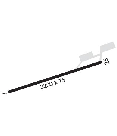
| Rwy | Rwy | |||||||
| 3200x75 | 3200' | 3200x75 | 3200' | |||||
| Runway ID | Single Wheel | Double Wheel | Double Tandem Wheel | Dual Double Wheel |
| 07/25 | 26,000 | N/A | N/A | N/A |
| These numbers are Advisory and are not limits. The Airport Manager should have more accurate Weight Limits | ||||
| FltPlan does not have IFR approach charts available for KBFW. |
 Airport Diagram might not be current. | |
| Facility Name: | SILVER BAY MUNI |
| City Name: | SILVER BAY |
| County: | LAKE |
| State abbrev: | MN |
| State Name: | MINNESOTA |
| Ownership: | PUBLICLY OWNED |
| Use: | OPEN TO THE PUBLIC |
| Owner's Name: | CITY OF SILVER BAY |
| Address: | 7 DAVIS DR |
| SILVER BAY, MN 55614-1397 | |
| Owner's Phone: | 218-226-4408 |
| Manager's Name: | LANA FRALICH/JAMES LARSON |
| Address: | CITY ADMINISTRATOR, 7 DAVIS DR |
| SILVER BAY, MN 55614-1397 | |
| Phone: | 218-226-4408; OR 218-220-1700. |
| FAA Region: | GREAT LAKES |
| FAA Field Office: | DMA |
| Date | Sunrise | Sunset |
|---|---|---|
| 04/23/24 Tuesday | 6:02 | 20:07 |
| 04/24/24 Wednesday | 6:00 | 20:08 |
| 04/25/24 Thursday | 5:58 | 20:10 |
| 04/26/24 Friday | 5:56 | 20:11 |
| 04/27/24 Saturday | 5:55 | 20:12 |
| 04/28/24 Sunday | 5:53 | 20:14 |
| 04/29/24 Monday | 5:51 | 20:15 |
| 04/30/24 Tuesday | 5:50 | 20:17 |
| 05/01/24 Wednesday | 5:48 | 20:18 |
| 05/02/24 Thursday | 5:47 | 20:19 |
| 05/03/24 Friday | 5:45 | 20:21 |
| 05/04/24 Saturday | 5:44 | 20:22 |
| 05/05/24 Sunday | 5:42 | 20:23 |
| 05/06/24 Monday | 5:41 | 20:25 |
| Airport Attendance Schedule | UNATTENDED |
| Airport Status | CLOSED PERMANENTLY (This Status can change at any time - please check NOTAMS) |
| Airport Lighting Schedule | ACTVT REIL RWY 07 & 25; PAPI RWY 07 & 25; MIRL RWY 07/25 - CTAF. |
| Airport Storage Available | Tie Downs, Hanger |
| Extra Services Available | NONE |
| Wind Indicator | YES - (lighted) |
| Control Tower | NO |
| CTAF Frequency | 122.900 |
| Unicom Frequency | |
| Rotating Beacon Color | WG |
| Segmented Circle | NO |
| Landing Fee | NO |
| Airport Inspected | STATE - performed by STATE AERONAUTICAL PERSONNEL |
| Inspection Date | 05/31/2018 |
| Type of Fuel Available | None |
| Airframe Repair Service | NONE |
| Power Plant Repair Service | NONE |
| Latitude | N4714.9 |
| Longitude | W09124.9 (ESTIMATED) |
| Arpt Elevation | 1088ft (SURVEYED) |
| Magnetic Variation | 00E |
| 7 miles SW | of SILVER BAY |
| Traffic Pattern Altitude | |
| Sectional Chart | GREEN BAY |
| Operations (Reported) | Yearly | Avg. Daily |
|---|---|---|
| General Aviation Transient | 900 | 2 |
| General Aviation Local | 2400 | 7 |
| Air Taxi | 0 | 0 |
| Commerical | 0 | 0 |
| Commuter | 0 | 0 |
| Military | 0 | 0 |
| Aircraft based on Field | |
|---|---|
| General Aviation Singles | 0 |
| General Aviation Multi | 0 |
| Jet Aircraft | 0 |
| General Aviation Helicopters | 0 |
| Military Aircraft | 0 |
| Gliders | 0 |
| Ultralights | 0 |
| FSS on field | NO |
| FSS tie-in | PRINCETON |
| FSS Phone | 1-800-WX-BRIEF |
| Who issues Notams | BFW |
| Notam D service at airport | YES |
| ARTCC Name | MINNEAPOLIS |
| Airport Certification | |
| Aircraft Rescue & Firefighting Index | None |
| Airport of Entry | No |
| Custom Landing Rights | No |
| Joint Civil/Military | No |
| Military Landing rights | YES |
| NATIONAL PLAN OF INTEGRATED AIRPORT SYSTEMS (NPIAS) |
| GRANT AGREEMENTS UNDER FAAP/ADAP/AIP |
| ASSURANCES PURSUANT TO TITLE VI, CIVIL RIGHTS ACT OF 1964 |
| ULTRALIGHT TRAFFIC ON & INVOF ARPT. |
| DEER AND WILDLIFE ON & INVOF ARPT. |
| NEW TRML BUILDING AVBL, FOR KEYPAD ENTRY PRESS 2, 4 TOGETHER AND THEN PRESS 3. |
| POT HOLES ON APN AND TIEDOWN AREA. |
| FOR CD CTC MINNEAPOLIS ARTCC AT 651-463-5588. |
| (ARPT STATUS) ARPT CLSD PERMLY. |
| RWY 07/2 5 RWY CLSD DUE TO EDGES CONTAIN LOOSE ROCKS AND CRUMBLING; LRG WDSPR CRACKS; VEGETATION GROWING THRU CRACKS AND JOINTS; MARKINGS FADED. |
Airport Communications & Frequencies:
| |||||||
| Runway: 07 | Runway: 25 | ||
| Mag heading: | 72° | Mag heading: | 252° |
| Rwy Slope: | -.18% Down | Rwy Slope: | .18% Up |
| Approach: | Approach: | ||
| Pattern: | Left Traffic | Pattern: | Left Traffic |
| Markings: | NONPRECISION INSTRUMENT | Markings: | NONPRECISION INSTRUMENT |
| Marking Condition: | FAIR | Marking Condition: | FAIR |
| Arresting Dev: | Arresting Dev: | ||
| Lat & Long: | N4714.9 W09125.3 | Lat. & Long.: | N4715.0 W09124.6 |
| Elev: | 1088.6 ft. MSL | Elev: | 1082.9 ft. MSL |
| TCH: | TCH: | ||
| Visual Glide Path: | Visual Glide Path: | 3.00 degrees | |
| Displaced Threshold: | No | Displaced Threshold: | No |
| Touchdown Zone: | YES | Touchdown Zone: | YES |
| Touchdown Elev.: | 1088.6 feet | Touchdown Elev.: | 1088.6 feet |
| Visual Glide Slope: | 4-Light PAPI on LEFT side of Runway | Visual Glide Slope: | 4-Light PAPI on LEFT side of Runway |
| RVR Equipment: | RVR Equipment: | ||
| RVV Equipment: | NO | RVV Equipment: | NO |
| Approach Lights: | Approach Lights: | ||
| REIL: | YES | REIL: | YES |
| Centerline Lights: | NO | Centerline Lights: | NO |
| Touchdown lights: | NO | Touchdown lights: | NO |
| Runway Category: | Runway with a Visual Approach | Runway Category: | Runway with a Non-precision Approach having visibility minimums greater than 3/4 mile |
| Declared Distances: | Declared Distances: | ||
| Obstructions: | TREES | Obstructions: | TREES |
| Marked: | NOT Marked/Lighted | Marked: | NOT Marked/Lighted |
| Clearance slope: | 17:1 | Clearance slope: | 21:1 |
| Obstruction height: | 44 feet AGL | Obstruction height: | 33 feet AGL |
| Dist. from runway: | 979 feet | Dist. from runway: | 918 feet |
| Centerline offset: | 185 right of centerline | Centerline offset: | 297 feet left of centerline |
| Comments: | Comments: |
