Current Weather/Notams (Metars, TAFs, Notams, NWS Forecast, PIREPS, and nearby weather)
Customs Information Send updates to Support@FltPlan.com
Customs Not Available
Database effective 05/16/2024
Airport Diagram might not be current.
|
| Facility Name: | TERRY COUNTY |
| City Name: | BROWNFIELD |
| County: | TERRY |
| State abbrev: | TX |
| State Name: | TEXAS |
| | |
| Ownership: | PUBLICLY OWNED |
| Use: | OPEN TO THE PUBLIC |
| Owner's Name: | TERRY COUNTY |
| Address: | TERRY CO COURTHOUSE |
| | BROWNFIELD, TX 79316 |
| Owner's Phone: | (806) 637-3797 |
| | |
| Manager's Name: | BRAD TANKERSLEY |
| Address: | P.O. BOX 205 |
| | BROWNFIELD, TX 79316 |
| Phone: | (806) 543-9840 |
| | |
| FAA Region: | SOUTHWEST |
| FAA Field Office: | TEX |
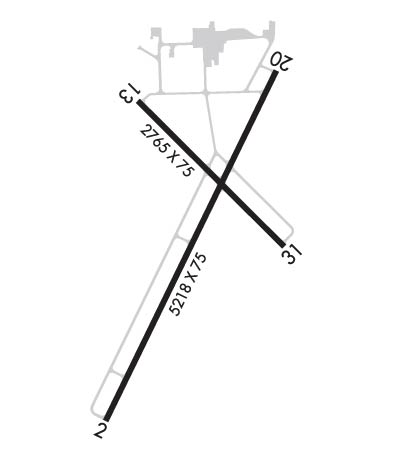
Runway Identifications
Runway Identification: 02/20Length: 5218 ft
Width: 75 ft
Surface: ASPHALT-GOOD CONDITION
Edge lights: Medium IntensityTreatment: NONE
| | Runway: 02 | | Runway: 20 |
| Mag heading: | 17° | Mag heading: | 197° |
| Rwy Slope: | .22% Up | Rwy Slope: | -.22% Down |
| Approach: | | Approach: | |
| Pattern: | Left Traffic | Pattern: | Left Traffic |
| Markings: | NONPRECISION INSTRUMENT | Markings: | NONPRECISION INSTRUMENT |
| Marking Condition: | GOOD | Marking Condition: | GOOD |
| Arresting Dev: | | Arresting Dev: | |
| Lat & Long: | N3309.9 W10211.8 | Lat. & Long.: | N3310.7 W10211.4 |
| Elev: | 3253.2 ft. MSL | Elev: | 3264.5 ft. MSL |
| TCH: | 43 ft. AGL | TCH: | 41 ft. AGL |
| Visual Glide Path: | 3.00 degrees | Visual Glide Path: | 3.00 degrees |
| Displaced Threshold: | No | Displaced Threshold: | No |
| Touchdown Zone: | YES | Touchdown Zone: | YES |
| Touchdown Elev.: | 3255.7 feet | Touchdown Elev.: | 3264.6 feet |
| Visual Glide Slope: | 2-Light PAPI on LEFT side of Runway | Visual Glide Slope: | 2-Light PAPI on LEFT side of Runway |
| RVR Equipment: | | RVR Equipment: | |
| RVV Equipment: | NO | RVV Equipment: | NO |
| Approach Lights: | | Approach Lights: | |
| REIL: | NO | REIL: | NO |
| Centerline Lights: | NO | Centerline Lights: | NO |
| Touchdown lights: | NO | Touchdown lights: | NO |
| Runway Category: | Runway with a Non-precision Approach having visibility minimums greater than 3/4 mile | Runway Category: | Runway with a Non-precision Approach having visibility minimums greater than 3/4 mile |
| Declared Distances: | | Declared Distances: | |
| Obstructions: | | Obstructions: | TREES |
| Marked: | | Marked: | NOT Marked/Lighted |
| Clearance slope: | 34:1 | Clearance slope: | 16:1 |
| Obstruction height: | | Obstruction height: | 40 feet AGL |
| Dist. from runway: | | Dist. from runway: | 840 feet |
| Centerline offset: | | Centerline offset: | 110 feet left of centerline |
| Comments: | | Comments: | |
Runway Identification: 13/31Length: 2765 ft
Width: 75 ft
Surface: ASPHALT-GOOD CONDITION
Edge lights: Treatment: NONE
| | Runway: 13 | | Runway: 31 |
| Mag heading: | 126° | Mag heading: | 306° |
| Rwy Slope: | -.41% Down | Rwy Slope: | .41% Up |
| Approach: | | Approach: | |
| Pattern: | Left Traffic | Pattern: | Left Traffic |
| Markings: | BASIC | Markings: | BASIC |
| Marking Condition: | GOOD | Marking Condition: | GOOD |
| Arresting Dev: | | Arresting Dev: | |
| Lat & Long: | N3310.7 W10211.7 | Lat. & Long.: | N3310.3 W10211.3 |
| Elev: | 3261.5 ft. MSL | Elev: | 3250.3 ft. MSL |
| TCH: | | TCH: | |
| Visual Glide Path: | | Visual Glide Path: | |
| Displaced Threshold: | No | Displaced Threshold: | No |
| Touchdown Zone: | YES | Touchdown Zone: | YES |
| Touchdown Elev.: | 3261.5 feet | Touchdown Elev.: | 3261.5 feet |
| Visual Glide Slope: | | Visual Glide Slope: | |
| RVR Equipment: | | RVR Equipment: | |
| RVV Equipment: | NO | RVV Equipment: | NO |
| Approach Lights: | | Approach Lights: | |
| REIL: | NO | REIL: | NO |
| Centerline Lights: | NO | Centerline Lights: | NO |
| Touchdown lights: | NO | Touchdown lights: | NO |
| Runway Category: | Runway with a Visual Approach | Runway Category: | Runway with a Visual Approach |
| Declared Distances: | | Declared Distances: | |
| Obstructions: | TREES | Obstructions: | ROAD |
| Marked: | NOT Marked/Lighted | Marked: | NOT Marked/Lighted |
| Clearance slope: | 29:1 | Clearance slope: | 45:1 |
| Obstruction height: | 60 feet AGL | Obstruction height: | 5 feet AGL |
| Dist. from runway: | 1960 feet | Dist. from runway: | 425 feet |
| Centerline offset: | | Centerline offset: | 147 feet right of centerline |
| Comments: | | Comments: | |

