Click here for more info on on SMS!

KBFA

BOYNE MOUNTAIN
BOYNE FALLS
MI
Time Zone: Eastern
Lat: N 4510.0
Long: W 08455.4
Elev: 719
Var: +06
Longest Runway: 5187
CTAF: 122.8

FBO & Flight Services info for KBFA

FBOs: Update your Fuel Prices

BOYNE MTN LODGEPh: 231-549-6000 Fax: 231-549-6094 Freq: 122.8
Service
Jet
100LL
SAF
MoGas
Full  6.00    Last Update: 04/04/2024 08:30

Self        
 Address: 1 BOYNE MOUNTAIN RD, PO BOX 19,   BOYNE FALLS, MI 49713
If you are an FBO, call 1-203-262-1700 to update your info or email: FltPlan.Advertising@garmin.com
Advertise your FBO on FltPlan.com

Runway & Approach Info for KBFA
Rwy
Length
Land Dist**
Approach*
  Rwy
Length
Land Dist**
Approach*
17
5187x100  4887'          
 
  
35
  5187x100  4687'          
 
 * only ILS, LOC, LDA, and SDF approaches to a specific runway are shown
** For any Declared Landing Distance Available, please see A/FD or Approach plates
Runway Weight Capability (lbs.) Help
Runway IDSingle WheelDouble WheelDouble Tandem WheelDual Double Wheel
17/35N/AN/AN/AN/A
These numbers are Advisory and are not limits.   The Airport Manager should have more accurate Weight Limits
Approach Charts
Approaches    
Current Weather/Notams
Customs Information Send updates to Support@FltPlan.com
Customs Not Available
Database effective 05/16/2024
Airport Diagram of KBFA
Airport Diagram might not be current.

Facility Name: BOYNE MOUNTAIN
City Name: BOYNE FALLS
County: CHARLEVOIX
State abbrev: MI
State Name: MICHIGAN
   
Ownership: PRIVATELY OWNED
Use: OPEN TO THE PUBLIC
Owner's Name: BOYNE USA INC
Address: 1 BOYNE MOUNTAIN RD
 BOYNE FALLS, MI 49713-9642
Owner's Phone: 231-549-6852
  
Manager's Name: CHRIS ADAMS
Address: BOYNE MOUNTAIN RESORT, PO BOX 19
 BOYNE FALLS, MI 49713-0019
Phone: 231-549-6852
   
FAA Region: GREAT LAKES
FAA Field Office: DET


Sunrise / Sunset times for BOYNE MOUNTAIN

DateSunriseSunset
04/24/24 Wednesday6:3820:38
04/25/24 Thursday6:3720:39
04/26/24 Friday6:3520:40
04/27/24 Saturday6:3420:42
04/28/24 Sunday6:3220:43
04/29/24 Monday6:3020:44
04/30/24 Tuesday6:2920:45
05/01/24 Wednesday6:2720:47
05/02/24 Thursday6:2620:48
05/03/24 Friday6:2520:49
05/04/24 Saturday6:2320:50
05/05/24 Sunday6:2220:52
05/06/24 Monday6:2020:53
05/07/24 Tuesday6:1920:54

Airport Facilities

Airport Attendance Schedule7 Days A Week 0800-1600
Airport Status OPERATIONAL (This Status can change at any time - please check NOTAMS)
Airport Lighting ScheduleACTVT REIL RWY 17 & 35; PAPI RWY 35; MIRL RWY 17/35 - 122.85.
Airport Storage AvailableNONE
Extra Services AvailableNONE
Wind IndicatorYES - (lighted)
Control TowerNO
CTAF Frequency122.800
Unicom Frequency122.800
Rotating Beacon Color
Segmented CircleYES
Landing FeeYES; FOR LDG FEES CTC AMGR FOR DTLS.

Airport Inspection Data

Airport InspectedSTATE - performed by STATE AERONAUTICAL PERSONNEL
Inspection Date07/01/2021

Airport Services

Type of Fuel AvailableGrade 100LL; -10NO SELF SVC AVBL.
Airframe Repair ServiceNone
Power Plant Repair ServiceNone

Geographic Data

LatitudeN4510.0
LongitudeW08455.4 (ESTIMATED)
Arpt Elevation719ft (SURVEYED)
Magnetic Variation06W
1 miles Wof BOYNE FALLS
Traffic Pattern Altitude
Sectional ChartLAKE HURON

Aircraft Data

Operations (Reported)YearlyAvg. Daily
General Aviation Transient 426512
General Aviation Local 4741
Air Taxi 00
Commerical 00
Commuter 00
Military 00
Aircraft based on Field
General Aviation Singles 0
General Aviation Multi 0
Jet Aircraft 0
General Aviation Helicopters 0
Military Aircraft 0
Gliders 0
Ultralights 0

FAA Services

FSS on field NO
FSS tie-in LANSING
FSS Phone 1-800-WX-BRIEF
Who issues Notams LAN
Notam D service at airport YES
ARTCC Name MINNEAPOLIS

Federal Status

Airport Certification
Aircraft Rescue & Firefighting IndexNone
Airport of EntryNo
Custom Landing RightsNo
Joint Civil/MilitaryNo
Military Landing rightsNo

Remarks

DEER & BIRDS ON & INVOF ARPT.
FOR CD CTC MINNEAPOLIS ARTCC AT 651-463-5588.
RWY 17/35 TREES, BLDGS, & ROADS IN PRI SFC.
PEDESTRIANS INVOF RWY ENVIRONMENT - LODGING 200 FT WEST OF RWY 35 DESIGNATOR.
Airport Communications & Frequencies:
CTAF Frequency:
122.800
Unicom Frequency:
122.800
Remarks
  • APCH/DEP SVC PRVDD BY MINNEAPOLIS ARTCC ON FREQS 134.6/354.05 (PELLSTON RCAG).
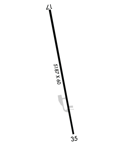
  • Runway Identifications
    Runway Identification: 17/35
    Length: 5187 ft
    Width: 100 ft
    Surface: ASPHALT
    Edge lights: Medium Intensity

    Treatment: GROOVED

     Runway: 17   Runway: 35
    Mag heading: 175°Mag heading: 355°
    Rwy Slope: .31% UpRwy Slope: -.31% Down
    Approach: Approach:
    Pattern: Left TrafficPattern: Left Traffic
    Markings: NONPRECISION INSTRUMENTMarkings: NONPRECISION INSTRUMENT
    Marking Condition: GOODMarking Condition: GOOD
    Arresting Dev: Arresting Dev:
    Lat & Long: N4510.4  W08455.6Lat. & Long.: N4509.5  W08455.3
    Elev: 703.0 ft. MSLElev: 719.0 ft. MSL
    TCH: TCH: 40 ft. AGL
    Visual Glide Path: Visual Glide Path: 3.00 degrees
    Displaced Threshold: 300 feetDisplaced Threshold: 500 feet
    Touchdown Zone: YESTouchdown Zone: YES
    Touchdown Elev.: 707.0 feetTouchdown Elev.: 719.0 feet
    Visual Glide Slope: Visual Glide Slope: 2-Light PAPI on LEFT side of Runway
    RVR Equipment: RVR Equipment:
    RVV Equipment: NORVV Equipment: NO
    Approach Lights: Approach Lights:
    REIL: YESREIL: YES
    Centerline Lights: NOCenterline Lights: NO
    Touchdown lights: NOTouchdown lights: NO
    Runway Category: Runway with a Non-precision ApproachRunway Category: Runway with a Non-precision Approach
    Declared Distances: Declared Distances:
    Obstructions: ROADObstructions: TREES
    Marked: NOT Marked/LightedMarked: NOT Marked/Lighted
    Clearance slope: APCH RATIO 20:1 TO DTHR OVR 15 FT ROAD, 300 FT DIST, 100 FT L.Clearance slope: APCH RATIO 14:1 TO DTHR OVR 38 FT TREES, 540 FT DIST, 170 FT R.
    Obstruction height: 15 feet AGLObstruction height: 20 feet AGL
    Dist. from runway: 200 feetDist. from runway: 200 feet
    Centerline offset: 55 right of centerlineCenterline offset: 90 feet right of centerline
    Comments: +15 FT ROAD, 0-199 FT DIST, 100 FT L TO 90 FT R.Comments: +25 FT TREES, 0-199 FT DIST, 40-250 FT R; +25 FT TREES, 0-80 FT DIST, 140 FT L.
    C:5/P: