Current Weather/Notams (Metars, TAFs, Notams, NWS Forecast, PIREPS, and nearby weather)
Customs Information Send updates to Support@FltPlan.com
Customs Not Available
Database effective 04/18/2024
Airport Diagram might not be current.
|
| Facility Name: | SOUTHWEST MICHIGAN RGNL |
| City Name: | BENTON HARBOR |
| County: | BERRIEN |
| State abbrev: | MI |
| State Name: | MICHIGAN |
| | |
| Ownership: | PUBLICLY OWNED |
| Use: | OPEN TO THE PUBLIC |
| Owner's Name: | BENTON HARBOR/ST JOSEPH |
| Address: | 1123 TERRITORIAL RD |
| | BENTON HARBOR, MI 49022-2939 |
| Owner's Phone: | 269-927-3194 |
| | |
| Manager's Name: | VINCENT DESJARDINS |
| Address: | 1123 TERRITORIAL RD |
| | BENTON HARBOR, MI 49022-2939 |
| Phone: | 269-927-3194; EXTN 10; CELL 269-921-9200. |
| | |
| FAA Region: | GREAT LAKES |
| FAA Field Office: | DET |
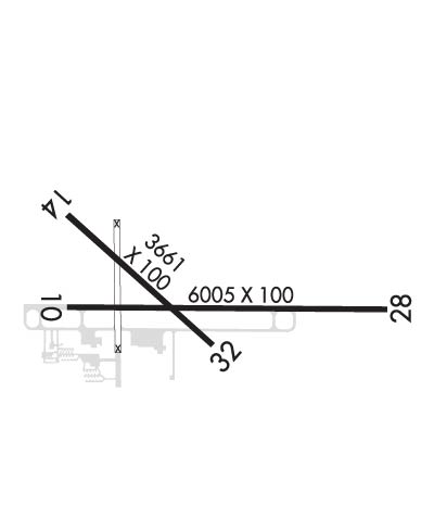
Runway Identifications
Runway Identification: 10/28Length: 6006 ft
Width: 100 ft
Surface: ASPHALT-GOOD CONDITION
Edge lights: High IntensityTreatment: GROOVED
| | Runway: 10 | | Runway: 28 |
| Mag heading: | 94° | Mag heading: | 274° |
| Rwy Slope: | .36% Up | Rwy Slope: | -.36% Down |
| Approach: | | Approach: | ILS/DME |
| Pattern: | Left Traffic | Pattern: | Left Traffic |
| Markings: | PRECISION INSTRUMENT | Markings: | PRECISION INSTRUMENT |
| Marking Condition: | GOOD | Marking Condition: | GOOD |
| Arresting Dev: | | Arresting Dev: | |
| Lat & Long: | N4207.7 W08626.0 | Lat. & Long.: | N4207.7 W08624.7 |
| Elev: | 627.5 ft. MSL | Elev: | 649.1 ft. MSL |
| TCH: | 34 ft. AGL | TCH: | 44 ft. AGL |
| Visual Glide Path: | 3.00 degrees | Visual Glide Path: | 3.00 degrees |
| Displaced Threshold: | No | Displaced Threshold: | No |
| Touchdown Zone: | YES | Touchdown Zone: | YES |
| Touchdown Elev.: | 631.3 feet | Touchdown Elev.: | 649.1 feet |
| Visual Glide Slope: | 4-Light PAPI on LEFT side of Runway | Visual Glide Slope: | 4-Light PAPI on LEFT side of Runway |
| RVR Equipment: | | RVR Equipment: | |
| RVV Equipment: | NO | RVV Equipment: | NO |
| Approach Lights: | | Approach Lights: | MALSR - 1,400 foot medium intensity approach lighting system with runway alignment indicator lights |
| REIL: | YES | REIL: | NO |
| Centerline Lights: | NO | Centerline Lights: | NO |
| Touchdown lights: | NO | Touchdown lights: | NO |
| Runway Category: | Runway with a Non-precision Approach having visibility minimums greater than 3/4 mile | Runway Category: | Precision Instrument Runway |
| Declared Distances: | | Declared Distances: | |
| Obstructions: | | Obstructions: | TREES |
| Marked: | | Marked: | NOT Marked/Lighted |
| Clearance slope: | 34:1 | Clearance slope: | 34:1 |
| Obstruction height: | | Obstruction height: | 105 feet AGL |
| Dist. from runway: | | Dist. from runway: | 3881 feet |
| Centerline offset: | | Centerline offset: | 976 feet right of centerline |
| Comments: | | Comments: | |
Runway Identification: 14/32Length: 3205 ft
Width: 60 ft
Surface: ASPHALT-FAIR CONDITION
Edge lights: Medium IntensityTreatment: NONE
| | Runway: 14 | | Runway: 32 |
| Mag heading: | 136° | Mag heading: | 316° |
| Rwy Slope: | .13% Up | Rwy Slope: | -.13% Down |
| Approach: | | Approach: | |
| Pattern: | Left Traffic | Pattern: | Left Traffic |
| Markings: | BASIC | Markings: | BASIC |
| Marking Condition: | GOOD | Marking Condition: | GOOD |
| Arresting Dev: | | Arresting Dev: | |
| Lat & Long: | N4207.9 W08626.0 | Lat. & Long.: | N4207.6 W08625.5 |
| Elev: | 627.0 ft. MSL | Elev: | 631.2 ft. MSL |
| TCH: | 36 ft. AGL | TCH: | 36 ft. AGL |
| Visual Glide Path: | 3.50 degrees | Visual Glide Path: | 3.50 degrees |
| Displaced Threshold: | No | Displaced Threshold: | No |
| Touchdown Zone: | YES | Touchdown Zone: | YES |
| Touchdown Elev.: | 630.5 feet | Touchdown Elev.: | 631.2 feet |
| Visual Glide Slope: | 2-Light PAPI on LEFT side of Runway | Visual Glide Slope: | 2-Light PAPI on LEFT side of Runway |
| RVR Equipment: | | RVR Equipment: | |
| RVV Equipment: | NO | RVV Equipment: | NO |
| Approach Lights: | | Approach Lights: | |
| REIL: | YES | REIL: | YES |
| Centerline Lights: | NO | Centerline Lights: | NO |
| Touchdown lights: | NO | Touchdown lights: | NO |
| Runway Category: | Runway with a Visual Approach | Runway Category: | Runway with a Visual Approach |
| Declared Distances: | | Declared Distances: | |
| Obstructions: | | Obstructions: | TREE |
| Marked: | | Marked: | NOT Marked/Lighted |
| Clearance slope: | 20:1 | Clearance slope: | 16:1 |
| Obstruction height: | | Obstruction height: | 83 feet AGL |
| Dist. from runway: | | Dist. from runway: | 1601 feet |
| Centerline offset: | | Centerline offset: | 244 feet right of centerline |
| Comments: | | Comments: | |

