Approach Charts
| FltPlan does not have IFR approach charts available for KBDU. |
Current Weather/Notams (Metars, TAFs, Notams, NWS Forecast, PIREPS, and nearby weather)
Customs Information Send updates to Support@FltPlan.com
Customs Not Available
Database effective 04/18/2024
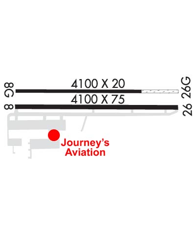
Airport Diagram might not be current.
|
| Facility Name: | BOULDER MUNI |
| City Name: | BOULDER |
| County: | BOULDER |
| State abbrev: | CO |
| State Name: | COLORADO |
| | |
| Ownership: | PUBLICLY OWNED |
| Use: | OPEN TO THE PUBLIC |
| Owner's Name: | CITY OF BOULDER |
| Address: | PO BOX 791 |
| | BOULDER, CO 80306 |
| Owner's Phone: | 303-441-3108 |
| | |
| Manager's Name: | JOHN KINNEY |
| Address: | 3327 AIRPORT ROAD |
| | BOULDER, CO 80301 |
| Phone: | 303-441-3108 |
| | |
| FAA Region: | NORTHWEST MOUNTAIN |
| FAA Field Office: | DEN |
Runway Identifications
Runway Identification: 08/26Length: 4100 ft
Width: 75 ft
Surface: ASPHALT-GOOD CONDITION
Edge lights: Medium IntensityTreatment: NONE
Weight: PCN 11 /F/C/X/U
| | Runway: 08 | | Runway: 26 |
| Mag heading: | 78° | Mag heading: | 258° |
| Rwy Slope: | -.22% Down | Rwy Slope: | .22% Up |
| Approach: | | Approach: | |
| Pattern: | Left Traffic | Pattern: | Right Traffic |
| Markings: | BASIC | Markings: | BASIC |
| Marking Condition: | GOOD | Marking Condition: | GOOD |
| Arresting Dev: | | Arresting Dev: | |
| Lat & Long: | N4002.3 W10514.0 | Lat. & Long.: | N4002.3 W10513.1 |
| Elev: | 5288.0 ft. MSL | Elev: | 5278.8 ft. MSL |
| TCH: | | TCH: | 40 ft. AGL |
| Visual Glide Path: | | Visual Glide Path: | 3.50 degrees |
| Displaced Threshold: | 200 feet | Displaced Threshold: | No |
| Touchdown Zone: | YES | Touchdown Zone: | YES |
| Touchdown Elev.: | 5288.0 feet | Touchdown Elev.: | 5278.8 feet |
| Visual Glide Slope: | | Visual Glide Slope: | 4-Light PAPI on LEFT side of Runway |
| RVR Equipment: | | RVR Equipment: | |
| RVV Equipment: | NO | RVV Equipment: | NO |
| Approach Lights: | | Approach Lights: | |
| REIL: | NO | REIL: | NO |
| Centerline Lights: | NO | Centerline Lights: | NO |
| Touchdown lights: | NO | Touchdown lights: | NO |
| Runway Category: | Runway with a Visual Approach | Runway Category: | Runway with a Visual Approach |
| Declared Distances: | TORA:4100' TODA:4100' ASDA:4100' LDA:3900' | Declared Distances: | TORA:4100' TODA:4100' ASDA:3900' LDA:3900' |
| Obstructions: | TREES | Obstructions: | |
| Marked: | NOT Marked/Lighted | Marked: | |
| Clearance slope: | 9:1 | Clearance slope: | 50:1 |
| Obstruction height: | 8 feet AGL | Obstruction height: | |
| Dist. from runway: | 275 feet | Dist. from runway: | |
| Centerline offset: | 49 right of centerline | Centerline offset: | |
| Comments: | | Comments: | |
Runway Identification: 08G/26GLength: 4100 ft
Width: 20 ft
Surface: ASPHALT GRASS-FAIR CONDITION
Edge lights: Treatment: NONE
| | Runway: 08G | | Runway: 26G |
| Mag heading: | N/A | Mag heading: | N/A |
| Rwy Slope: | -.32% Down | Rwy Slope: | .32% Up |
| Approach: | | Approach: | |
| Pattern: | Left Traffic | Pattern: | Right Traffic |
| Markings: | | Markings: | |
| Marking Condition: | | Marking Condition: | |
| Arresting Dev: | | Arresting Dev: | |
| Lat & Long: | N4002.4 W10514.0 | Lat. & Long.: | N4002.4 W10513.1 |
| Elev: | 5287.0 ft. MSL | Elev: | 5274.0 ft. MSL |
| TCH: | | TCH: | |
| Visual Glide Path: | | Visual Glide Path: | |
| Displaced Threshold: | No | Displaced Threshold: | No |
| Touchdown Zone: | NO | Touchdown Zone: | NO |
| Touchdown Elev.: | | Touchdown Elev.: | |
| Visual Glide Slope: | | Visual Glide Slope: | |
| RVR Equipment: | | RVR Equipment: | |
| RVV Equipment: | NO | RVV Equipment: | NO |
| Approach Lights: | | Approach Lights: | |
| REIL: | NO | REIL: | NO |
| Centerline Lights: | NO | Centerline Lights: | NO |
| Touchdown lights: | NO | Touchdown lights: | NO |
| Runway Category: | Runway with a Visual Approach | Runway Category: | Runway with a Visual Approach |
| Declared Distances: | | Declared Distances: | |
| Obstructions: | TREES | Obstructions: | |
| Marked: | NOT Marked/Lighted | Marked: | |
| Clearance slope: | 14:1 | Clearance slope: | 50:1 |
| Obstruction height: | 53 feet AGL | Obstruction height: | |
| Dist. from runway: | 790 feet | Dist. from runway: | |
| Centerline offset: | 115 left of centerline | Centerline offset: | |
| Comments: | | Comments: | |

