
| |||||||||||||||||||||||||||||||||||||||||||||||||||||||||||||||||||||
| |||||||||||||||||||||||||||||||||||||||||||||||||||||||||||||||||||||
| |||||||||||||||||||||||||||||||||||||||||||||||||||||||||||||||||||||
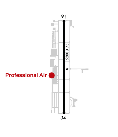
| Rwy | Rwy | |||||||
| 5201x75 | 5201' | 5201x75 | 5201' | |||||
| Runway ID | Single Wheel | Double Wheel | Double Tandem Wheel | Dual Double Wheel |
| 16/34 | 30,000 | N/A | N/A | N/A |
| These numbers are Advisory and are not limits. The Airport Manager should have more accurate Weight Limits | ||||
 Airport Diagram might not be current. | |
| Facility Name: | BEND MUNI |
| City Name: | BEND |
| County: | DESCHUTES |
| State abbrev: | OR |
| State Name: | OREGON |
| Ownership: | PUBLICLY OWNED |
| Use: | OPEN TO THE PUBLIC |
| Owner's Name: | CITY OF BEND |
| Address: | BOX 431 |
| BEND, OR 97701 | |
| Owner's Phone: | 541-389-0258 |
| Manager's Name: | TRACY WILLIAMS |
| Address: | BOX 431 |
| BEND, OR 97709 | |
| Phone: | 541-647-0828 |
| FAA Region: | NORTHWEST MOUNTAIN |
| FAA Field Office: | SEA |
| Date | Sunrise | Sunset |
|---|---|---|
| 04/23/24 Tuesday | 6:07 | 20:00 |
| 04/24/24 Wednesday | 6:05 | 20:01 |
| 04/25/24 Thursday | 6:04 | 20:02 |
| 04/26/24 Friday | 6:02 | 20:03 |
| 04/27/24 Saturday | 6:01 | 20:05 |
| 04/28/24 Sunday | 5:59 | 20:06 |
| 04/29/24 Monday | 5:58 | 20:07 |
| 04/30/24 Tuesday | 5:56 | 20:08 |
| 05/01/24 Wednesday | 5:55 | 20:09 |
| 05/02/24 Thursday | 5:54 | 20:11 |
| 05/03/24 Friday | 5:52 | 20:12 |
| 05/04/24 Saturday | 5:51 | 20:13 |
| 05/05/24 Sunday | 5:49 | 20:14 |
| 05/06/24 Monday | 5:48 | 20:15 |
| Airport Attendance Schedule | SAT-SUN 0800-1700, MON-FRI 0730-1800 |
| Airport Status | OPERATIONAL (This Status can change at any time - please check NOTAMS) |
| Airport Lighting Schedule | ACTVT REIL RWY 16/34; PAPI RWY 16/34; MIRL RWY 16/34 - CTAF. |
| Airport Storage Available | Tie Downs, Hanger |
| Extra Services Available | Avionics, Charter, Glider, Flight Instruction, Aircraft Rental, Aircraft Sales, Glider Towing |
| Wind Indicator | YES - (lighted) |
| Control Tower | NO |
| CTAF Frequency | 123.000 |
| Unicom Frequency | 123.000 |
| Rotating Beacon Color | WG |
| Segmented Circle | YES; SEGMENTED CRC LCTD AT NE END OF ARPT. |
| Landing Fee | NO |
| Airport Inspected | STATE - performed by STATE AERONAUTICAL PERSONNEL |
| Inspection Date | 01/11/2023 |
| Type of Fuel Available | Grade 100LL, JET A (freeze point -40C) |
| Airframe Repair Service | MAJOR |
| Power Plant Repair Service | MAJOR |
| Latitude | N4405.7 |
| Longitude | W12112.0 (ESTIMATED) |
| Arpt Elevation | 3459ft (SURVEYED) |
| Magnetic Variation | 14E |
| 5 miles NE | of BEND |
| Traffic Pattern Altitude | |
| Sectional Chart | KLAMATH FALLS |
| Operations (Reported) | Yearly | Avg. Daily |
|---|---|---|
| General Aviation Transient | 69737 | 191 |
| General Aviation Local | 70338 | 193 |
| Air Taxi | 1000 | 3 |
| Commerical | 0 | 0 |
| Commuter | 0 | 0 |
| Military | 100 | 0 |
| Aircraft based on Field | |
|---|---|
| General Aviation Singles | 172 |
| General Aviation Multi | 15 |
| Jet Aircraft | 8 |
| General Aviation Helicopters | 22 |
| Military Aircraft | 0 |
| Gliders | 9; GLIDER OPR ON & INVOF ARPT. |
| Ultralights | 0 |
| FSS on field | NO |
| FSS tie-in | MC MINNVILLE |
| FSS Phone | 1-800-WX-BRIEF |
| Who issues Notams | MMV |
| Notam D service at airport | YES |
| ARTCC Name | SEATTLE |
| Airport Certification | |
| Aircraft Rescue & Firefighting Index | None |
| Airport of Entry | No |
| Custom Landing Rights | No |
| Joint Civil/Military | No |
| Military Landing rights | YES |
| NATIONAL PLAN OF INTEGRATED AIRPORT SYSTEMS (NPIAS) |
| GRANT AGREEMENTS UNDER FAAP/ADAP/AIP |
| CONVEYANCE UNDER SCETION 16, FEDERAL AIRPORT ACT OF 1946 OR SECTION 23, AIRPORT AND AIRWAY DEVELOPMENT ACT OF 1970 |
| ASSURANCES PURSUANT TO TITLE VI, CIVIL RIGHTS ACT OF 1964 |
| BOTH TWYS PARALLEL TO RY 16/34 MKD BY REFLECTORS. |
| RP FIXED WING TO RMN WEST OF RWY USING RP RWY 16 AND LP RWY 34. ROTOR WING TO RMN EAST OF RWY AND USE RP 34 AND LP 16. FIXED WING ACFT-NO TURNS BFR END OF RWY. |
| FOR CD CTC SEATTLE ARTCC AT 253-351-3694. |
| CALM WIND RWY IS RWY 16 |
| NOISE ABATEMENT PROCEDURES IN EFFECT, CALL FBO AT (541) 388-0019 |
| BE AWARE, INTENSE HELICOPTER TRAINING CONTINUALLY IN PROGRESS. |
| EXTENSIVE GEESE ACTIVITY REPORTED ON AND NEAR ARPT YEAR AROUND. DEER AND OTHER WILDLIFE MAY BE PRESENT. |
| APRON AREAS MAY BE HEAVILY CONGESTED AT TIMES WITH SVC VEHICLES, PEDESTRIAN AND AUTOMOBILE TFC. |
| TAXILANES AND APRON ARE NSTD. ACFT MAY REQUIRE WING WALKERS, PARKING GUIDANCE AND/OR TUGGING AT PILOT DISCRETION TO INSURE ACFT CLEARANCE FROM OBSTACLES. |
| TO AVOID PROPERTY DAMAGE EXERCISE JUDGEMENT AND COURTESY DURING RUN-UP IN VICINITY OF HANGARS. |
Airport Communications & Frequencies:
| |||||||||
| Runway: 16 | Runway: 34 | ||
| Mag heading: | 166° | Mag heading: | 346° |
| Rwy Slope: | 1.08% Up | Rwy Slope: | -1.08% Down |
| Approach: | Approach: | ||
| Pattern: | Right Traffic | Pattern: | Left Traffic |
| Markings: | NONPRECISION INSTRUMENT | Markings: | NONPRECISION INSTRUMENT |
| Marking Condition: | GOOD | Marking Condition: | GOOD |
| Arresting Dev: | Arresting Dev: | ||
| Lat & Long: | N4406.1 W12112.0 | Lat. & Long.: | N4405.2 W12112.0 |
| Elev: | 3403.0 ft. MSL | Elev: | 3459.4 ft. MSL |
| TCH: | 38 ft. AGL | TCH: | 44 ft. AGL |
| Visual Glide Path: | 3.00 degrees | Visual Glide Path: | 3.00 degrees |
| Displaced Threshold: | No | Displaced Threshold: | No |
| Touchdown Zone: | YES | Touchdown Zone: | YES |
| Touchdown Elev.: | 3432.0 feet | Touchdown Elev.: | 3459.4 feet |
| Visual Glide Slope: | 4-Light PAPI on LEFT side of Runway | Visual Glide Slope: | 4-Light PAPI on LEFT side of Runway |
| RVR Equipment: | RVR Equipment: | ||
| RVV Equipment: | NO | RVV Equipment: | NO |
| Approach Lights: | Approach Lights: | ||
| REIL: | YES | REIL: | YES |
| Centerline Lights: | NO | Centerline Lights: | NO |
| Touchdown lights: | NO | Touchdown lights: | NO |
| Runway Category: | Runway with a Non-precision Approach having visibility minimums greater than 3/4 mile | Runway Category: | Runway with a Non-precision Approach having visibility minimums greater than 3/4 mile |
| Declared Distances: | Declared Distances: | ||
| Obstructions: | TREES | Obstructions: | TREE |
| Marked: | NOT Marked/Lighted | Marked: | NOT Marked/Lighted |
| Clearance slope: | 19:1 | Clearance slope: | 25:1 |
| Obstruction height: | 18 feet AGL | Obstruction height: | 52 feet AGL |
| Dist. from runway: | 542 feet | Dist. from runway: | 1496 feet |
| Centerline offset: | 100 right of centerline | Centerline offset: | 250 feet left of centerline |
| Comments: | Comments: |


