Click here for more info on on SMS!

KBDH

WILLMAR MUNI-JOHN L RICE FIELD
WILLMAR
MN
Time Zone: Central
Lat: N 4507.0
Long: W 09507.8
Elev: 1126
Var: -04
Longest Runway: 5500
AWOS: 113.7
CTAF: 122.8

FBO & Flight Services info for KBDH

FBOs: Update your Fuel Prices
Full service FBO with staff ready to meet your needs. An Authorized Mooney Service Center, our mechanics & pilots specialize in Mooney aircraft, but are equipped to assist owners of a wide range of general aviation aircraft. Services ranging from specialized fuel tank repair & annual inspections along with flight instruction, pilot service, & Mooney parts sales. Make Oasis Aero your one stop shop.
Ph: 320-214-9669
-
Freq: 122.8WebsiteE-Mail
                                   
Service
Jet
100LL
SAF
MoGas
Fuel Avail: PRIST PREMIXED.
Full6.68      Last Update: 04/22/2024 14:35

Self  5.45    
Misc. Info: Address: 6600 HWY 40 WEST,   WILLMAR, MN 56201

AWOSPh: 320-235-8287
-
Freq: 113.7  
If you are an FBO, call 1-203-262-1700 to update your info or email: FltPlan.Advertising@garmin.com
Advertise your FBO on FltPlan.com

Runway & Approach Info for KBDH
Rwy
Length
Land Dist**
Approach*
  Rwy
Length
Land Dist**
Approach*
03
2980x250  2980'          
 
  
21
  2980x250  2980'          
 
13
5500x100  5500'          
LOC/GS
 109.50 - 125°  
  
31
  5500x100  5500'          
 
 * only ILS, LOC, LDA, and SDF approaches to a specific runway are shown
** For any Declared Landing Distance Available, please see A/FD or Approach plates
Runway Weight Capability (lbs.) Help
Runway IDSingle WheelDouble WheelDouble Tandem WheelDual Double Wheel
03/21N/AN/AN/AN/A
13/31N/AN/AN/AN/A
These numbers are Advisory and are not limits.   The Airport Manager should have more accurate Weight Limits
Approach Charts
Approaches    
Current Weather/Notams
Customs Information Send updates to Support@FltPlan.com
Customs Not Available
Database effective 05/16/2024
Airport Diagram of KBDH
Airport Diagram might not be current.

Facility Name: WILLMAR MUNI/JOHN L RICE FLD
City Name: WILLMAR
County: KANDIYOHI
State abbrev: MN
State Name: MINNESOTA
   
Ownership: PUBLICLY OWNED
Use: OPEN TO THE PUBLIC
Owner's Name: CITY OF WILLMAR
Address: PO BOX 755
 WILLMAR, MN 56201-0755
Owner's Phone: 320-235-4913
  
Manager's Name: ERIC RUDNINGEN
Address: PO BOX 755, 6600 HIGHWAY 40 W
 WILLMAR, MN 56201-0755
Phone: 320-894-1872
   
FAA Region: GREAT LAKES
FAA Field Office: DMA


Sunrise / Sunset times for WILLMAR MUNI/JOHN L RICE FLD

DateSunriseSunset
04/24/24 Wednesday6:1920:19
04/25/24 Thursday6:1820:20
04/26/24 Friday6:1620:21
04/27/24 Saturday6:1420:22
04/28/24 Sunday6:1320:24
04/29/24 Monday6:1120:25
04/30/24 Tuesday6:1020:26
05/01/24 Wednesday6:0820:27
05/02/24 Thursday6:0720:29
05/03/24 Friday6:0520:30
05/04/24 Saturday6:0420:31
05/05/24 Sunday6:0320:32
05/06/24 Monday6:0120:34
05/07/24 Tuesday6:0020:35

Airport Facilities

Airport Attendance Schedule7 Days A Week 0800-1700
Airport Status OPERATIONAL (This Status can change at any time - please check NOTAMS)
Airport Lighting ScheduleACTVT OR INCR INTST MALSR RWY 13; REIL RWY 31; PAPI RWY 13 & 31; HIRL RWY 13/31 - CTAF. HIRL RWY 13/31 PRESET LOW INTST SS-SR.
Airport Storage AvailableTie Downs, Hanger
Extra Services AvailableFlight Instruction, Aircraft Sales
Wind IndicatorYES - (lighted)
Control TowerNO
CTAF Frequency122.800
Unicom Frequency122.800
Rotating Beacon ColorWG
Segmented CircleNO
Landing Fee

Airport Inspection Data

Airport InspectedSTATE - performed by STATE AERONAUTICAL PERSONNEL
Inspection Date10/07/2021

Airport Services

Type of Fuel AvailableGrade 100LL, JET A (freeze point -40C); -10AVBL H24 SELF SVC VIA CREDIT CARD.; -A FOR SVC AFT HRS CALL FBO AT 320-214-9669.
Airframe Repair ServiceMAJOR
Power Plant Repair ServiceMAJOR

Geographic Data

LatitudeN4507.0
LongitudeW09507.8 (ESTIMATED)
Arpt Elevation1126ft (SURVEYED)
Magnetic Variation04E
2 miles Wof WILLMAR
Traffic Pattern Altitude974
Sectional ChartTWIN CITIES

Aircraft Data

Operations (Reported)YearlyAvg. Daily
General Aviation Transient 500014
General Aviation Local 1200033
Air Taxi 8002
Commerical 00
Commuter 00
Military 500
Aircraft based on Field
General Aviation Singles 40
General Aviation Multi 8
Jet Aircraft 1
General Aviation Helicopters 1
Military Aircraft 0
Gliders 0
Ultralights 0

FAA Services

FSS on field NO
FSS tie-in PRINCETON
FSS Phone 1-800-WX-BRIEF
Who issues Notams BDH
Notam D service at airport YES
ARTCC Name MINNEAPOLIS

Federal Status

Airport Certification
Aircraft Rescue & Firefighting IndexNone
Airport of EntryNo
Custom Landing RightsNo
Joint Civil/MilitaryNo
Military Landing rightsNo

Federal Agreements

NATIONAL PLAN OF INTEGRATED AIRPORT SYSTEMS (NPIAS)
GRANT AGREEMENTS UNDER FAAP/ADAP/AIP

Remarks

ABNDD ARPT 1 NM EAST.
FOR CD IF UNA TO CTC ON FSS FREQ, CTC MINNEAPOLIS ARTCC AT 651-463-5588.
RWY 03/2 1 NOT PLOWED WINTER MONTHS.
RWY 13/3 1 200 FT UNUSBL PAVEMENT BYD RWY, BOTH ENDS.
Airport Communications & Frequencies:
CTAF Frequency:
122.800
Unicom Frequency:
122.800
Remarks
  • APCH/DEP SVC PRVDD BY ZMP ON FREQS 125.5/323.1 (DARWIN RCAG).
  • Runway Identifications
    Runway Identification: 03/21
    Length: 2980 ft
    Width: 250 ft
    Surface: GRASS-FAIR CONDITION
    Edge lights:

    Treatment: NONE

     Runway: 03   Runway: 21
    Mag heading: 31°Mag heading: 211°
    Rwy Slope: -.09% DownRwy Slope: .09% Up
    Approach: Approach:
    Pattern: Left TrafficPattern: Left Traffic
    Markings: Markings:
    Marking Condition: YELLOW CONES.Marking Condition: YELLOW CONES.
    Arresting Dev: Arresting Dev:
    Lat & Long: N4506.7  W09507.6Lat. & Long.: N4507.1  W09507.2
    Elev: 1125.6 ft. MSLElev: 1123.0 ft. MSL
    TCH: TCH:
    Visual Glide Path: Visual Glide Path:
    Displaced Threshold: NoDisplaced Threshold: No
    Touchdown Zone: YESTouchdown Zone: YES
    Touchdown Elev.: 1125.8 feetTouchdown Elev.: 1125.8 feet
    Visual Glide Slope: Visual Glide Slope:
    RVR Equipment: RVR Equipment:
    RVV Equipment: NORVV Equipment: NO
    Approach Lights: Approach Lights:
    REIL: NOREIL: NO
    Centerline Lights: NOCenterline Lights: NO
    Touchdown lights: NOTouchdown lights: NO
    Runway Category: Runway with a Visual ApproachRunway Category: Runway with a Visual Approach
    Declared Distances: Declared Distances:
    Obstructions: Obstructions: CROPS
    Marked: Marked: NOT Marked/Lighted
    Clearance slope: 20:1Clearance slope: 8:1
    Obstruction height: Obstruction height: 4 feet AGL
    Dist. from runway: Dist. from runway: 35 feet
    Centerline offset: Centerline offset: 127 feet left of centerline
    Comments: Comments:
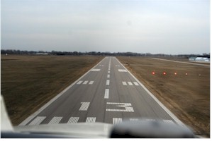
    Runway Identification: 13/31
    Length: 5500 ft
    Width: 100 ft
    Surface: ASPHALT-GOOD CONDITION
    Edge lights: High Intensity

    Treatment: NONE

     Runway: 13   Runway: 31
    Mag heading: 126°Mag heading: 306°
    Rwy Slope: .04% UpRwy Slope: -.04% Down
    Approach: LOC/GSApproach:
    Pattern: Left TrafficPattern: Left Traffic
    Markings: PRECISION INSTRUMENTMarkings: PRECISION INSTRUMENT
    Marking Condition: FAIRMarking Condition: FAIR
    Arresting Dev: Arresting Dev:
    Lat & Long: N4507.4  W09508.4Lat. & Long.: N4506.8  W09507.4
    Elev: 1123.6 ft. MSLElev: 1126.0 ft. MSL
    TCH: 50 ft. AGLTCH: 49 ft. AGL
    Visual Glide Path: 3.00 degreesVisual Glide Path: 3.00 degrees
    Displaced Threshold: NoDisplaced Threshold: No
    Touchdown Zone: YESTouchdown Zone: YES
    Touchdown Elev.: 1123.6 feetTouchdown Elev.: 1126.0 feet
    Visual Glide Slope: 4-Light PAPI on RIGHT side of RunwayVisual Glide Slope: 4-Light PAPI on LEFT side of Runway
    RVR Equipment: RVR Equipment:
    RVV Equipment: NORVV Equipment: NO
    Approach Lights: MALSR - 1,400 foot medium intensity approach lighting system with runway alignment indicator lightsApproach Lights:
    REIL: NOREIL: YES
    Centerline Lights: NOCenterline Lights: NO
    Touchdown lights: NOTouchdown lights: NO
    Runway Category: Precision Instrument RunwayRunway Category: D
    Declared Distances: Declared Distances:
    Obstructions: TREESObstructions:
    Marked: NOT Marked/LightedMarked:
    Clearance slope: 49:1Clearance slope: 34:1
    Obstruction height: 76 feet AGLObstruction height:
    Dist. from runway: 3934 feetDist. from runway:
    Centerline offset: 766 right of centerlineCenterline offset:
    Comments: Comments:
    C:14/P: