Current Weather/Notams (Metars, TAFs, Notams, NWS Forecast, PIREPS, and nearby weather)
Customs Information Send updates to Support@FltPlan.com
Phone 218-634-2803
Fax 218-634-9790
Comments 1 hr advance notice required. 24/7 Service.
Database effective 05/16/2024
Airport Diagram might not be current.
|
| Facility Name: | BAUDETTE INTL |
| City Name: | BAUDETTE |
| County: | LAKE OF THE WOODS |
| State abbrev: | MN |
| State Name: | MINNESOTA |
| | |
| Ownership: | PUBLICLY OWNED |
| Use: | OPEN TO THE PUBLIC |
| Owner's Name: | LAKE OF THE WOODS COUNTY; AND CITY OF BAUDETTE. |
| Address: | 206 8TH AVE SE |
| | BAUDETTE, MN 56623-2894 |
| Owner's Phone: | 218-634-1767 |
| | |
| Manager's Name: | PETE DUNN |
| Address: | 1103 AIRPORT RD NW, PO BOX 712 |
| | BAUDETTE, MN 56623-8937 |
| Phone: | 218-839-6488 |
| | |
| FAA Region: | GREAT LAKES |
| FAA Field Office: | DMA |
Runway Identifications
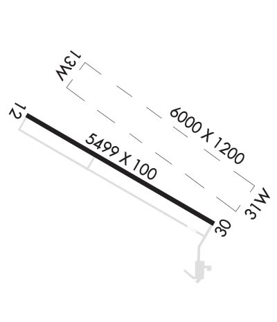
Runway Identification: 12/30Length: 5498 ft
Width: 100 ft
Surface: ASPHALT-GOOD CONDITION
Edge lights: High IntensityTreatment: NONE
| | Runway: 12 | | Runway: 30 |
| Mag heading: | 117° | Mag heading: | 297° |
| Rwy Slope: | -.03% Down | Rwy Slope: | .03% Up |
| Approach: | | Approach: | LOC/GS |
| Pattern: | Left Traffic | Pattern: | Left Traffic |
| Markings: | PRECISION INSTRUMENT | Markings: | PRECISION INSTRUMENT |
| Marking Condition: | GOOD | Marking Condition: | GOOD |
| Arresting Dev: | | Arresting Dev: | |
| Lat & Long: | N4843.9 W09437.3 | Lat. & Long.: | N4843.5 W09436.1 |
| Elev: | 1084.8 ft. MSL | Elev: | 1083.3 ft. MSL |
| TCH: | 47 ft. AGL | TCH: | 49 ft. AGL |
| Visual Glide Path: | 3.00 degrees | Visual Glide Path: | 3.00 degrees |
| Displaced Threshold: | No | Displaced Threshold: | No |
| Touchdown Zone: | YES | Touchdown Zone: | YES |
| Touchdown Elev.: | 1085.4 feet | Touchdown Elev.: | 1085.0 feet |
| Visual Glide Slope: | 4-Light PAPI on LEFT side of Runway | Visual Glide Slope: | 4-Light PAPI on LEFT side of Runway |
| RVR Equipment: | | RVR Equipment: | |
| RVV Equipment: | NO | RVV Equipment: | NO |
| Approach Lights: | | Approach Lights: | |
| REIL: | YES | REIL: | YES |
| Centerline Lights: | NO | Centerline Lights: | NO |
| Touchdown lights: | NO | Touchdown lights: | NO |
| Runway Category: | Runway with a Non-precision Approach having visibility minimums greater than 3/4 mile | Runway Category: | Precision Instrument Runway |
| Declared Distances: | | Declared Distances: | |
| Obstructions: | TREES | Obstructions: | BRDG |
| Marked: | NOT Marked/Lighted | Marked: | NOT Marked/Lighted |
| Clearance slope: | 31:1 | Clearance slope: | 44:1 |
| Obstruction height: | 55 feet AGL | Obstruction height: | 69 feet AGL |
| Dist. from runway: | 1955 feet | Dist. from runway: | 3290 feet |
| Centerline offset: | 362 right of centerline | Centerline offset: | |
| Comments: | | Comments: | |
Runway Identification: 13W/31WLength: 6000 ft
Width: 120 ft
Surface: WATER
Edge lights: Treatment: NONE
| | Runway: 13W | | Runway: 31W |
| Mag heading: | 123° | Mag heading: | 303° |
| Rwy Slope: | .00% | Rwy Slope: | .00% |
| Approach: | | Approach: | |
| Pattern: | Left Traffic | Pattern: | Left Traffic |
| Markings: | | Markings: | |
| Marking Condition: | | Marking Condition: | |
| Arresting Dev: | | Arresting Dev: | |
| Lat & Long: | N4844.2 W09437.2 | Lat. & Long.: | N4843.6 W09436.0 |
| Elev: | 1062.0 ft. MSL | Elev: | 1062.0 ft. MSL |
| TCH: | | TCH: | |
| Visual Glide Path: | | Visual Glide Path: | |
| Displaced Threshold: | No | Displaced Threshold: | No |
| Touchdown Zone: | YES | Touchdown Zone: | YES |
| Touchdown Elev.: | 1062.0 feet | Touchdown Elev.: | 1062.0 feet |
| Visual Glide Slope: | | Visual Glide Slope: | |
| RVR Equipment: | | RVR Equipment: | |
| RVV Equipment: | NO | RVV Equipment: | NO |
| Approach Lights: | | Approach Lights: | |
| REIL: | NO | REIL: | NO |
| Centerline Lights: | NO | Centerline Lights: | NO |
| Touchdown lights: | NO | Touchdown lights: | NO |
| Runway Category: | | Runway Category: | |
| Declared Distances: | | Declared Distances: | |

