Click here for more info on on SMS!

KBCT

Whisper PlateWhisper Track
BOCA RATON
BOCA RATON
FL
Time Zone: Eastern
Lat: N 2622.7
Long: W 08006.5
Elev: 13
Var: +05
Longest Runway: 6276
Clr Del: 121.8
AWOS: 121.12
Ground: 121.8
Tower: 118.42

FBO & Flight Services info for KBCT

FBOs: Update your Fuel Prices
Atlantic Aviation is your premier aviation service provider with more than 100 locations in North America, including Hawaii and the Caribbean. We provide standard ground services you'd expect, with a detailed focus on ensuring an unforgettable customer experience.
Ph: 561-368-1110 Fax: 561-392-7113 Freq: 131.95WebsiteE-Mail
                                   
Service
Jet
100LL
SAF
MoGas
Fuel Avail: 24/7
Full8.138.10    Last Update: 04/18/2024 13:28:40

Self        
Misc. Info: Call for volume discountsAddress: 3700 AIRPORT RD.   BOCA RATON, FL 33431

SIGNATUREPh: 561-955-9556 Fax: 561-347-2181 Freq: 130.90
Service
Jet
100LL
SAF
MoGas
Fuel Avail: 24/7. Jet A w/Prist, add $0.07 per gallon
Full8.278.45    Last Update: 04/19/2024 07:53  
Self        
 Address: 3300 AIRPORT ROAD   BOCA RATON, FLORIDA 33431
AIRPORT AUTHORITYPh: 561-391-2202
-
-
NOISE RESTRICTPh: 561-391-2202
-
-
 
AWOSPh: 561-391-2696
-
Freq: 121.12  
If you are an FBO, call 1-203-262-1700 to update your info or email: FltPlan.Advertising@garmin.com
Advertise your FBO on FltPlan.com

Runway & Approach Info for KBCT
Rwy
Length
Land Dist**
Approach*
  Rwy
Length
Land Dist**
Approach*
05
6276x150  5580'          
 
  
23
  6276x150  5898'          
 
 * only ILS, LOC, LDA, and SDF approaches to a specific runway are shown
** For any Declared Landing Distance Available, please see A/FD or Approach plates
Runway Weight Capability (lbs.) Help
Runway IDSingle WheelDouble WheelDouble Tandem WheelDual Double Wheel
05/2366,00095,000N/AN/A
These numbers are Advisory and are not limits.   The Airport Manager should have more accurate Weight Limits
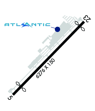
Approach Charts
Approaches    
Current Weather/Notams
Customs Information Send updates to Support@FltPlan.com
Phone 561-292-9231
Fax N/A

Comments US customs available Thursday through Monday from 10:30 a.m. to 6:30 p.m. although operators should verify before arrival. After-hours processing is available but with an additional callout fee.
Database effective 04/18/2024
Airport Diagram of KBCT
Airport Diagram might not be current.

Facility Name: BOCA RATON
City Name: BOCA RATON
County: PALM BEACH
State abbrev: FL
State Name: FLORIDA
   
Ownership: PUBLICLY OWNED
Use: OPEN TO THE PUBLIC
Owner's Name: BOCA RATON AIRPORT AUTHORITY
Address: 903 NW 35TH STREET
 BOCA RATON, FL 33431
Owner's Phone: 561-391-2202
  
Manager's Name: CLARA BENNETT
Address: 903 NW 35TH STREET
 BOCA RATON, FL 33431
Phone: 561-391-2202; EXT 211
   
FAA Region: SOUTHERN
FAA Field Office: ORL


Sunrise / Sunset times for BOCA RATON

DateSunriseSunset
04/18/24 Thursday6:5319:46
04/19/24 Friday6:5219:47
04/20/24 Saturday6:5219:47
04/21/24 Sunday6:5119:48
04/22/24 Monday6:5019:48
04/23/24 Tuesday6:4919:49
04/24/24 Wednesday6:4819:49
04/25/24 Thursday6:4719:50
04/26/24 Friday6:4619:50
04/27/24 Saturday6:4519:51
04/28/24 Sunday6:4519:51
04/29/24 Monday6:4419:52
04/30/24 Tuesday6:4319:52
05/01/24 Wednesday6:4219:53

Airport Facilities

Airport Attendance ScheduleCONTINUOUS
Airport Status OPERATIONAL (This Status can change at any time - please check NOTAMS)
Airport Lighting ScheduleWHEN ATCT CLSD ACTV REIL RWY 05 & 23, PAPI RWY 5 & 23; MIRL RWY 05/23 - CTAF.
Airport Storage AvailableTie Downs, Hanger
Extra Services AvailableAvionics, Charter, Flight Instruction, Aircraft Rental
Wind IndicatorYES - (lighted)
Control TowerYES
CTAF Frequency118.425
Unicom Frequency
Rotating Beacon ColorWG
Segmented CircleNO
Landing FeeNO

Airport Inspection Data

Airport InspectedSTATE - performed by STATE AERONAUTICAL PERSONNEL
Inspection Date04/30/2018

Airport Services

Type of Fuel AvailableGrade 100LL, JET A (freeze point -40C)
Airframe Repair ServiceMAJOR
Power Plant Repair ServiceMAJOR

Geographic Data

LatitudeN2622.7
LongitudeW08006.5 (ESTIMATED)
Arpt Elevation12ft (SURVEYED)
Magnetic Variation05W
2 miles NWof BOCA RATON
Traffic Pattern Altitude
Sectional ChartMIAMI

Aircraft Data

Operations (Reported)YearlyAvg. Daily
General Aviation Transient 3336791
General Aviation Local 42791117
Air Taxi 528914
Commerical 00
Commuter 00
Military 1030
Aircraft based on Field
General Aviation Singles 115
General Aviation Multi 23
Jet Aircraft 75
General Aviation Helicopters 5
Military Aircraft 0
Gliders 0
Ultralights 0

FAA Services

FSS on field NO
FSS tie-in MIAMI
FSS Phone 1-800-WX-BRIEF
Who issues Notams MIA
Notam D service at airport YES
ARTCC Name MIAMI

Federal Status

Airport Certification
Aircraft Rescue & Firefighting IndexNone
Airport of EntryNo
Custom Landing RightsNo; US CUSTOMS USER FEE ARPT.
Joint Civil/MilitaryNo
Military Landing rightsYES

Federal Agreements

NATIONAL PLAN OF INTEGRATED AIRPORT SYSTEMS (NPIAS)
GRANT AGREEMENTS UNDER FAAP/ADAP/AIP
SURPLUS PROPERTY AGREEMENT UNDER PUBLIC LAW 289
ASSURANCES PURSUANT TO TITLE VI, CIVIL RIGHTS ACT OF 1964

Remarks

NOISE ABATEMENT INFO - AMGR. VOLUNTARY NOISE ABATEMENT PROC IN EFCT ALL TIMES & ACFT. VOLUNTARY CURFEW 2200-0700. USE NBAA STD NOISE ABATEMENT APCH & DEP PROC.
FOR CD, IF UNA VIA GCO CTC PALM BEACH APCH AT 561-684-9047 OR 561-275-1430.
WHEN ATCT CLSD, GCO AVBL ON FREQ 127.35 PALM BEACH CD.
BIRDS ON AND INVOF ARPT.
USE RECOMMENDED DEP: RWY 05 L TURN HDG 360 STAY W OF INTERSTATE TO 1500 FT; RWY 23 R TURN HDG 255 AS SOON AS PRACTICABLE AFT PASSING RWY END TO 1500 FT; AVOID RESIDENTIAL AREAS; OVERFLY MALL AREA.
TGLS VOLUNTARILY RSTRD TO 0900-1700 MON-FRI; VOLUNTARY RESTRN ON STOP & GO LNDGS OR INT DEPS. VOLUNTARY RESTRN ON REPETITIVE PAT OPS.
MAINT RUNUP NA 0100-1300.
ACFT PRKG LTD DURG VIP TFR PDS.
US CUSTS USER FEE ARPT. US CUSTS AVBL THUR-MON 1030-1830 LCL - 561-292-9231. CLSD TO ARR OUTSIDE NML HR EXC O/R AND APVL BY US CUSTS; MNM ADDNL FEE. CTC US CUSTS 561-665-5842 FOR AFT HR APVL.
Airport Communications & Frequencies:
BOCA RATON Tower Frequencies:   Hours(local) of operation: 0700-2300   
118.425
BOCA RATON Ground Frequencies:
121.8
Clearance Delivery Frequencies:
121.8
CTAF Frequency:
118.425
PALM BEACH Primary Approach Frequencies:  
127.35
343.6
PALM BEACH Primary Departure Frequencies:  
127.35
343.6
Runway Identifications
Runway Identification: 05/23
Length: 6276 ft
Width: 150 ft
Surface: ASPHALT-GOOD CONDITION
Edge lights: Medium Intensity

Treatment: GROOVED
Weight: PCN 32 /F/A/X/T

 Runway: 05   Runway: 23
Mag heading: 49°Mag heading: 229°
Rwy Slope: .02% UpRwy Slope: -.02% Down
Approach: Approach:
Pattern: Left TrafficPattern: Right Traffic
Markings: NONPRECISION INSTRUMENTMarkings: NONPRECISION INSTRUMENT
Marking Condition: FAIRMarking Condition: FAIR
Arresting Dev: EMAS; ENGINEERED MATERIALS ARRESTING SYS (EMAS) 252 FT IN LEN BY 170 FT IN WID LCTD AT THE DER 05.Arresting Dev: EMAS; ENGINEERED MATERIALS ARRESTING SYS (EMAS) 300 FT IN LEN BY 170 FT IN WID LCTD AT THE DER 23.
Lat & Long: N2622.3  W08006.9Lat. & Long.: N2623.1  W08006.1
Elev: 11.4 ft. MSLElev: 12.7 ft. MSL
TCH: 46 ft. AGLTCH: 46 ft. AGL
Visual Glide Path: 3.25 degreesVisual Glide Path: 3.25 degrees
Displaced Threshold: 696 feetDisplaced Threshold: 378 feet
Touchdown Zone: YESTouchdown Zone: YES
Touchdown Elev.: 12.2 feetTouchdown Elev.: 12.8 feet
Visual Glide Slope: 4-Light PAPI on RIGHT side of RunwayVisual Glide Slope: 4-Light PAPI on LEFT side of Runway
RVR Equipment: RVR Equipment:
RVV Equipment: NORVV Equipment: NO
Approach Lights: Approach Lights:
REIL: YESREIL: YES
Centerline Lights: NOCenterline Lights: NO
Touchdown lights: NOTouchdown lights: NO
Runway Category: Runway with a Non-precision Approach having visibility minimums greater than 3/4 mileRunway Category: Runway with a Non-precision Approach having visibility minimums greater than 3/4 mile
Declared Distances: TORA:6276' TODA:6276' ASDA:6276' LDA:5580'Declared Distances: TORA:6276' TODA:6276' ASDA:6276' LDA:5898'
Obstructions: TREESObstructions: ROAD
Marked: NOT Marked/LightedMarked: LIGHTED
Clearance slope: 14:1; APCH SLOPE 43:1 TO DSPLCD THLD DUE TO +26 FT TREE 60 FT RIGHT OF CNTRLN 675 FT FM RWY END.Clearance slope: 4:1; APCH SLOPE 35:1 TO DSPLCD THLD DUE TO TREES 25 FT RIGHT; 890 FT FM END OF RWY.
Obstruction height: 33 feet AGLObstruction height: 15 feet AGL
Dist. from runway: 675 feetDist. from runway: 270 feet
Centerline offset: 60 right of centerlineCenterline offset: 250 feet right of centerline
Comments: Comments:
C:265/P: