Click here for more info on on SMS!

KBCK

BLACK RIVER FALLS AREA
BLACK RIVER FALLS
WI
Time Zone: Central
Lat: N 4415.0
Long: W 09051.3
Elev: 836
Var: -00
Longest Runway: 4601
AWOS: 119.12
CTAF: 122.9

FBO & Flight Services info for KBCK

FBOs: Update your Fuel Prices

BLK RVR FALLS APTPh: 715-284-5514
-
Freq: 122.9
Service
Jet
100LL
SAF
MoGas
Fuel Avail: 24 hours self serve Visa/MasterCard MultiService Jet Fuel Currently Unavailable
Full        Last Update: 04/01/2024 20:22

Fuel prices subject to change without notice
Self5.905.99    
 Address: W10690 LUNDA AVE   BLACK RIVER FALLS, WI 54615
AWOSPh: 715-284-0007
-
Freq: 119.12  
If you are an FBO, call 1-203-262-1700 to update your info or email: FltPlan.Advertising@garmin.com
Advertise your FBO on FltPlan.com

Runway & Approach Info for KBCK
Rwy
Length
Land Dist**
Approach*
  Rwy
Length
Land Dist**
Approach*
08
4601x75  4601'          
 
  
26
  4601x75  4601'          
 
 * only ILS, LOC, LDA, and SDF approaches to a specific runway are shown
** For any Declared Landing Distance Available, please see A/FD or Approach plates
Runway Weight Capability (lbs.) Help
Runway IDSingle WheelDouble WheelDouble Tandem WheelDual Double Wheel
08/2612,000N/AN/AN/A
These numbers are Advisory and are not limits.   The Airport Manager should have more accurate Weight Limits
Approach Charts
Approaches    
Current Weather/Notams
Customs Information Send updates to Support@FltPlan.com
Customs Not Available
Database effective 04/18/2024
Airport Diagram of KBCK
Airport Diagram might not be current.
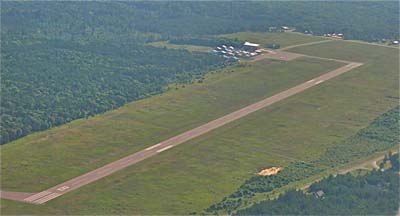
Facility Name: BLACK RIVER FALLS AREA
City Name: BLACK RIVER FALLS
County: JACKSON
State abbrev: WI
State Name: WISCONSIN
   
Ownership: PUBLICLY OWNED
Use: OPEN TO THE PUBLIC
Owner's Name: BLACK RIVER FALLS & JACKSON CO
Address: 101 S. SECOND ST
 BLACK RIVER FALLS, WI 54615
Owner's Phone: 715-284-5514
  
Manager's Name: DALE KLEVGARD
Address: 101 S. SECOND ST
 BLACK RIVER FALLS, WI 54615
Phone: (715) 896-9434
   
FAA Region: GREAT LAKES
FAA Field Office: CHI
Turning downwind for RWY26. Nancy Klevgard 2015.


Click here for full scale & interactive Sectional view of KBCK


Sunrise / Sunset times for BLACK RIVER FALLS AREA

DateSunriseSunset
04/18/24 Thursday6:1319:52
04/19/24 Friday6:1219:54
04/20/24 Saturday6:1019:55
04/21/24 Sunday6:0919:56
04/22/24 Monday6:0719:57
04/23/24 Tuesday6:0519:59
04/24/24 Wednesday6:0420:00
04/25/24 Thursday6:0220:01
04/26/24 Friday6:0120:02
04/27/24 Saturday5:5920:03
04/28/24 Sunday5:5820:05
04/29/24 Monday5:5620:06
04/30/24 Tuesday5:5520:07
05/01/24 Wednesday5:5320:08

Airport Facilities

Airport Attendance ScheduleUNATTENDED
Airport Status OPERATIONAL (This Status can change at any time - please check NOTAMS)
Airport Lighting ScheduleMIRL RWY 08/26 PRESET TO LOW SS-SR; TO INCR INTST & ACTVT REIL RWYS 08 & 26; PAPI RWYS 08 & 26 - CTAF.
Airport Storage AvailableTie Downs
Extra Services AvailableFlight Instruction
Wind IndicatorYES - (lighted)
Control TowerNO
CTAF Frequency122.900
Unicom Frequency
Rotating Beacon ColorWG
Segmented CircleNO
Landing FeeNO

Airport Inspection Data

Airport InspectedSTATE - performed by STATE AERONAUTICAL PERSONNEL
Inspection Date06/22/2022

Airport Services

Type of Fuel AvailableGrade 100LL, JET A (freeze point -40C); -1024 HOUR SELF-SERVE
Airframe Repair ServiceNONE
Power Plant Repair ServiceNONE

Geographic Data

LatitudeN4415.0
LongitudeW09051.3 (ESTIMATED)
Arpt Elevation836ft (SURVEYED)
Magnetic Variation00E
3 miles Sof BLACK RIVER FALLS
Traffic Pattern Altitude
Sectional ChartGREEN BAY

Aircraft Data

Operations (Reported)YearlyAvg. Daily
General Aviation Transient 4001
General Aviation Local 9002
Air Taxi 1000
Commerical 00
Commuter 00
Military 1000
Aircraft based on Field
General Aviation Singles 13
General Aviation Multi 1
Jet Aircraft 0
General Aviation Helicopters 0
Military Aircraft 0
Gliders 0
Ultralights 0

FAA Services

FSS on field NO
FSS tie-in GREEN BAY
FSS Phone 1-800-WX-BRIEF
Who issues Notams GRB
Notam D service at airport YES
ARTCC Name MINNEAPOLIS

Federal Status

Airport Certification
Aircraft Rescue & Firefighting IndexNone
Airport of EntryNo
Custom Landing RightsNo
Joint Civil/MilitaryNo
Military Landing rightsYES

Federal Agreements

NATIONAL PLAN OF INTEGRATED AIRPORT SYSTEMS (NPIAS)
ASSURANCES PURSUANT TO TITLE VI, CIVIL RIGHTS ACT OF 1964
GRANT AGREEMENT HAS EXPIRED; HOWEVER, AGREEMENT REMAINS IN EFFECT FOR THIS FACILITY AS LONG AS IT IS PUBLIC USE.

Remarks

WILDLIFE, BIRDS ON & INVOF ARPT.
FOR CD IF UNA TO CTC ON FSS FREQ, CTC MINNEAPOLIS ARTCC AT 651-463-5588.
Airport Communications & Frequencies:
CTAF Frequency:
122.900
Remarks
  • APCH/DEP SVC PRVDD BY MINNEAPOLIS ARTCC ON FREQS 128.6/363.0 (LA CROSSE RCAG).
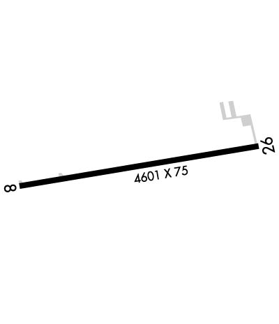
  • Runway Identifications
    Runway Identification: 08/26
    Length: 4601 ft
    Width: 75 ft
    Surface: ASPHALT-GOOD CONDITION
    Edge lights: Medium Intensity

    Treatment: NONE

     Runway: 08   Runway: 26
    Mag heading: 80°Mag heading: 260°
    Rwy Slope: .28% UpRwy Slope: -.28% Down
    Approach: Approach:
    Pattern: Left TrafficPattern: Left Traffic
    Markings: NONPRECISION INSTRUMENTMarkings: NONPRECISION INSTRUMENT
    Marking Condition: GOODMarking Condition: GOOD
    Arresting Dev: Arresting Dev:
    Lat & Long: N4415.0  W09051.8Lat. & Long.: N4415.1  W09050.8
    Elev: 823.2 ft. MSLElev: 836.2 ft. MSL
    TCH: 27 ft. AGLTCH: 27 ft. AGL
    Visual Glide Path: 3.00 degreesVisual Glide Path: 3.50 degrees
    Displaced Threshold: NoDisplaced Threshold: No
    Touchdown Zone: YESTouchdown Zone: YES
    Touchdown Elev.: 831.3 feetTouchdown Elev.: 836.2 feet
    Visual Glide Slope: 2-Light PAPI on LEFT side of Runway; VGSI AND RNAV GLIDEPATH NOT COINCIDENT.Visual Glide Slope: 2-Light PAPI on LEFT side of Runway; VGSI AND RNAV GLIDEPATH NOT COINCIDENT.
    RVR Equipment: RVR Equipment:
    RVV Equipment: NORVV Equipment: NO
    Approach Lights: Approach Lights:
    REIL: YESREIL: YES
    Centerline Lights: NOCenterline Lights: NO
    Touchdown lights: NOTouchdown lights: NO
    Runway Category: Runway with a Non-precision Approach having visibility minimums greater than 3/4 mileRunway Category: Runway with a Non-precision Approach having visibility minimums greater than 3/4 mile
    Declared Distances: Declared Distances:
    Obstructions: TREESObstructions: TREE
    Marked: NOT Marked/LightedMarked: NOT Marked/Lighted
    Clearance slope: 5:1Clearance slope: 26:1
    Obstruction height: 24 feet AGLObstruction height: 51 feet AGL
    Dist. from runway: 340 feetDist. from runway: 1526 feet
    Centerline offset: 254 left of centerlineCenterline offset: 260 feet right of centerline
    Comments: Comments:
    C:2/P: