Current Weather/Notams (Metars, TAFs, Notams, NWS Forecast, PIREPS, and nearby weather)
Customs Information Send updates to Support@FltPlan.com
Customs Not Available
Database effective 04/18/2024
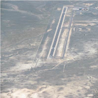
Airport Diagram might not be current.
|
| Facility Name: | BRYCE CANYON |
| City Name: | BRYCE CANYON |
| County: | GARFIELD |
| State abbrev: | UT |
| State Name: | UTAH |
| | |
| Ownership: | PUBLICLY OWNED |
| Use: | OPEN TO THE PUBLIC |
| Owner's Name: | GARFIELD COUNTY |
| Address: | 55 S MAIN ST., P.O. BOX 77 |
| | PANGUITCH, UT 84759 |
| Owner's Phone: | 435-676-8826 |
| | |
| Manager's Name: | TYE RAMSAY |
| Address: | 450 NORTH AIRPORT ROAD, PO BOX 640037 |
| | BRYCE, UT 84764 |
| Phone: | 435-834-5239 |
| | |
| FAA Region: | NORTHWEST MOUNTAIN |
| FAA Field Office: | DEN |
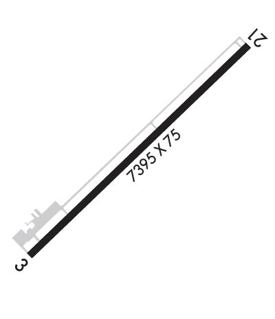
Runway Identifications
Runway Identification: 03/21Length: 7395 ft
Width: 75 ft
Surface: ASPHALT-GOOD CONDITION
Edge lights: Medium IntensityTreatment: POROUS FRICTION COURSE
| | Runway: 03 | | Runway: 21 |
| Mag heading: | 33° | Mag heading: | 213° |
| Rwy Slope: | -.49% Down | Rwy Slope: | .49% Up |
| Approach: | | Approach: | |
| Pattern: | Left Traffic | Pattern: | Left Traffic |
| Markings: | NONPRECISION INSTRUMENT | Markings: | NONPRECISION INSTRUMENT |
| Marking Condition: | FAIR | Marking Condition: | FAIR |
| Arresting Dev: | | Arresting Dev: | |
| Lat & Long: | N3742.0 W11209.3 | Lat. & Long.: | N3742.8 W11208.2 |
| Elev: | 7589.9 ft. MSL | Elev: | 7553.6 ft. MSL |
| TCH: | 44 ft. AGL | TCH: | 43 ft. AGL |
| Visual Glide Path: | 3.00 degrees | Visual Glide Path: | 3.00 degrees |
| Displaced Threshold: | No | Displaced Threshold: | No |
| Touchdown Zone: | YES | Touchdown Zone: | YES |
| Touchdown Elev.: | 7589.9 feet | Touchdown Elev.: | 7564.3 feet |
| Visual Glide Slope: | 2-Light PAPI on LEFT side of Runway | Visual Glide Slope: | 2-Light PAPI on LEFT side of Runway |
| RVR Equipment: | | RVR Equipment: | |
| RVV Equipment: | NO | RVV Equipment: | NO |
| Approach Lights: | | Approach Lights: | |
| REIL: | YES | REIL: | YES |
| Centerline Lights: | NO | Centerline Lights: | NO |
| Touchdown lights: | NO | Touchdown lights: | NO |
| Runway Category: | Runway with a Non-precision Approach having visibility minimums greater than 3/4 mile | Runway Category: | Runway with a Non-precision Approach having visibility minimums greater than 3/4 mile |
| Declared Distances: | | Declared Distances: | |
| Obstructions: | ROAD | Obstructions: | |
| Marked: | NOT Marked/Lighted | Marked: | |
| Clearance slope: | 30:1 | Clearance slope: | 50:1 |
| Obstruction height: | 13 feet AGL | Obstruction height: | |
| Dist. from runway: | 615 feet | Dist. from runway: | |
| Centerline offset: | 133B | Centerline offset: | |
| Comments: | | Comments: | |