
| ||||||||||||||||||||||||||||||||||||||||||||
| ||||||||||||||||||||||||||||||||||||||||||||
| ||||||||||||||||||||||||||||||||||||||||||||
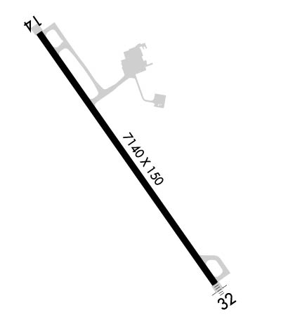
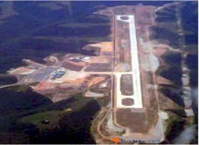
| Rwy | Rwy | |||||||
| 7140x150 | 7140' | 7140x150 | 7140' | 111.35 - 323° | ||||
| Runway ID | Single Wheel | Double Wheel | Double Tandem Wheel | Dual Double Wheel |
| 14/32 | 75,000 | 200,000 | 350,000 | 700,000 |
| These numbers are Advisory and are not limits. The Airport Manager should have more accurate Weight Limits | ||||
 Airport Diagram might not be current. | |
| Facility Name: | BRANSON |
| City Name: | BRANSON |
| County: | TANEY |
| State abbrev: | MO |
| State Name: | MISSOURI |
| Ownership: | PUBLICLY OWNED |
| Use: | OPEN TO THE PUBLIC |
| Owner's Name: | TANEY COUNTY; LEASED TO BRANSON RGNL ARPT TRNSPN DVLPTMT DIST. |
| Address: | 4000 BRANSON AIRPORT BLVD. |
| HOLLISTER, MO 65672 | |
| Owner's Phone: | 417-334-7813 |
| Manager's Name: | BRANSON AIRPORT, LLC- STANLEY FIELD |
| Address: | 4000 BRANSON AIRPORT BLVD. |
| HOLLISTER, MO 65672 | |
| Phone: | 417-334-7813 |
| FAA Region: | CENTRAL |
| FAA Field Office: | NONE |
| Date | Sunrise | Sunset |
|---|---|---|
| 04/24/24 Wednesday | 6:27 | 19:56 |
| 04/25/24 Thursday | 6:25 | 19:56 |
| 04/26/24 Friday | 6:24 | 19:57 |
| 04/27/24 Saturday | 6:23 | 19:58 |
| 04/28/24 Sunday | 6:22 | 19:59 |
| 04/29/24 Monday | 6:21 | 20:00 |
| 04/30/24 Tuesday | 6:20 | 20:01 |
| 05/01/24 Wednesday | 6:18 | 20:02 |
| 05/02/24 Thursday | 6:17 | 20:03 |
| 05/03/24 Friday | 6:16 | 20:03 |
| 05/04/24 Saturday | 6:15 | 20:04 |
| 05/05/24 Sunday | 6:14 | 20:05 |
| 05/06/24 Monday | 6:13 | 20:06 |
| 05/07/24 Tuesday | 6:12 | 20:07 |
| Airport Attendance Schedule | CONTINUOUS |
| Airport Status | OPERATIONAL (This Status can change at any time - please check NOTAMS) |
| Airport Lighting Schedule | WHEN ATCT CLSD: ACTVT MALSF RWY 32; REIL RWY 14; PAPI RWY 14 & 32; HIRL RWY 14/32 - CTAF. |
| Airport Storage Available | Tie Downs, Hanger |
| Extra Services Available | NONE |
| Wind Indicator | YES - (unlit) |
| Control Tower | YES |
| CTAF Frequency | 128.150 |
| Unicom Frequency | 122.950 |
| Rotating Beacon Color | WG |
| Segmented Circle | NO |
| Landing Fee |
| Airport Inspected | 5010-1 PUBLIC USE MAILOUT PROGRAM - performed by FAA AIRPORTS FIELD PERSONNEL |
| Inspection Date | 02/07/2023 |
| Type of Fuel Available | Grade 100LL, JET A (freeze point -40C), JET A; -10100LL CREDIT CARD SELF SVC AVBL H24 AT GA APRON. |
| Airframe Repair Service | None |
| Power Plant Repair Service | None |
| Latitude | N3631.9 |
| Longitude | W09312.0 (ESTIMATED) |
| Arpt Elevation | 1302ft (ESTIMATED) |
| Magnetic Variation | 02E |
| 8 miles SSE | of BRANSON |
| Traffic Pattern Altitude | |
| Sectional Chart | KANSAS CITY |
| Operations (Reported) | Yearly | Avg. Daily |
|---|---|---|
| General Aviation Transient | 6013 | 16 |
| General Aviation Local | 74 | 0 |
| Air Taxi | 1641 | 4 |
| Commerical | 44 | 0 |
| Commuter | 0 | 0 |
| Military | 1688 | 5 |
| Aircraft based on Field | |
|---|---|
| General Aviation Singles | 2 |
| General Aviation Multi | 1 |
| Jet Aircraft | 2 |
| General Aviation Helicopters | 0 |
| Military Aircraft | 0 |
| Gliders | 0 |
| Ultralights | 0 |
| FSS on field | NO |
| FSS tie-in | COLUMBIA |
| FSS Phone | 1-800-WX-BRIEF |
| Who issues Notams | BBG |
| Notam D service at airport | YES |
| ARTCC Name | KANSAS CITY |
| Airport Certification | AIRPORT RECEIVING SCHEDULED AIR CARRIER SERVICE FROM CARRIERS CERTIFICATED BY THE CIVIL AERONAUTICS BOARD; CLSD TO UNSKED ACR MORE THAN 30 PAX SEATS EXC 4 HR PPR - 417-334-8002. PPR ACR MORE THAN 15 MIN BFR OR AFT SKED ARR OR DEP - AMGR. |
| Aircraft Rescue & Firefighting Index | AIRPORT HAS A CERTIFICATE UNDER CFR PART 139 |
| Airport of Entry | No |
| Custom Landing Rights | No |
| Joint Civil/Military | No |
| Military Landing rights | No |
| HILLS & UNEVEN TRRN INVOF; TRRN AVOIDANCE MAY ACTVT ON FNL. |
| BIRDS INVOF ARPT. |
| RWY 32 CALM WIND RWY. |
Airport Communications & Frequencies:
| |||||||||||||||||||||||
| Runway: 14 | Runway: 32 | ||
| Mag heading: | 143° | Mag heading: | 323° |
| Rwy Slope: | .66% Up | Rwy Slope: | -.66% Down |
| Approach: | Approach: | ILS/DME | |
| Pattern: | Right Traffic | Pattern: | Left Traffic |
| Markings: | NONPRECISION INSTRUMENT | Markings: | PRECISION INSTRUMENT |
| Marking Condition: | GOOD | Marking Condition: | GOOD |
| Arresting Dev: | Arresting Dev: | ||
| Lat & Long: | N3632.4 W09312.5 | Lat. & Long.: | N3631.4 W09311.6 |
| Elev: | 1254.9 ft. MSL | Elev: | 1301.8 ft. MSL |
| TCH: | 51 ft. AGL | TCH: | 50 ft. AGL |
| Visual Glide Path: | 3.00 degrees | Visual Glide Path: | 3.00 degrees |
| Displaced Threshold: | No | Displaced Threshold: | No |
| Touchdown Zone: | YES | Touchdown Zone: | YES |
| Touchdown Elev.: | 1274.6 feet | Touchdown Elev.: | 1301.8 feet |
| Visual Glide Slope: | 4-Light PAPI on LEFT side of Runway | Visual Glide Slope: | 4-Light PAPI on LEFT side of Runway |
| RVR Equipment: | RVR Equipment: | ||
| RVV Equipment: | NO | RVV Equipment: | NO |
| Approach Lights: | Approach Lights: | MALSF - 1,400 foot medium intensity approach lighting system with sequenced flashers | |
| REIL: | YES | REIL: | NO |
| Centerline Lights: | NO | Centerline Lights: | NO |
| Touchdown lights: | NO | Touchdown lights: | NO |
| Runway Category: | Runway with a Non-precision Approach having visibility minimums greater than 3/4 mile | Runway Category: | Precision Instrument Runway |
| Declared Distances: | TORA:7140' TODA:7140' ASDA:7140' LDA:7140' | Declared Distances: | TORA:7140' TODA:7140' ASDA:7140' LDA:7140' |