Click here for more info on on SMS!

KBBB

BENSON MUNI
BENSON
MN
Time Zone: Central
Lat: N 4519.9
Long: W 09539.0
Elev: 1039
Var: -05
Longest Runway: 4000
AWOS: 118.45
CTAF: 122.8

FBO & Flight Services info for KBBB

FBOs: Update your Fuel Prices

BENSON MUNIPh: 320-843-4880
-
Freq: 122.8
Service
Jet
100LL
SAF
MoGas
Fuel Avail: 24/7 Fuel Pump located behind Yellow Shed. Use north roll up door and 2 pump!
Full        Caution: Fuel prices have not been updated in 32 days.
Last Update: 03/22/2024 13:44

Self7.076.01    
 Address: 340 20TH ST NW,   BENSON, MN 56215
AWOSPh: 320-843-3242
-
Freq: 118.45  
If you are an FBO, call 1-203-262-1700 to update your info or email: FltPlan.Advertising@garmin.com
Advertise your FBO on FltPlan.com

Runway & Approach Info for KBBB
Rwy
Length
Land Dist**
Approach*
  Rwy
Length
Land Dist**
Approach*
14
4000x75  4000'          
 
  
32
  4000x75  4000'          
 
 * only ILS, LOC, LDA, and SDF approaches to a specific runway are shown
** For any Declared Landing Distance Available, please see A/FD or Approach plates
Runway Weight Capability (lbs.) Help
Runway IDSingle WheelDouble WheelDouble Tandem WheelDual Double Wheel
14/3240,00050,000N/AN/A
These numbers are Advisory and are not limits.   The Airport Manager should have more accurate Weight Limits
Approach Charts
Approaches    
Current Weather/Notams
Customs Information Send updates to Support@FltPlan.com
Customs Not Available
Database effective 05/16/2024
Airport Diagram of KBBB
Airport Diagram might not be current.

Facility Name: BENSON MUNI
City Name: BENSON
County: SWIFT
State abbrev: MN
State Name: MINNESOTA
   
Ownership: PUBLICLY OWNED
Use: OPEN TO THE PUBLIC
Owner's Name: CITY OF BENSON
Address: 1410 KANSAS AVE
 BENSON, MN 56215
Owner's Phone: 320-843-4775
  
Manager's Name: DAN GENS
Address: 1410 KANSAS AVE
 BENSON, MN 56215
Phone: (320) 368-2703
   
FAA Region: GREAT LAKES
FAA Field Office: DMA


Sunrise / Sunset times for BENSON MUNI

DateSunriseSunset
04/22/24 Monday6:2420:19
04/23/24 Tuesday6:2220:20
04/24/24 Wednesday6:2120:21
04/25/24 Thursday6:1920:22
04/26/24 Friday6:1820:24
04/27/24 Saturday6:1620:25
04/28/24 Sunday6:1420:26
04/29/24 Monday6:1320:27
04/30/24 Tuesday6:1120:29
05/01/24 Wednesday6:1020:30
05/02/24 Thursday6:0820:31
05/03/24 Friday6:0720:32
05/04/24 Saturday6:0620:34
05/05/24 Sunday6:0420:35

Airport Facilities

Airport Attendance ScheduleUNATTENDED
Airport Status OPERATIONAL (This Status can change at any time - please check NOTAMS)
Airport Lighting ScheduleMIRL RY 14/32 PRESET LOW INTST TO INCR INTST AND ACTVT REIL RY 14/32; PAPI RY 14//32; MIRL RY 14/32 - CTAF.
Airport Storage AvailableTie Downs, Hanger
Extra Services AvailableCrop Dusting, Aircraft Sales
Wind IndicatorYES - (lighted)
Control TowerNO
CTAF Frequency122.800
Unicom Frequency122.800
Rotating Beacon ColorWG
Segmented CircleYES
Landing FeeNO

Airport Inspection Data

Airport InspectedSTATE - performed by STATE AERONAUTICAL PERSONNEL
Inspection Date07/19/2023

Airport Services

Type of Fuel AvailableGrade 100LL, JET A (freeze point -40C); -10SELF SERVE FUEL AVAIL 24 HRS WITH CREDIT CARD.
Airframe Repair ServiceMINOR
Power Plant Repair ServiceMINOR

Geographic Data

LatitudeN4519.9
LongitudeW09539.0 (ESTIMATED)
Arpt Elevation1039ft (SURVEYED)
Magnetic Variation05E
2 miles Wof BENSON
Traffic Pattern Altitude
Sectional ChartTWIN CITIES

Aircraft Data

Operations (Reported)YearlyAvg. Daily
General Aviation Transient 20005
General Aviation Local 30008
Air Taxi 1000
Commerical 00
Commuter 00
Military 00
Aircraft based on Field
General Aviation Singles 25
General Aviation Multi 1
Jet Aircraft 0
General Aviation Helicopters 1
Military Aircraft 0
Gliders 0
Ultralights 0

FAA Services

FSS on field NO
FSS tie-in PRINCETON
FSS Phone 1-800-WX-BRIEF
Who issues Notams BBB
Notam D service at airport YES
ARTCC Name MINNEAPOLIS

Federal Status

Airport Certification
Aircraft Rescue & Firefighting IndexNone
Airport of EntryNo
Custom Landing RightsNo
Joint Civil/MilitaryNo
Military Landing rightsYES

Federal Agreements

NATIONAL PLAN OF INTEGRATED AIRPORT SYSTEMS (NPIAS)
GRANT AGREEMENTS UNDER FAAP/ADAP/AIP
ASSURANCES PURSUANT TO TITLE VI, CIVIL RIGHTS ACT OF 1964

Remarks

CATEGORY 'C' & 'D' ACFT OPNS PROHIBITED.
FOR CD CTC MINNEAPOLIS ARTCC AT 651-463-5588.
Airport Communications & Frequencies:
CTAF Frequency:
122.800
Unicom Frequency:
122.800
Remarks
  • APCH/DEP SVC PRVDD BY MINNEAPOLIS ARTCC ON FREQS 125.5/323.1 (DARWIN RCAG).
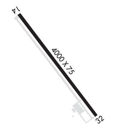
  • Runway Identifications
    Runway Identification: 14/32
    Length: 4000 ft
    Width: 75 ft
    Surface: ASPHALT-FAIR CONDITION
    Edge lights: Medium Intensity

    Treatment: NONE

     Runway: 14   Runway: 32
    Mag heading: 139°Mag heading: 319°
    Rwy Slope: .00% UpRwy Slope: .00% Down
    Approach: Approach:
    Pattern: Right TrafficPattern: Left Traffic
    Markings: NONPRECISION INSTRUMENTMarkings: NONPRECISION INSTRUMENT
    Marking Condition: FAIRMarking Condition: FAIR
    Arresting Dev: Arresting Dev:
    Lat & Long: N4520.2  W09539.3Lat. & Long.: N4519.7  W09538.8
    Elev: 1038.5 ft. MSLElev: 1038.6 ft. MSL
    TCH: 40 ft. AGLTCH: 41 ft. AGL
    Visual Glide Path: 3.00 degreesVisual Glide Path: 3.00 degrees
    Displaced Threshold: NoDisplaced Threshold: No
    Touchdown Zone: YESTouchdown Zone: YES
    Touchdown Elev.: 1039.3 feetTouchdown Elev.: 1039.3 feet
    Visual Glide Slope: 4-Light PAPI on LEFT side of Runway; RY 14 PAPI UNUSEABLE BYD 2 NM.Visual Glide Slope: 4-Light PAPI on LEFT side of Runway
    RVR Equipment: RVR Equipment:
    RVV Equipment: NORVV Equipment: NO
    Approach Lights: Approach Lights:
    REIL: YESREIL: YES
    Centerline Lights: NOCenterline Lights: NO
    Touchdown lights: NOTouchdown lights: NO
    Runway Category: Runway with a Non-precision Approach having visibility minimums greater than 3/4 mileRunway Category: Runway with a Non-precision Approach having visibility minimums greater than 3/4 mile
    Declared Distances: Declared Distances:
    Obstructions: BRUSHObstructions: TREES
    Marked: NOT Marked/LightedMarked: NOT Marked/Lighted
    Clearance slope: 19:1Clearance slope: 17:1
    Obstruction height: 7 feet AGLObstruction height: 33 feet AGL
    Dist. from runway: 334 feetDist. from runway: 773 feet
    Centerline offset: 139 right of centerlineCenterline offset: 221 feet right of centerline
    Comments: Comments:
    C:/P: