Current Weather/Notams (Metars, TAFs, Notams, NWS Forecast, PIREPS, and nearby weather)
Customs Information Send updates to Support@FltPlan.com
Customs Not Available
Database effective 05/16/2024
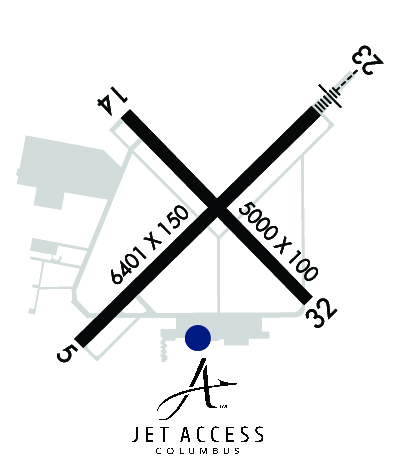
Airport Diagram might not be current. Facility Name: COLUMBUS MUNI City Name: COLUMBUS County: BARTHOLOMEW State abbrev: IN State Name: INDIANA Ownership: PUBLICLY OWNED Use: OPEN TO THE PUBLIC Owner's Name: CITY OF COLUMBUS Address: 4770 RAY BOLL BLVD COLUMBUS, IN 47203 Owner's Phone: 812-376-2519 Manager's Name: BRIAN PAYNE Address: 4770 RAY BOLL BLVD COLUMBUS, IN 47203 Phone: 812-376-2519; 812-379-9942 FAA Region: GREAT LAKES FAA Field Office: CHI
Runway Identifications Help
Runway Identification: 05/23 Length: 6401 ftWidth: 150 ftSurface: CONCRETEEdge lights: High Intensity Treatment: GROOVEDWeight: PCN 56 /R/B/W/T Runway: 05 Runway: 23 Mag heading: 48° Mag heading: 228° Rwy Slope: .09% Up Rwy Slope: -.09% Down Approach: Approach: ILS Pattern: Left Traffic Pattern: Left Traffic Markings: PRECISION INSTRUMENT Markings: PRECISION INSTRUMENT Marking Condition: GOOD Marking Condition: GOOD Arresting Dev: Arresting Dev: Lat & Long: N3915.3 W08554.3 Lat. & Long.: N3916.1 W08553.3 Elev: 650.3 ft. MSL Elev: 656.0 ft. MSL TCH: 50 ft. AGL TCH: 52 ft. AGL Visual Glide Path: 3.00 degrees Visual Glide Path: 3.00 degrees Displaced Threshold: No Displaced Threshold: No Touchdown Zone: YES Touchdown Zone: YES Touchdown Elev.: 652.5 feet Touchdown Elev.: 656.1 feet Visual Glide Slope: 4-Light PAPI on LEFT side of Runway Visual Glide Slope: 4-Light PAPI on LEFT side of Runway RVR Equipment: RVR Equipment: RVV Equipment: NO RVV Equipment: NO Approach Lights: Approach Lights: MALSR - 1,400 foot medium intensity approach lighting system with runway alignment indicator lights REIL: YES REIL: NO Centerline Lights: NO Centerline Lights: NO Touchdown lights: NO Touchdown lights: NO Runway Category: Runway with a Non-precision Approach having visibility minimums greater than 3/4 mile Runway Category: Precision Instrument Runway Declared Distances: TORA:6401' TODA:6401' ASDA:6401' LDA:6401' Declared Distances: TORA:6401' TODA:6401' ASDA:6401' LDA:6401' Obstructions: TOWER Obstructions: Marked: NOT Marked/Lighted Marked: Clearance slope: 38:1 Clearance slope: 50:1 Obstruction height: 74 feet AGL Obstruction height: Dist. from runway: 3040 feet Dist. from runway: Centerline offset: 94 right of centerline Centerline offset: Comments: Comments:
Runway Identification: 14/32 Length: 5000 ftWidth: 100 ftSurface: CONCRETEEdge lights: Medium Intensity Treatment: GROOVEDWeight: PCN 48 /R/B/W/T Runway: 14 Runway: 32 Mag heading: 138° Mag heading: 318° Rwy Slope: -.06% Down Rwy Slope: .06% Up Approach: Approach: Pattern: Left Traffic Pattern: Left Traffic Markings: NONPRECISION INSTRUMENT Markings: NONPRECISION INSTRUMENT Marking Condition: GOOD Marking Condition: GOOD Arresting Dev: Arresting Dev: Lat & Long: N3916.0 W08554.1 Lat. & Long.: N3915.5 W08553.4 Elev: 654.5 ft. MSL Elev: 651.5 ft. MSL TCH: 45 ft. AGL TCH: 45 ft. AGL Visual Glide Path: 3.00 degrees Visual Glide Path: 3.00 degrees Displaced Threshold: No Displaced Threshold: No Touchdown Zone: YES Touchdown Zone: YES Touchdown Elev.: 654.6 feet Touchdown Elev.: 653.2 feet Visual Glide Slope: 4-Light PAPI on LEFT side of Runway Visual Glide Slope: 4-Light PAPI on LEFT side of Runway RVR Equipment: RVR Equipment: RVV Equipment: NO RVV Equipment: NO Approach Lights: Approach Lights: REIL: YES REIL: YES Centerline Lights: NO Centerline Lights: NO Touchdown lights: NO Touchdown lights: NO Runway Category: Runway with a Non-precision Approach having visibility minimums greater than 3/4 mile Runway Category: Runway with a Non-precision Approach having visibility minimums greater than 3/4 mile Declared Distances: TORA:5000' TODA:5000' ASDA:5000' LDA:5000' Declared Distances: TORA:5000' TODA:5000' ASDA:5000' LDA:5000'