
| ||||||
|
| Rwy | Rwy | |||||||
| 11758x299 | 11758' | 108.90 - 147° | 11758x299 | 11758' | 109.90 - 329° | |||
| Runway ID | Single Wheel | Double Wheel | Double Tandem Wheel | Dual Double Wheel |
| 15/33 | N/A | N/A | N/A | N/A |
| These numbers are Advisory and are not limits. The Airport Manager should have more accurate Weight Limits | ||||
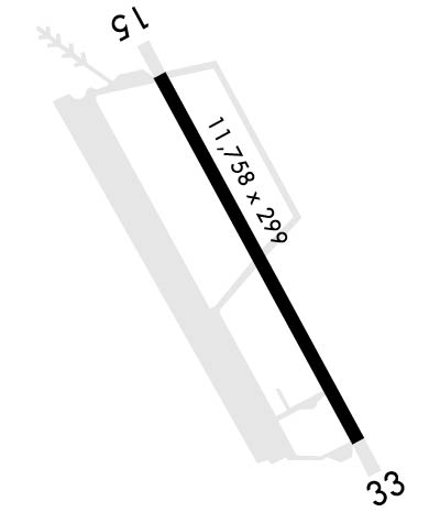 Airport Diagram might not be current. | |
| Facility Name: | BARKSDALE AFB |
| City Name: | BOSSIER CITY |
| County: | BOSSIER |
| State abbrev: | LA |
| State Name: | LOUISIANA |
| Ownership: | AIR FORCE OWNED |
| Use: | PRIVATE |
| Owner's Name: | USAF |
| Address: | BARKSDALE AFB |
| SHREVEPORT, LA 71110 | |
| Owner's Phone: | |
| Manager's Name: | BASE COMMANDER |
| Address: | BARKSDALE AFB |
| SHREVEPORT, LA 71110 | |
| Phone: | 318-456-3226; ALT #'S 2707/0158. |
| FAA Region: | SOUTHWEST |
| FAA Field Office: | LNM |
| Date | Sunrise | Sunset |
|---|---|---|
| 04/24/24 Wednesday | 6:34 | 19:52 |
| 04/25/24 Thursday | 6:33 | 19:52 |
| 04/26/24 Friday | 6:32 | 19:53 |
| 04/27/24 Saturday | 6:31 | 19:54 |
| 04/28/24 Sunday | 6:30 | 19:54 |
| 04/29/24 Monday | 6:29 | 19:55 |
| 04/30/24 Tuesday | 6:28 | 19:56 |
| 05/01/24 Wednesday | 6:27 | 19:57 |
| 05/02/24 Thursday | 6:26 | 19:57 |
| 05/03/24 Friday | 6:25 | 19:58 |
| 05/04/24 Saturday | 6:24 | 19:59 |
| 05/05/24 Sunday | 6:24 | 19:59 |
| 05/06/24 Monday | 6:23 | 20:00 |
| 05/07/24 Tuesday | 6:22 | 20:01 |
| Airport Attendance Schedule | CONTINUOUS |
| Airport Status | OPERATIONAL (This Status can change at any time - please check NOTAMS) |
| Airport Lighting Schedule | SS-SR |
| Airport Storage Available | NONE |
| Extra Services Available | Cargo Handling |
| Wind Indicator | YES - (unlit) |
| Control Tower | YES |
| CTAF Frequency | |
| Unicom Frequency | |
| Rotating Beacon Color | SWG |
| Segmented Circle | NO |
| Landing Fee | NO |
| Airport Inspected | No Inspection Data Available performed by the OWNER |
| Inspection Date | Unknown |
| Type of Fuel Available | ++ |
| Airframe Repair Service | MAJOR |
| Power Plant Repair Service | MAJOR |
| Latitude | N3230.1 |
| Longitude | W09339.8 (ESTIMATED) |
| Arpt Elevation | 165ft (SURVEYED) |
| Magnetic Variation | 02E |
| 3 miles E | of BOSSIER CITY |
| Traffic Pattern Altitude | |
| Sectional Chart | MEMPHIS |
| Operations (Reported) | Yearly | Avg. Daily |
|---|---|---|
| General Aviation Transient | 0 | 0 |
| General Aviation Local | 0 | 0 |
| Air Taxi | 0 | 0 |
| Commerical | 0 | 0 |
| Commuter | 0 | 0 |
| Military | 0 | 0 |
| Aircraft based on Field | |
|---|---|
| General Aviation Singles | 0 |
| General Aviation Multi | 0 |
| Jet Aircraft | 0 |
| General Aviation Helicopters | 0 |
| Military Aircraft | 2 |
| Gliders | 0 |
| Ultralights | 0 |
| FSS on field | NO |
| FSS tie-in | DE RIDDER |
| FSS Phone | 1-800-WX-BRIEF |
| Who issues Notams | DRI |
| Notam D service at airport | YES |
| ARTCC Name | FORT WORTH |
| Airport Certification | |
| Aircraft Rescue & Firefighting Index | None |
| Airport of Entry | No |
| Custom Landing Rights | No |
| Joint Civil/Military | No |
| Military Landing rights | No |
| RSTD: TWYS E & E1 UNLGTD & USABLE FOR DAYLT VFR ONLY. |
| BEARING STRENGTH RWY 15-33: ST175, AUW800 |
| A-GEAR - BAK-12B AVBL UPON REQ 1 HR PRIOR. W SIDE A-GEAR MRK PERM REMOVED. MP EVERY THIRD FRI FR 1200-1400Z++. |
| JASU - 1(MA-1A) 7(A/M32A-86) 1(A/M32A-95) 1(A/M32A-60). |
| FLUID - W SP PRESAIR LHOX LOX. |
| OIL - O-132-133-148-156 JOAP. |
| TRAN ALERT - NO PRIORITY BASIS. EXP SVC DELAYS OF 2 HR OR MORE. LTD FLEET SVC AVBL. POTABLE WATER UNAVBL. |
| RSTD: 180 DEG TURNS FOR C135 AND HVY ACFT ARE AUTH IN THE FIRST 750 FT RWY 15 AND THE FIRST 1000 FT RWY 33. |
| RSTD: PPR ISSUED UP TO 7 DAYS PRIOR TO ARR. PPR GOOD FOR +/- 15 MIN PPR TIME. COORD OF PPR OUTSIDE OF BLOCK TIME BY FONE IS RQR OR PPR NR WILL BE CONSIDERED CNL. |
| TFC PAT - RECTANGULAR 1200 FT, OVERHEAD 1700 FT. VFR COPTER ENTER TFC PAT AT 700 FT FM E AND 1000 FT FM W. OVFT OF MUNITIONS STOR AREA E-NE OF FLD NOT AUTH. |
| MISC: ACFT WITH DV CTC PTD OR COMD POST AT LEAST 20 MIN PRIOR TO ETA. |
| RSTD: TRAN ACFT WITH ORDNANCE NOT AUTH. |
| RSTD: TRNG FOR TRAN AIRCREWS WILL NOT BE PERMS TO INTERFERE WITH LCL ACFT OPR. NON-AFGSC ACFT MAY BE SUBJECTED TO LESS THAN RQR QUANTITY-DISTANCE SEPARATION DUE MUNITIONS OPR. AIRCREWS SHOULD EXER APPROPRIATE RISK MANAGEMENT IN DETERMINING AFLD SUITABILITY. ALL TRAN AIRCREWS MUST RPT TO BASE OPS. |
| CAUTION - LGT ACFT AND PRCHT OPS INVOF SHREVEPORT DOWNTOWN 3.3 NM NW DUR FINAL APCH RWY 15 AND DEP RWY 33. |
| SERVICE - TRAN ALERT: TRAN MAINT SVC HR 1400-0100Z++ MON-FRI; 1400-2400Z++ SAT-SUN; CLSD HOL. |
| SERVICE-LGT: RWY 15 ALSF-1 NSTD CONFIGN - DIST FM THR LGT TO PRE-THR LGT IS 128 FT; PRE-THR LGT TO TERM BAR IS 128 FT. |
| MISC: NSTD SPACING OF 150 FT BTN RWY 15 & 33 OVERRUN MRKS. |
| ALL TRANS AIRCREWS MUST REPORT TO AIRFIELD OPS. |
| RSTD: TWY C UNLGTD, OPEN TO ALL ACFT FOR DAYTIME OPS ONLY EXE FOR B-52. |
| MISC: USAF AFLD MGMT PERS DO NOT DETERMINE/RPT A RWY COND CODE (RWYCC) NOR ISSUE FAA FORMATTED FLD COND NOTAM (FICON). |
| MISC: AFLD OPS UNA TO ISSUE COMSEC AND HAS NO STORAGE CAPABILITY. |
| OPR 1200Z-0630Z++MON-FRI 1400Z-2200Z++WKENDS; CLSD AFGSC FAMILY DAYS AND FED HOL. |
| WX DSN 781-3136 OR C318-456-3136. |
| RWY 15/3 3 FIRST 1184 FT RWY 15 AND FIRST 1600 FT RWY 33 CONCRETE. MIDDLE 8972 FT ASPHALT WITH FIRST 3000 FT AT EACH END HAVING A 75 FT WIDE CONCRETE KEEL SFC IN CNTR AND THE MID 2972 FT HAVING A 50 FT CONCRETE KEEL SFC. |
Airport Communications & Frequencies:
| |||||||||||||||||||||||||||||||||||||||||||
| Runway: 15 | Runway: 33 | ||
| Mag heading: | 149° | Mag heading: | 329° |
| Rwy Slope: | -.02% Down | Rwy Slope: | .02% Up |
| Approach: | ILS | Approach: | ILS |
| Pattern: | Left Traffic | Pattern: | Left Traffic |
| Markings: | PRECISION INSTRUMENT | Markings: | PRECISION INSTRUMENT |
| Marking Condition: | GOOD | Marking Condition: | GOOD |
| Arresting Dev: | Arresting Dev: | BAK-12; BAK-12(B) (1102'). | |
| Lat & Long: | N3231.0 W09340.3 | Lat. & Long.: | N3229.3 W09339.2 |
| Elev: | 163.0 ft. MSL | Elev: | 160.8 ft. MSL |
| TCH: | 53 ft. AGL | TCH: | 50 ft. AGL |
| Visual Glide Path: | 2.50 degrees | Visual Glide Path: | 2.50 degrees |
| Displaced Threshold: | No | Displaced Threshold: | No |
| Touchdown Zone: | YES | Touchdown Zone: | YES |
| Touchdown Elev.: | 165.2 feet | Touchdown Elev.: | 162.5 feet |
| Visual Glide Slope: | 4-Light PAPI on LEFT side of Runway | Visual Glide Slope: | 4-Light PAPI on LEFT side of Runway |
| RVR Equipment: | TOUCHDOWN | RVR Equipment: | TOUCHDOWN |
| RVV Equipment: | YES | RVV Equipment: | YES |
| Approach Lights: | ALSF1 - standard 2,400 foot high intensity approach lighting system with sequenced flashers, Category I | Approach Lights: | ALSF1 - standard 2,400 foot high intensity approach lighting system with sequenced flashers, Category I |
| REIL: | YES | REIL: | YES |
| Centerline Lights: | NO | Centerline Lights: | NO |
| Touchdown lights: | NO | Touchdown lights: | NO |
| Runway Category: | Precision Instrument Runway | Runway Category: | Precision Instrument Runway |
| Declared Distances: | Declared Distances: |
