Current Weather/Notams (Metars, TAFs, Notams, NWS Forecast, PIREPS, and nearby weather)
Customs Information Send updates to Support@FltPlan.com
Customs Not Available
Database effective 05/16/2024
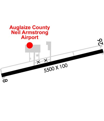
Airport Diagram might not be current. Facility Name: NEIL ARMSTRONG City Name: WAPAKONETA County: AUGLAIZE State abbrev: OH State Name: OHIO Ownership: PUBLICLY OWNED Use: OPEN TO THE PUBLIC Owner's Name: AUGLAIZE CO ARPT AUTH Address: PO BOX 400 NEW KNOXVILLE, OH 45871-0400 Owner's Phone: 419-753-2810 Manager's Name: TED BERGSTROM Address: PO BOX 400 NEW KNOXVILLE, OH 45871-0400 Phone: 419-753-2810 FAA Region: GREAT LAKES FAA Field Office: DET
Runway Identifications Help
Runway Identification: 08/26 Length: 5500 ftWidth: 100 ftSurface: ASPHALT-GOOD CONDITIONEdge lights: Medium Intensity Treatment: GROOVED Runway: 08 Runway: 26 Mag heading: 81° Mag heading: 261° Rwy Slope: .01% Up Rwy Slope: -.01% Down Approach: Approach: LOC/DME Pattern: Left Traffic Pattern: Left Traffic Markings: NONPRECISION INSTRUMENT Markings: NONPRECISION INSTRUMENT Marking Condition: GOOD Marking Condition: GOOD Arresting Dev: Arresting Dev: Lat & Long: N4029.5 W08418.5 Lat. & Long.: N4029.7 W08417.3 Elev: 907.7 ft. MSL Elev: 908.0 ft. MSL TCH: 50 ft. AGL TCH: 40 ft. AGL Visual Glide Path: 4.00 degrees Visual Glide Path: 3.00 degrees Displaced Threshold: 698 feet Displaced Threshold: 237 feet Touchdown Zone: YES Touchdown Zone: YES Touchdown Elev.: 912.3 feet Touchdown Elev.: 909.7 feet Visual Glide Slope: 4-Light PAPI on LEFT side of Runway Visual Glide Slope: 4-Light PAPI on LEFT side of Runway RVR Equipment: RVR Equipment: RVV Equipment: NO RVV Equipment: NO Approach Lights: Approach Lights: REIL: YES REIL: YES Centerline Lights: NO Centerline Lights: NO Touchdown lights: NO Touchdown lights: NO Runway Category: Runway with a Non-precision Approach Runway Category: Runway with a Non-precision Approach Declared Distances: Declared Distances: Obstructions: TREES Obstructions: ROAD Marked: NOT Marked/Lighted Marked: NOT Marked/Lighted Clearance slope: 3:1; APCH SLP 13:1 TO DTHR DUE TO +89 FT TREE, 1179 FT DIST, 248 FT L. Clearance slope: 8:1; APCH SLP 37:1 TO DTHR DUE TO +15 FT ROAD, 567 FT DIST, 275 FT R. Obstruction height: 89 feet AGL Obstruction height: 15 feet AGL Dist. from runway: 479 feet Dist. from runway: 330 feet Centerline offset: 248 left of centerline Centerline offset: 275 feet right of centerline Comments: 3 FT CROPS, 0-70 FT DIST, 200 FT R. Comments: 8 FT TRRN, 0-40 FT DIST, 190 FT L; 8 FT FENCE, 65-200 FT DIST, 220-230 FT L.