Click here for more info on on SMS!

KAXQ

CLARION COUNTY
CLARION
PA
Time Zone: Eastern
Lat: N 4113.5
Long: W 07926.5
Elev: 1458
Var: +10
Longest Runway: 5003
AWOS: 118.27
CTAF: 122.8

FBO & Flight Services info for KAXQ

FBOs: Update your Fuel Prices
If you are planning a fuel stop while flying in Western Pennsylvania, consider paying us a visit. Our prices are some of the lowest in the state. We can have you fueled and taxiing out to the runway in about 10 minutes. Our current hours of operation are Monday- Saturday 8:00AM-4:00PM Sundays Unattended.
Ph: 814-226-9993
-
Freq: 122.8WebsiteE-Mail
Service
Jet
100LL
SAF
MoGas
Fuel Avail: PRIST PREMIXED. 24/7 self serve, full serve 0800-1600 7 days
Full        Last Update: 04/20/2024 16:30

Self5.756.89    
Misc. Info: Cash discount, quantity discount, Oshkosh and Angel Flight discount, Taxi/Car Rental 814-226-8635Address: 395 AIRPORT RD   SHIPPENVILLE ,PA 16254

AWOSPh: 814-227-2899
-
Freq: 118.27  
If you are an FBO, call 1-203-262-1700 to update your info or email: FltPlan.Advertising@garmin.com
Advertise your FBO on FltPlan.com

Runway & Approach Info for KAXQ
Rwy
Length
Land Dist**
Approach*
  Rwy
Length
Land Dist**
Approach*
06
5003x75  5003'          
 
  
24
  5003x75  5003'          
 
 * only ILS, LOC, LDA, and SDF approaches to a specific runway are shown
** For any Declared Landing Distance Available, please see A/FD or Approach plates
Runway Weight Capability (lbs.) Help
Runway IDSingle WheelDouble WheelDouble Tandem WheelDual Double Wheel
06/2415,000N/AN/AN/A
These numbers are Advisory and are not limits.   The Airport Manager should have more accurate Weight Limits
Approach Charts
Approaches    
Current Weather/Notams
Customs Information Send updates to Support@FltPlan.com
Customs Not Available
Database effective 05/16/2024
Airport Diagram of KAXQ
Airport Diagram might not be current.

Facility Name: CLARION COUNTY
City Name: CLARION
County: CLARION
State abbrev: PA
State Name: PENNSYLVANIA
   
Ownership: PUBLICLY OWNED
Use: OPEN TO THE PUBLIC
Owner's Name: CLARION COUNTY ARPT AUTH
Address: 395 AIRPORT RD
 SHIPPENVILLE, PA 16254
Owner's Phone: 814-226-9993
  
Manager's Name: DONALD KIMBALL
Address: 395 AIRPORT ROAD
 SHIPPENVILLE, PA 16254
Phone: (814) 226-9993; AFT HRS CALL (814) 316-5746.
   
FAA Region: EASTERN
FAA Field Office: HAR


Sunrise / Sunset times for CLARION COUNTY

DateSunriseSunset
04/24/24 Wednesday6:2420:08
04/25/24 Thursday6:2220:09
04/26/24 Friday6:2120:10
04/27/24 Saturday6:2020:12
04/28/24 Sunday6:1820:13
04/29/24 Monday6:1720:14
04/30/24 Tuesday6:1620:15
05/01/24 Wednesday6:1420:16
05/02/24 Thursday6:1320:17
05/03/24 Friday6:1220:18
05/04/24 Saturday6:1120:19
05/05/24 Sunday6:0920:20
05/06/24 Monday6:0820:21
05/07/24 Tuesday6:0720:22

Airport Facilities

Airport Attendance ScheduleMON-SAT 0800-1600; UNATTENDED CHRISTMAS, EASTER & THANKSGIVING.
Airport Status OPERATIONAL (This Status can change at any time - please check NOTAMS)
Airport Lighting ScheduleACTVT MIRL RY 06/24, REIL RYS 06 & 24 AND PAPI RYS 06 & 24 - CTAF.
Airport Storage AvailableTie Downs, Hanger
Extra Services AvailableFlight Instruction, Aircraft Rental
Wind IndicatorYES - (lighted)
Control TowerNO
CTAF Frequency122.800
Unicom Frequency122.800
Rotating Beacon ColorWG
Segmented CircleNO
Landing FeeYES

Airport Inspection Data

Airport InspectedSTATE - performed by STATE AERONAUTICAL PERSONNEL
Inspection Date08/30/2023

Airport Services

Type of Fuel AvailableGrade 100LL, JET A; -10SINGLE POINT REFUELING AVAILABLE UPON REQUEST.
Airframe Repair ServiceNone
Power Plant Repair ServiceNone

Geographic Data

LatitudeN4113.5
LongitudeW07926.5 (ESTIMATED)
Arpt Elevation1457ft (SURVEYED)
Magnetic Variation10W
3 miles NWof CLARION
Traffic Pattern Altitude
Sectional ChartDETROIT

Aircraft Data

Operations (Reported)YearlyAvg. Daily
General Aviation Transient 12683
General Aviation Local 14784
Air Taxi 00
Commerical 00
Commuter 00
Military 300
Aircraft based on Field
General Aviation Singles 9
General Aviation Multi 0
Jet Aircraft 0
General Aviation Helicopters 3
Military Aircraft 0
Gliders 0
Ultralights 0

FAA Services

FSS on field NO
FSS tie-in ALTOONA
FSS Phone 1-800-WX-BRIEF
Who issues Notams AOO
Notam D service at airport YES
ARTCC Name CLEVELAND

Federal Status

Airport Certification
Aircraft Rescue & Firefighting IndexNone
Airport of EntryNo
Custom Landing RightsNo
Joint Civil/MilitaryNo
Military Landing rightsYES

Federal Agreements

NATIONAL PLAN OF INTEGRATED AIRPORT SYSTEMS (NPIAS)
GRANT AGREEMENTS UNDER FAAP/ADAP/AIP
ADVANCE PLANNING AGREEMENT UNDER FAAP
ASSURANCES PURSUANT TO TITLE VI, CIVIL RIGHTS ACT OF 1964

Remarks

THIS AIRPORT HAS BEEN SURVEYED BY THE NATIONAL GEODETIC SURVEY.
FOR CD CTC CLEVELAND ARTCC AT 440-774-0234/0442.
Airport Communications & Frequencies:
CTAF Frequency:
122.800
Unicom Frequency:
122.800
Remarks
  • APCH/DEP SVC PRVDD BY CLEVELAND ARTCC (ZOB) ON FREQS 126.725/291.65 (DUBOIS RCAG).
  • Runway Identifications
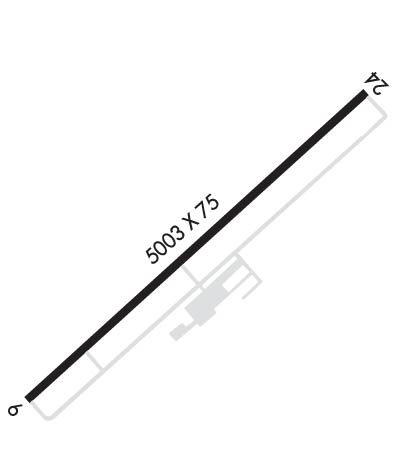
    Runway Identification: 06/24
    Length: 5003 ft
    Width: 75 ft
    Surface: ASPHALT-GOOD CONDITION
    Edge lights: Medium Intensity

    Treatment: NONE

     Runway: 06   Runway: 24
    Mag heading: 55°Mag heading: 235°
    Rwy Slope: .49% UpRwy Slope: -.49% Down
    Approach: Approach:
    Pattern: Left TrafficPattern: Left Traffic
    Markings: NONPRECISION INSTRUMENTMarkings: NONPRECISION INSTRUMENT
    Marking Condition: GOODMarking Condition: GOOD
    Arresting Dev: Arresting Dev:
    Lat & Long: N4113.2  W07926.9Lat. & Long.: N4113.8  W07926.1
    Elev: 1433.1 ft. MSLElev: 1457.4 ft. MSL
    TCH: 40 ft. AGLTCH: 40 ft. AGL
    Visual Glide Path: 3.00 degreesVisual Glide Path: 3.00 degrees
    Displaced Threshold: NoDisplaced Threshold: No
    Touchdown Zone: YESTouchdown Zone: YES
    Touchdown Elev.: 1451.4 feetTouchdown Elev.: 1457.5 feet
    Visual Glide Slope: 2-Light PAPI on LEFT side of RunwayVisual Glide Slope: 2-Light PAPI on LEFT side of Runway
    RVR Equipment: RVR Equipment:
    RVV Equipment: NORVV Equipment: NO
    Approach Lights: Approach Lights:
    REIL: YESREIL: YES
    Centerline Lights: NOCenterline Lights: NO
    Touchdown lights: NOTouchdown lights: NO
    Runway Category: Runway with a Non-precision Approach having visibility minimums greater than 3/4 mileRunway Category: Runway with a Non-precision Approach having visibility minimums greater than 3/4 mile
    Declared Distances: Declared Distances:
    Obstructions: TREESObstructions: TREES
    Marked: NOT Marked/LightedMarked: NOT Marked/Lighted
    Clearance slope: 17:1Clearance slope: 14:1
    Obstruction height: 17 feet AGLObstruction height: 44 feet AGL
    Dist. from runway: 493 feetDist. from runway: 851 feet
    Centerline offset: 255 left of centerlineCenterline offset: 329 feet left of centerline
    Comments: Comments:
    C:1/P: