Current Weather/Notams (Metars, TAFs, Notams, NWS Forecast, PIREPS, and nearby weather)
Customs Information Send updates to Support@FltPlan.com
Customs Not Available
Database effective 05/16/2024
Airport Diagram might not be current.
|
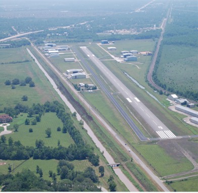
| Facility Name: | HOUSTON/SOUTHWEST |
| City Name: | HOUSTON |
| County: | FORT BEND |
| State abbrev: | TX |
| State Name: | TEXAS |
| | |
| Ownership: | PRIVATELY OWNED |
| Use: | OPEN TO THE PUBLIC |
| Owner's Name: | JAMES GRIFFITH JR |
| Address: | 503 MC KEEVER RD |
| | ARCOLA, TX 77583 |
| Owner's Phone: | 281-431-2581 |
| | |
| Manager's Name: | LEN FRANKLIN |
| Address: | 503 MC KEEVER RD #1505 |
| | ARCOLA, TX 77583 |
| Phone: | 281-431-2581 |
| | |
| FAA Region: | SOUTHWEST |
| FAA Field Office: | TEX |
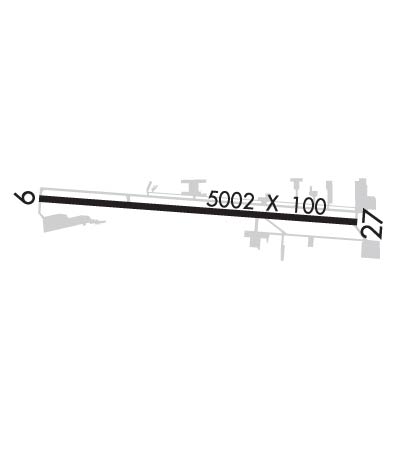
Runway Identifications
Runway Identification: 09/27Length: 5002 ft
Width: 100 ft
Surface: ASPHALT
Edge lights: Medium IntensityTreatment: NONE
| | Runway: 09 | | Runway: 27 |
| Mag heading: | 89° | Mag heading: | 269° |
| Rwy Slope: | -.05% Down | Rwy Slope: | .05% Up |
| Approach: | LOC/DME | Approach: | |
| Pattern: | Left Traffic | Pattern: | Left Traffic |
| Markings: | NONPRECISION INSTRUMENT | Markings: | NONPRECISION INSTRUMENT |
| Marking Condition: | GOOD | Marking Condition: | GOOD |
| Arresting Dev: | | Arresting Dev: | |
| Lat & Long: | N2930.4 W09529.1 | Lat. & Long.: | N2930.3 W09528.1 |
| Elev: | 68.9 ft. MSL | Elev: | 66.4 ft. MSL |
| TCH: | 50 ft. AGL | TCH: | 43 ft. AGL |
| Visual Glide Path: | 3.50 degrees | Visual Glide Path: | 3.00 degrees |
| Displaced Threshold: | No | Displaced Threshold: | No |
| Touchdown Zone: | YES | Touchdown Zone: | YES |
| Touchdown Elev.: | 68.9 feet | Touchdown Elev.: | 67.5 feet |
| Visual Glide Slope: | 2-Light PAPI on LEFT side of Runway | Visual Glide Slope: | 2-Light PAPI on LEFT side of Runway |
| RVR Equipment: | | RVR Equipment: | |
| RVV Equipment: | NO | RVV Equipment: | NO |
| Approach Lights: | | Approach Lights: | |
| REIL: | YES | REIL: | YES |
| Centerline Lights: | NO | Centerline Lights: | NO |
| Touchdown lights: | NO | Touchdown lights: | NO |
| Runway Category: | Runway with a Non-precision Approach having visibility minimums greater than 3/4 mile | Runway Category: | Runway with a Non-precision Approach having visibility minimums greater than 3/4 mile |
| Declared Distances: | | Declared Distances: | |
| Obstructions: | ROAD | Obstructions: | ROAD |
| Marked: | NOT Marked/Lighted | Marked: | NOT Marked/Lighted |
| Clearance slope: | 4:1 | Clearance slope: | 8:1 |
| Obstruction height: | 15 feet AGL | Obstruction height: | 15 feet AGL |
| Dist. from runway: | 265 feet | Dist. from runway: | 330 feet |
| Centerline offset: | 260 left of centerline | Centerline offset: | |
| Comments: | | Comments: | |