Current Weather/Notams (Metars, TAFs, Notams, NWS Forecast, PIREPS, and nearby weather)
Customs Information Send updates to Support@FltPlan.com
Customs Not Available
Database effective 04/18/2024
Airport Diagram might not be current.
|
| Facility Name: | ALGONA MUNI |
| City Name: | ALGONA |
| County: | KOSSUTH |
| State abbrev: | IA |
| State Name: | IOWA |
| | |
| Ownership: | PUBLICLY OWNED |
| Use: | OPEN TO THE PUBLIC |
| Owner's Name: | CITY OF ALGONA |
| Address: | 112 WEST CALL |
| | ALGONA, IA 50511 |
| Owner's Phone: | 515-295-2411 |
| | |
| Manager's Name: | JIM KOHLHAAS |
| Address: | 2907 HWY 18 W |
| | ALGONA, IA 50511 |
| Phone: | 515-295-7492 |
| | |
| FAA Region: | CENTRAL |
| FAA Field Office: | NONE |
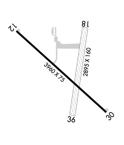
Runway Identifications
Runway Identification: 12/30Length: 3960 ft
Width: 75 ft
Surface: CONCRETE-GOOD CONDITION
Edge lights: Medium IntensityTreatment: NONE
Weight: PCN 7 /R/D/W/U
| | Runway: 12 | | Runway: 30 |
| Mag heading: | 129° | Mag heading: | 309° |
| Rwy Slope: | -.27% Down | Rwy Slope: | .27% Up |
| Approach: | | Approach: | |
| Pattern: | Left Traffic | Pattern: | Left Traffic |
| Markings: | NONPRECISION INSTRUMENT | Markings: | NONPRECISION INSTRUMENT |
| Marking Condition: | FAIR | Marking Condition: | FAIR |
| Arresting Dev: | | Arresting Dev: | |
| Lat & Long: | N4304.9 W09416.7 | Lat. & Long.: | N4304.5 W09416.0 |
| Elev: | 1214.7 ft. MSL | Elev: | 1204.1 ft. MSL |
| TCH: | 40 ft. AGL | TCH: | 40 ft. AGL |
| Visual Glide Path: | 3.00 degrees | Visual Glide Path: | 3.00 degrees |
| Displaced Threshold: | No | Displaced Threshold: | No |
| Touchdown Zone: | YES | Touchdown Zone: | YES |
| Touchdown Elev.: | 1214.7 feet | Touchdown Elev.: | 1213.2 feet |
| Visual Glide Slope: | 2-Light PAPI on LEFT side of Runway | Visual Glide Slope: | 2-Light PAPI on LEFT side of Runway |
| RVR Equipment: | | RVR Equipment: | |
| RVV Equipment: | NO | RVV Equipment: | NO |
| Approach Lights: | | Approach Lights: | |
| REIL: | YES | REIL: | YES |
| Centerline Lights: | NO | Centerline Lights: | NO |
| Touchdown lights: | NO | Touchdown lights: | NO |
| Runway Category: | Runway with a Non-precision Approach having visibility minimums greater than 3/4 mile | Runway Category: | Runway with a Non-precision Approach having visibility minimums greater than 3/4 mile |
| Declared Distances: | | Declared Distances: | |
| Obstructions: | ROAD | Obstructions: | TREES |
| Marked: | NOT Marked/Lighted | Marked: | NOT Marked/Lighted |
| Clearance slope: | 13:1 | Clearance slope: | 10:1 |
| Obstruction height: | 22 feet AGL | Obstruction height: | 58 feet AGL |
| Dist. from runway: | 500 feet | Dist. from runway: | 836 feet |
| Centerline offset: | 285 left of centerline | Centerline offset: | 379 feet right of centerline |
| Comments: | | Comments: | |
Runway Identification: 18/36Length: 2895 ft
Width: 160 ft
Surface: GRASS-FAIR CONDITION
Edge lights: Treatment: NONE
| | Runway: 18 | | Runway: 36 |
| Mag heading: | 186° | Mag heading: | 6° |
| Rwy Slope: | -.35% Down | Rwy Slope: | .35% Up |
| Approach: | | Approach: | |
| Pattern: | Left Traffic | Pattern: | Left Traffic |
| Markings: | NONSTANDARD | Markings: | NONSTANDARD |
| Marking Condition: | RY 18/36 MKD WITH YELLOW CONES. | Marking Condition: | |
| Arresting Dev: | | Arresting Dev: | |
| Lat & Long: | N4304.9 W09416.2 | Lat. & Long.: | N4304.4 W09416.3 |
| Elev: | 1214.4 ft. MSL | Elev: | 1204.2 ft. MSL |
| TCH: | | TCH: | |
| Visual Glide Path: | | Visual Glide Path: | |
| Displaced Threshold: | No | Displaced Threshold: | No |
| Touchdown Zone: | YES | Touchdown Zone: | YES |
| Touchdown Elev.: | 1214.4 feet | Touchdown Elev.: | 1214.4 feet |
| Visual Glide Slope: | | Visual Glide Slope: | |
| RVR Equipment: | | RVR Equipment: | |
| RVV Equipment: | NO | RVV Equipment: | NO |
| Approach Lights: | | Approach Lights: | |
| REIL: | NO | REIL: | NO |
| Centerline Lights: | NO | Centerline Lights: | NO |
| Touchdown lights: | NO | Touchdown lights: | NO |
| Runway Category: | Runway with a Visual Approach | Runway Category: | Runway with a Visual Approach |
| Declared Distances: | | Declared Distances: | |
| Obstructions: | ROAD | Obstructions: | FENCE |
| Marked: | NOT Marked/Lighted | Marked: | NOT Marked/Lighted |
| Clearance slope: | 22:1 | Clearance slope: | 33:1 |
| Obstruction height: | 15 feet AGL | Obstruction height: | 4 feet AGL |
| Dist. from runway: | 340 feet | Dist. from runway: | 135 feet |
| Centerline offset: | | Centerline offset: | |
| Comments: | | Comments: | 4' FENCE 135' FROM RWY END |