Current Weather/Notams (Metars, TAFs, Notams, NWS Forecast, PIREPS, and nearby weather)
Customs Information Send updates to Support@FltPlan.com
Customs Not Available
Database effective 04/18/2024
Airport Diagram might not be current.
|
| Facility Name: | ARLINGTON MUNI |
| City Name: | ARLINGTON |
| County: | SNOHOMISH |
| State abbrev: | WA |
| State Name: | WASHINGTON |
| | |
| Ownership: | PUBLICLY OWNED |
| Use: | OPEN TO THE PUBLIC |
| Owner's Name: | CITY OF ARLINGTON |
| Address: | CITY HALL, 238 N OLYMPIC |
| | ARLINGTON, WA 98223 |
| Owner's Phone: | 360-403-3470 |
| | |
| Manager's Name: | DAVID RYAN |
| Address: | 18204 59TH AVE NE, STE A |
| | ARLINGTON, WA 98223 |
| Phone: | 360-403-3474 |
| | |
| FAA Region: | NORTHWEST MOUNTAIN |
| FAA Field Office: | SEA |
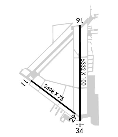
Runway Identifications
Runway Identification: 11/29Length: 3498 ft
Width: 75 ft
Surface: ASPHALT
Edge lights: Treatment: NONE
| | Runway: 11 | | Runway: 29 |
| Mag heading: | 110° | Mag heading: | 290° |
| Rwy Slope: | -.12% Down | Rwy Slope: | .12% Up |
| Approach: | | Approach: | |
| Pattern: | Right Traffic | Pattern: | Left Traffic |
| Markings: | BASIC | Markings: | BASIC |
| Marking Condition: | GOOD | Marking Condition: | GOOD |
| Arresting Dev: | | Arresting Dev: | |
| Lat & Long: | N4809.7 W12210.1 | Lat. & Long.: | N4809.4 W12209.4 |
| Elev: | 132.4 ft. MSL | Elev: | 128.2 ft. MSL |
| TCH: | 42 ft. AGL | TCH: | 40 ft. AGL |
| Visual Glide Path: | 3.50 degrees | Visual Glide Path: | 4.00 degrees |
| Displaced Threshold: | No | Displaced Threshold: | No |
| Touchdown Zone: | YES | Touchdown Zone: | YES |
| Touchdown Elev.: | 132.6 feet | Touchdown Elev.: | 130.7 feet |
| Visual Glide Slope: | 2-Light PAPI on LEFT side of Runway | Visual Glide Slope: | 2-Light PAPI on LEFT side of Runway |
| RVR Equipment: | | RVR Equipment: | |
| RVV Equipment: | NO | RVV Equipment: | NO |
| Approach Lights: | | Approach Lights: | |
| REIL: | YES | REIL: | YES |
| Centerline Lights: | NO | Centerline Lights: | NO |
| Touchdown lights: | NO | Touchdown lights: | NO |
| Runway Category: | Runway with a Visual Approach | Runway Category: | Runway with a Visual Approach |
| Declared Distances: | | Declared Distances: | |
| Obstructions: | | Obstructions: | TREE |
| Marked: | | Marked: | NOT Marked/Lighted |
| Clearance slope: | 50:1 | Clearance slope: | 21:1 |
| Obstruction height: | | Obstruction height: | 176 feet AGL |
| Dist. from runway: | | Dist. from runway: | 3967 feet |
| Centerline offset: | | Centerline offset: | 465 feet right of centerline |
| Comments: | | Comments: | |
Runway Identification: 16/34Length: 5332 ft
Width: 100 ft
Surface: ASPHALT
Edge lights: Medium IntensityTreatment: NONE
| | Runway: 16 | | Runway: 34 |
| Mag heading: | 162° | Mag heading: | 342° |
| Rwy Slope: | -.25% Down | Rwy Slope: | .25% Up |
| Approach: | | Approach: | LOCALIZER |
| Pattern: | Right Traffic | Pattern: | Left Traffic |
| Markings: | NONPRECISION INSTRUMENT | Markings: | NONPRECISION INSTRUMENT |
| Marking Condition: | GOOD | Marking Condition: | GOOD |
| Arresting Dev: | | Arresting Dev: | |
| Lat & Long: | N4810.2 W12209.4 | Lat. & Long.: | N4809.3 W12209.4 |
| Elev: | 140.9 ft. MSL | Elev: | 127.5 ft. MSL |
| TCH: | 40 ft. AGL | TCH: | 36 ft. AGL |
| Visual Glide Path: | 3.00 degrees | Visual Glide Path: | 3.00 degrees |
| Displaced Threshold: | No | Displaced Threshold: | No |
| Touchdown Zone: | YES | Touchdown Zone: | YES |
| Touchdown Elev.: | 141.8 feet | Touchdown Elev.: | 135.4 feet |
| Visual Glide Slope: | 2-Light PAPI on LEFT side of Runway | Visual Glide Slope: | 2-Light PAPI on LEFT side of Runway |
| RVR Equipment: | | RVR Equipment: | |
| RVV Equipment: | NO | RVV Equipment: | NO |
| Approach Lights: | | Approach Lights: | MALS - 1,400 foot medium intensity approach lighting system |
| REIL: | YES | REIL: | NO |
| Centerline Lights: | NO | Centerline Lights: | NO |
| Touchdown lights: | NO | Touchdown lights: | NO |
| Runway Category: | Runway with a Visual Approach | Runway Category: | Runway with a Non-precision Approach having visibility minimums greater than 3/4 mile |
| Declared Distances: | | Declared Distances: | |
| Obstructions: | TREE | Obstructions: | |
| Marked: | NOT Marked/Lighted | Marked: | |
| Clearance slope: | 22:1 | Clearance slope: | 50:1 |
| Obstruction height: | 92 feet AGL | Obstruction height: | |
| Dist. from runway: | 2287 feet | Dist. from runway: | |
| Centerline offset: | 200 left of centerline | Centerline offset: | |
| Comments: | | Comments: | |

