
| ||||||||||||||||||||||||||||||||
| ||||||||||||||||||||||||||||||||
| ||||||||||||||||||||||||||||||||
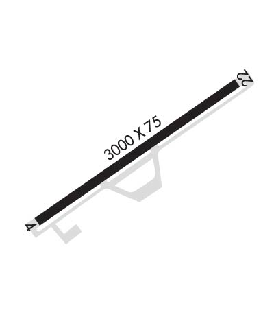
| Rwy | Rwy | |||||||
| 3000x75 | 3000' | 3000x75 | 3000' | |||||
| Runway ID | Single Wheel | Double Wheel | Double Tandem Wheel | Dual Double Wheel |
| 04/22 | N/A | N/A | N/A | N/A |
| These numbers are Advisory and are not limits. The Airport Manager should have more accurate Weight Limits | ||||
 Airport Diagram might not be current. | |
| Facility Name: | CATALINA |
| City Name: | AVALON |
| County: | LOS ANGELES |
| State abbrev: | CA |
| State Name: | CALIFORNIA |
| Ownership: | PRIVATELY OWNED |
| Use: | OPEN TO THE PUBLIC |
| Owner's Name: | SANTA CATALINA IS CONSERVANCY; CATALINA ISLAND CONSERVANCY, ARPT MGR CARL TRUE 714-732-2607; ASST MGR EFRAIH CALDERA 562-889-0481. |
| Address: | BOX 2739 |
| AVALON, CA 90704 | |
| Owner's Phone: | 310-510-0143 |
| Manager's Name: | CARL TRUE |
| Address: | P.O. BOX 1927 |
| AVALON, CA 90704 | |
| Phone: | 310-510-0143 |
| FAA Region: | WESTERN-PACIFIC |
| FAA Field Office: | LAX |
| Date | Sunrise | Sunset |
|---|---|---|
| 04/22/24 Monday | 6:14 | 19:30 |
| 04/23/24 Tuesday | 6:13 | 19:31 |
| 04/24/24 Wednesday | 6:12 | 19:32 |
| 04/25/24 Thursday | 6:11 | 19:33 |
| 04/26/24 Friday | 6:10 | 19:33 |
| 04/27/24 Saturday | 6:09 | 19:34 |
| 04/28/24 Sunday | 6:08 | 19:35 |
| 04/29/24 Monday | 6:07 | 19:36 |
| 04/30/24 Tuesday | 6:06 | 19:36 |
| 05/01/24 Wednesday | 6:05 | 19:37 |
| 05/02/24 Thursday | 6:04 | 19:38 |
| 05/03/24 Friday | 6:03 | 19:39 |
| 05/04/24 Saturday | 6:02 | 19:39 |
| 05/05/24 Sunday | 6:01 | 19:40 |
| Airport Attendance Schedule | 7 Days A Week 0800-1700; CLSD THANKSGIVING AND CHRISTMAS TO ALL TNST TFC. |
| Airport Status | OPERATIONAL (This Status can change at any time - please check NOTAMS) |
| Airport Lighting Schedule | ACTVT REIL RWY 22 - CTAF. PSIL RWY 22 OPR DRG ARPT OPERG HRS. |
| Airport Storage Available | Tie Downs |
| Extra Services Available | NONE |
| Wind Indicator | YES - (lighted) |
| Control Tower | NO |
| CTAF Frequency | 122.700 |
| Unicom Frequency | 122.700 |
| Rotating Beacon Color | |
| Segmented Circle | YES |
| Landing Fee | YES |
| Airport Inspected | STATE - performed by STATE AERONAUTICAL PERSONNEL |
| Inspection Date | 07/13/2022 |
| Type of Fuel Available | None |
| Airframe Repair Service | NONE |
| Power Plant Repair Service | NONE |
| Latitude | N3324.3 |
| Longitude | W11824.9 (ESTIMATED) |
| Arpt Elevation | 1602ft (ESTIMATED) |
| Magnetic Variation | 14E |
| 6 miles NW | of AVALON |
| Traffic Pattern Altitude | |
| Sectional Chart | LOS ANGELES |
| Operations (Reported) | Yearly | Avg. Daily |
|---|---|---|
| General Aviation Transient | 10200 | 28 |
| General Aviation Local | 1025 | 3 |
| Air Taxi | 2266 | 6 |
| Commerical | 0 | 0 |
| Commuter | 0 | 0 |
| Military | 25 | 0 |
| Aircraft based on Field | |
|---|---|
| General Aviation Singles | 6 |
| General Aviation Multi | 0 |
| Jet Aircraft | 0 |
| General Aviation Helicopters | 0 |
| Military Aircraft | 0 |
| Gliders | 0 |
| Ultralights | 0 |
| FSS on field | NO |
| FSS tie-in | HAWTHORNE |
| FSS Phone | 1-800-WX-BRIEF |
| Who issues Notams | AVX |
| Notam D service at airport | YES |
| ARTCC Name | LOS ANGELES |
| Airport Certification | |
| Aircraft Rescue & Firefighting Index | None |
| Airport of Entry | No |
| Custom Landing Rights | No |
| Joint Civil/Military | No |
| Military Landing rights | No |
| FULL STOP LDG ONLY; INTXN TKOFS PROHIBITED. |
| LANDING FEE. |
| RWY 4-22 NON-STD RWY SAFETY AREAS. |
| FOR CD CTC SOCAL APCH AT 800-448-3724. |
| NO JET ACFT OPS AUTH. |
| OPS PROHIBITED AT NIGHT OR WHEN ARPT IS UNATNDD. |
| PILOTS CANNOT SEE ACFT ON OPPOSITE ENDS OF RWY DUE TO GRADIENT, MUST ANNC TAKING ACTIVE RWY ON UNICOM PRIOR TO DEP. |
| RWY 04/22 LTD BY ARPT OPR TO 12500 LBS MTOW. |
| RWY 04 FINAL 2300 FT STEEP 2.1% DOWNSLOPE; RWY 22 UPSLOPE PREFERRED LDG. |
| RWY 04/2 2 OTS INDEFLY. |
Airport Communications & Frequencies:
| ||||||||||||||
| Runway: 04 | Runway: 22 | ||
| Mag heading: | 41° | Mag heading: | 221° |
| Rwy Slope: | -1.77% Down | Rwy Slope: | 1.77% Up |
| Approach: | Approach: | ||
| Pattern: | Left Traffic | Pattern: | Right Traffic |
| Markings: | BASIC | Markings: | BASIC |
| Marking Condition: | GOOD | Marking Condition: | GOOD |
| Arresting Dev: | Arresting Dev: | ||
| Lat & Long: | N3324.2 W11825.2 | Lat. & Long.: | N3324.4 W11824.7 |
| Elev: | 1601.0 ft. MSL | Elev: | 1547.8 ft. MSL |
| TCH: | TCH: | 39 ft. AGL | |
| Visual Glide Path: | Visual Glide Path: | 3.00 degrees | |
| Displaced Threshold: | No | Displaced Threshold: | No |
| Touchdown Zone: | YES | Touchdown Zone: | YES |
| Touchdown Elev.: | 1602.0 feet | Touchdown Elev.: | 1602.0 feet |
| Visual Glide Slope: | Visual Glide Slope: | PULSATING/STEADY BURNING VASI ON LEFT SIDE OF RUNWAY | |
| RVR Equipment: | RVR Equipment: | ||
| RVV Equipment: | NO | RVV Equipment: | NO |
| Approach Lights: | Approach Lights: | ||
| REIL: | NO | REIL: | YES |
| Centerline Lights: | NO | Centerline Lights: | NO |
| Touchdown lights: | NO | Touchdown lights: | NO |
| Runway Category: | Runway with a Visual Approach | Runway Category: | Runway with a Visual Approach |
| Declared Distances: | Declared Distances: |
