Current Weather/Notams (Metars, TAFs, Notams, NWS Forecast, PIREPS, and nearby weather)
Customs Information Send updates to Support@FltPlan.com
Customs Not Available
Database effective 05/16/2024
Airport Diagram might not be current.
|
| Facility Name: | MARANA RGNL |
| City Name: | MARANA |
| County: | PIMA |
| State abbrev: | AZ |
| State Name: | ARIZONA |
| | |
| Ownership: | PUBLICLY OWNED |
| Use: | OPEN TO THE PUBLIC |
| Owner's Name: | TOWN OF MARANA |
| Address: | 11555 W. CIVIC CENTER DRIVE |
| | MARANA, AZ 85653 |
| Owner's Phone: | 520-382-1999 |
| | |
| Manager's Name: | GALEN BEEM |
| Address: | 11700 W. AVRA VALLEY RD, #91, TOWN OF MARANA |
| | MARANA, AZ 85653 |
| Phone: | 520-382-8053; 520-382-2607 |
| | |
| FAA Region: | WESTERN-PACIFIC |
| FAA Field Office: | PHX |
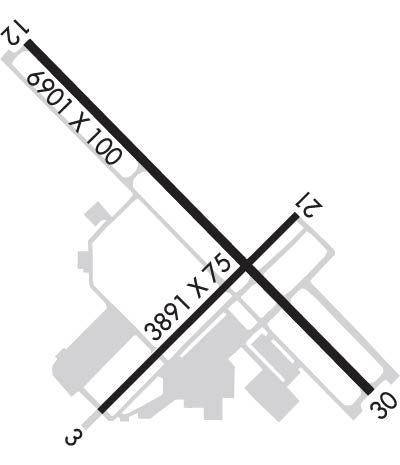
Runway Identifications
Runway Identification: 03/21Length: 3892 ft
Width: 75 ft
Surface: ASPHALT-GOOD CONDITION
Edge lights: Medium IntensityTreatment: NONE
| | Runway: 03 | | Runway: 21 |
| Mag heading: | 33° | Mag heading: | 213° |
| Rwy Slope: | .14% Up | Rwy Slope: | -.14% Down |
| Approach: | | Approach: | |
| Pattern: | Right Traffic | Pattern: | Left Traffic |
| Markings: | BASIC | Markings: | BASIC |
| Marking Condition: | GOOD | Marking Condition: | GOOD |
| Arresting Dev: | | Arresting Dev: | |
| Lat & Long: | N3224.2 W11113.4 | Lat. & Long.: | N3224.7 W11112.8 |
| Elev: | 2019.0 ft. MSL | Elev: | 2024.6 ft. MSL |
| TCH: | 53 ft. AGL | TCH: | 41 ft. AGL |
| Visual Glide Path: | 2.91 degrees | Visual Glide Path: | 2.91 degrees |
| Displaced Threshold: | 494 feet | Displaced Threshold: | No |
| Touchdown Zone: | YES | Touchdown Zone: | YES |
| Touchdown Elev.: | 2025.9 feet | Touchdown Elev.: | 2025.9 feet |
| Visual Glide Slope: | 2-Light PAPI on LEFT side of Runway | Visual Glide Slope: | 2-Light PAPI on LEFT side of Runway; PAPI UNUSBL BYD 7.0 NM DUE TO TRRN. |
| RVR Equipment: | | RVR Equipment: | |
| RVV Equipment: | NO | RVV Equipment: | NO |
| Approach Lights: | | Approach Lights: | |
| REIL: | YES | REIL: | YES |
| Centerline Lights: | NO | Centerline Lights: | NO |
| Touchdown lights: | NO | Touchdown lights: | NO |
| Runway Category: | Runway with a Non-precision Approach | Runway Category: | Runway with a Non-precision Approach |
| Declared Distances: | | Declared Distances: | |
| Obstructions: | ROAD | Obstructions: | BRUSH |
| Marked: | NOT Marked/Lighted | Marked: | NOT Marked/Lighted |
| Clearance slope: | APCH RATIO 50:1 TO DTHR. | Clearance slope: | 1:1 |
| Obstruction height: | 15 feet AGL | Obstruction height: | 13 feet AGL |
| Dist. from runway: | 200 feet | Dist. from runway: | 225 feet |
| Centerline offset: | 250 right of centerline | Centerline offset: | 150 feet right of centerline |
| Comments: | | Comments: | |
Runway Identification: 12/30Length: 6901 ft
Width: 100 ft
Surface: ASPHALT-GOOD CONDITION
Edge lights: Medium IntensityTreatment: NONE
| | Runway: 12 | | Runway: 30 |
| Mag heading: | 123° | Mag heading: | 303° |
| Rwy Slope: | .30% Up | Rwy Slope: | -.30% Down |
| Approach: | | Approach: | |
| Pattern: | Left Traffic | Pattern: | Right Traffic |
| Markings: | NONPRECISION INSTRUMENT | Markings: | NONPRECISION INSTRUMENT |
| Marking Condition: | GOOD | Marking Condition: | GOOD |
| Arresting Dev: | | Arresting Dev: | |
| Lat & Long: | N3225.1 W11113.6 | Lat. & Long.: | N3224.2 W11112.6 |
| Elev: | 2010.6 ft. MSL | Elev: | 2031.4 ft. MSL |
| TCH: | 45 ft. AGL | TCH: | 45 ft. AGL |
| Visual Glide Path: | 3.06 degrees | Visual Glide Path: | 3.41 degrees |
| Displaced Threshold: | No | Displaced Threshold: | No |
| Touchdown Zone: | YES | Touchdown Zone: | YES |
| Touchdown Elev.: | 2022.0 feet | Touchdown Elev.: | 2031.5 feet |
| Visual Glide Slope: | 4-Light PAPI on LEFT side of Runway | Visual Glide Slope: | 4-Light PAPI on LEFT side of Runway; PAPI UNUSBL BYD 3.5 NM DUE TO TRRN. |
| RVR Equipment: | | RVR Equipment: | |
| RVV Equipment: | NO | RVV Equipment: | NO |
| Approach Lights: | | Approach Lights: | |
| REIL: | YES | REIL: | YES |
| Centerline Lights: | NO | Centerline Lights: | NO |
| Touchdown lights: | NO | Touchdown lights: | NO |
| Runway Category: | Runway with a Non-precision Approach having visibility minimums greater than 3/4 mile | Runway Category: | Runway with a Visual Approach |
| Declared Distances: | | Declared Distances: | |

