Current Weather/Notams (Metars, TAFs, Notams, NWS Forecast, PIREPS, and nearby weather)
Customs Information Send updates to Support@FltPlan.com
Customs Not Available
Database effective 04/18/2024
Airport Diagram might not be current. Facility Name: ALVA RGNL City Name: ALVA County: WOODS State abbrev: OK State Name: OKLAHOMA Ownership: PUBLICLY OWNED Use: OPEN TO THE PUBLIC Owner's Name: CITY OF ALVA Address: 415 4TH ST. ALVA, OK 73717 Owner's Phone: 580-327-1340 Manager's Name: DERRICK COURSON Address: 2875 COLLEGE BLVD. ALVA, OK 73717 Phone: 580-327-2898 FAA Region: SOUTHWEST FAA Field Office: AOK
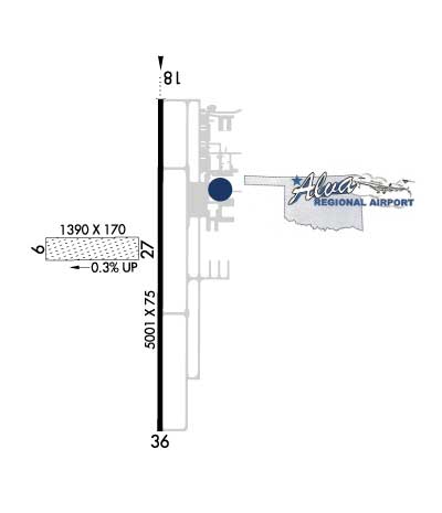
Runway Identifications Help
Runway Identification: 09/27 Length: 1390 ftWidth: 170 ftSurface: GRASS-GOOD CONDITIONEdge lights: Treatment: NONE Runway: 09 Runway: 27 Mag heading: 86° Mag heading: 266° Rwy Slope: -.29% Down Rwy Slope: .29% Up Approach: Approach: Pattern: Left Traffic Pattern: Left Traffic Markings: Markings: Marking Condition: Marking Condition: Arresting Dev: Arresting Dev: Lat & Long: N3646.4 W09840.6 Lat. & Long.: N3646.4 W09840.3 Elev: 1476.0 ft. MSL Elev: 1472.0 ft. MSL TCH: TCH: Visual Glide Path: Visual Glide Path: Displaced Threshold: No Displaced Threshold: No Touchdown Zone: NO Touchdown Zone: NO Touchdown Elev.: Touchdown Elev.: Visual Glide Slope: Visual Glide Slope: RVR Equipment: RVR Equipment: RVV Equipment: NO RVV Equipment: NO Approach Lights: Approach Lights: REIL: NO REIL: NO Centerline Lights: NO Centerline Lights: NO Touchdown lights: NO Touchdown lights: NO Runway Category: Runway with a Visual Approach Runway Category: Runway with a Visual Approach Declared Distances: Declared Distances:
Runway Identification: 18/36 Length: 5001 ftWidth: 75 ftSurface: CONCRETE-GOOD CONDITIONEdge lights: Medium Intensity Treatment: NONE Runway: 18 Runway: 36 Mag heading: 176° Mag heading: 356° Rwy Slope: -.16% Down Rwy Slope: .16% Up Approach: Approach: Pattern: Left Traffic Pattern: Left Traffic Markings: NONPRECISION INSTRUMENT Markings: NONPRECISION INSTRUMENT Marking Condition: GOOD Marking Condition: GOOD Arresting Dev: Arresting Dev: Lat & Long: N3646.8 W09840.2 Lat. & Long.: N3646.0 W09840.2 Elev: 1476.6 ft. MSL Elev: 1468.8 ft. MSL TCH: 47 ft. AGL TCH: 40 ft. AGL Visual Glide Path: 3.00 degrees Visual Glide Path: 3.00 degrees Displaced Threshold: No Displaced Threshold: No Touchdown Zone: YES Touchdown Zone: YES Touchdown Elev.: 1476.6 feet Touchdown Elev.: 1470.7 feet Visual Glide Slope: 4-Light PAPI on LEFT side of Runway Visual Glide Slope: 4-Light PAPI on LEFT side of Runway RVR Equipment: RVR Equipment: RVV Equipment: NO RVV Equipment: NO Approach Lights: ODALS - omnidirectional approach lighting system Approach Lights: REIL: NO REIL: YES Centerline Lights: NO Centerline Lights: NO Touchdown lights: NO Touchdown lights: NO Runway Category: Runway with a Non-precision Approach having visibility minimums greater than 3/4 mile Runway Category: Runway with a Non-precision Approach having visibility minimums greater than 3/4 mile Declared Distances: Declared Distances: