Current Weather/Notams (Metars, TAFs, Notams, NWS Forecast, PIREPS, and nearby weather)
Customs Information Send updates to Support@FltPlan.com
Customs Not Available
Database effective 04/18/2024
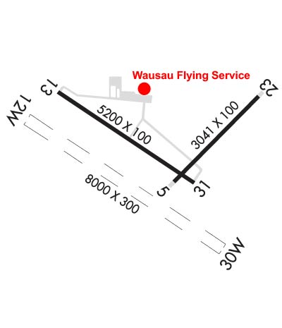
Airport Diagram might not be current. Facility Name: WAUSAU DOWNTOWN City Name: WAUSAU County: MARATHON State abbrev: WI State Name: WISCONSIN Ownership: PUBLICLY OWNED Use: OPEN TO THE PUBLIC Owner's Name: CITY OF WAUSAU Address: 407 GRANT ST. WAUSAU, WI 54403 Owner's Phone: 715-261-6740 Manager's Name: JOHN P CHMIEL Address: 725 WOODS PLACE WAUSAU, WI 54401 Phone: 715-845-3400 FAA Region: GREAT LAKES FAA Field Office: CHI
Runway Identifications Help
Runway Identification: 05/23 Length: 3041 ftWidth: 100 ftSurface: ASPHALT-FAIR CONDITIONEdge lights: Medium Intensity Treatment: NONE Runway: 05 Runway: 23 Mag heading: 47° Mag heading: 227° Rwy Slope: .35% Up Rwy Slope: -.35% Down Approach: Approach: Pattern: Left Traffic Pattern: Left Traffic Markings: BASIC Markings: BASIC Marking Condition: FAIR Marking Condition: FAIR Arresting Dev: Arresting Dev: Lat & Long: N4455.4 W08937.5 Lat. & Long.: N4455.7 W08937.0 Elev: 1190.4 ft. MSL Elev: 1201.0 ft. MSL TCH: TCH: Visual Glide Path: Visual Glide Path: Displaced Threshold: No Displaced Threshold: No Touchdown Zone: YES Touchdown Zone: YES Touchdown Elev.: 1201.0 feet Touchdown Elev.: 1201.0 feet Visual Glide Slope: Visual Glide Slope: RVR Equipment: RVR Equipment: RVV Equipment: NO RVV Equipment: NO Approach Lights: Approach Lights: REIL: NO REIL: NO Centerline Lights: NO Centerline Lights: NO Touchdown lights: NO Touchdown lights: NO Runway Category: Runway with a Visual Approach Runway Category: Runway with a Visual Approach Declared Distances: Declared Distances: Obstructions: TREE Obstructions: TREES Marked: NOT Marked/Lighted Marked: NOT Marked/Lighted Clearance slope: 3:1 Clearance slope: 3:1 Obstruction height: 40 feet AGL Obstruction height: 20 feet AGL Dist. from runway: 325 feet Dist. from runway: 265 feet Centerline offset: 80 left of centerline Centerline offset: 100 feet right of centerline Comments: Comments:
Runway Identification: 12W/30W Length: 8000 ftWidth: 300 ftSurface: WATER-GOOD CONDITIONEdge lights: Treatment: NONE Runway: 12W Runway: 30W Mag heading: N/A Mag heading: N/A Rwy Slope: .00% Rwy Slope: .00% Approach: Approach: Pattern: Left Traffic Pattern: Left Traffic Markings: NONE Markings: NONE Marking Condition: GOOD Marking Condition: GOOD Arresting Dev: Arresting Dev: Lat & Long: N4455.8 W08938.7 Lat. & Long.: N4455.0 W08937.2 Elev: 1166.0 ft. MSL Elev: 1166.0 ft. MSL TCH: TCH: Visual Glide Path: Visual Glide Path: Displaced Threshold: No Displaced Threshold: No Touchdown Zone: YES Touchdown Zone: YES Touchdown Elev.: 1166.0 feet Touchdown Elev.: 1166.0 feet Visual Glide Slope: Visual Glide Slope: RVR Equipment: RVR Equipment: RVV Equipment: NO RVV Equipment: NO Approach Lights: Approach Lights: REIL: NO REIL: NO Centerline Lights: NO Centerline Lights: NO Touchdown lights: NO Touchdown lights: NO Runway Category: Runway Category: Declared Distances: Declared Distances:
Runway Identification: 13/31 Length: 5200 ftWidth: 100 ftSurface: ASPHALT-FAIR CONDITIONEdge lights: Medium Intensity Treatment: NONE Runway: 13 Runway: 31 Mag heading: 127° Mag heading: 307° Rwy Slope: -.04% Down Rwy Slope: .04% Up Approach: Approach: Pattern: Left Traffic Pattern: Left Traffic Markings: NONPRECISION INSTRUMENT Markings: NONPRECISION INSTRUMENT Marking Condition: FAIR Marking Condition: FAIR Arresting Dev: Arresting Dev: Lat & Long: N4455.8 W08938.4 Lat. & Long.: N4455.4 W08937.4 Elev: 1192.1 ft. MSL Elev: 1190.1 ft. MSL TCH: 43 ft. AGL TCH: 44 ft. AGL Visual Glide Path: 3.00 degrees Visual Glide Path: 3.00 degrees Displaced Threshold: No Displaced Threshold: No Touchdown Zone: YES Touchdown Zone: YES Touchdown Elev.: 1195.7 feet Touchdown Elev.: 1195.3 feet Visual Glide Slope: 4-Light PAPI on LEFT side of Runway Visual Glide Slope: 4-Light PAPI on LEFT side of Runway RVR Equipment: RVR Equipment: RVV Equipment: NO RVV Equipment: NO Approach Lights: Approach Lights: REIL: YES REIL: YES Centerline Lights: NO Centerline Lights: NO Touchdown lights: NO Touchdown lights: NO Runway Category: D Runway Category: Runway with a Non-precision Approach having visibility minimums greater than 3/4 mile Declared Distances: Declared Distances: Obstructions: TREES Obstructions: TREES Marked: NOT Marked/Lighted Marked: NOT Marked/Lighted Clearance slope: 1:1 Clearance slope: Obstruction height: 34 feet AGL Obstruction height: 38 feet AGL Dist. from runway: 250 feet Dist. from runway: 225 feet Centerline offset: 410 left of centerline Centerline offset: 375 feet left of centerline Comments: 30 FT TREES 0-200 FT FM THR 300 FT R & 450 FT L. Comments: 30 FT TREES 150 FT FM THR 425 FT L.