
| ||||||||||||||||||||||||||||||||||||||||||||
| ||||||||||||||||||||||||||||||||||||||||||||
| ||||||||||||||||||||||||||||||||||||||||||||
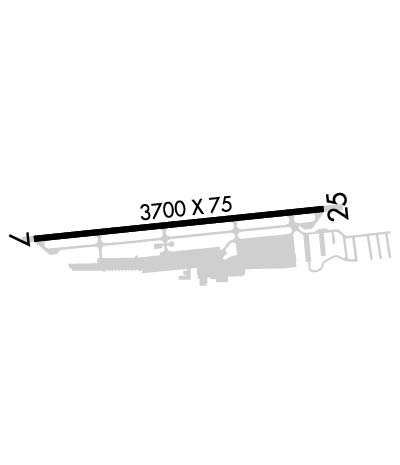
| Rwy | Rwy | |||||||
| 3700x75 | 3500' | 3700x75 | 3700' | |||||
| Runway ID | Single Wheel | Double Wheel | Double Tandem Wheel | Dual Double Wheel |
| 07/25 | 30,000 | N/A | N/A | N/A |
| These numbers are Advisory and are not limits. The Airport Manager should have more accurate Weight Limits | ||||
 Airport Diagram might not be current. | |
| Facility Name: | AUBURN MUNI |
| City Name: | AUBURN |
| County: | PLACER |
| State abbrev: | CA |
| State Name: | CALIFORNIA |
| Ownership: | PUBLICLY OWNED |
| Use: | OPEN TO THE PUBLIC |
| Owner's Name: | CITY OF AUBURN |
| Address: | 1225 LINCOLN WAY |
| AUBURN, CA 95603 | |
| Owner's Phone: | 530-823-4211 |
| Manager's Name: | TYGHE RICHARDSON |
| Address: | 1225 LINCOLN WAY |
| AUBURN, CA 95603 | |
| Phone: | 530-888-8174 |
| FAA Region: | WESTERN-PACIFIC |
| FAA Field Office: | SFO |

| Date | Sunrise | Sunset |
|---|---|---|
| 04/15/24 Monday | 6:27 | 19:42 |
| 04/16/24 Tuesday | 6:25 | 19:43 |
| 04/17/24 Wednesday | 6:24 | 19:44 |
| 04/18/24 Thursday | 6:22 | 19:45 |
| 04/19/24 Friday | 6:21 | 19:46 |
| 04/20/24 Saturday | 6:20 | 19:47 |
| 04/21/24 Sunday | 6:18 | 19:48 |
| 04/22/24 Monday | 6:17 | 19:49 |
| 04/23/24 Tuesday | 6:15 | 19:50 |
| 04/24/24 Wednesday | 6:14 | 19:51 |
| 04/25/24 Thursday | 6:13 | 19:52 |
| 04/26/24 Friday | 6:12 | 19:53 |
| 04/27/24 Saturday | 6:10 | 19:54 |
| 04/28/24 Sunday | 6:09 | 19:55 |
| Airport Attendance Schedule | 7 Days A Week 0800-1800 |
| Airport Status | OPERATIONAL (This Status can change at any time - please check NOTAMS) |
| Airport Lighting Schedule | ACTVT PAPI RWY 07; MIRL RWY 07/25 - CTAF. PAPI RWY 25 OPER CONTINUOUS |
| Airport Storage Available | Tie Downs, Hanger |
| Extra Services Available | Avionics, Charter, Flight Instruction, Aircraft Rental |
| Wind Indicator | YES - (lighted) |
| Control Tower | NO |
| CTAF Frequency | 122.700 |
| Unicom Frequency | 122.700 |
| Rotating Beacon Color | WG |
| Segmented Circle | YES |
| Landing Fee | NO |
| Airport Inspected | STATE - performed by STATE AERONAUTICAL PERSONNEL |
| Inspection Date | 12/21/2023 |
| Type of Fuel Available | Grade 100LL, JET A (freeze point -40C), JET A-1 (freeze point -50C) |
| Airframe Repair Service | MAJOR |
| Power Plant Repair Service | MAJOR |
| Latitude | N3857.3 |
| Longitude | W12104.9 (ESTIMATED) |
| Arpt Elevation | 1538ft (SURVEYED) |
| Magnetic Variation | 16E |
| 3 miles N | of AUBURN |
| Traffic Pattern Altitude | HEL TFC PAT 580 FT AGL. |
| Sectional Chart | SAN FRANCISCO |
| Operations (Reported) | Yearly | Avg. Daily |
|---|---|---|
| General Aviation Transient | 37012 | 101 |
| General Aviation Local | 36965 | 101 |
| Air Taxi | 1100 | 3 |
| Commerical | 0 | 0 |
| Commuter | 0 | 0 |
| Military | 0 | 0 |
| Aircraft based on Field | |
|---|---|
| General Aviation Singles | 206 |
| General Aviation Multi | 17 |
| Jet Aircraft | 3 |
| General Aviation Helicopters | 9 |
| Military Aircraft | 0 |
| Gliders | 1 |
| Ultralights | 0 |
| FSS on field | NO |
| FSS tie-in | RANCHO MURIETA |
| FSS Phone | 1-800-WX-BRIEF |
| Who issues Notams | AUN |
| Notam D service at airport | YES |
| ARTCC Name | OAKLAND |
| Airport Certification | |
| Aircraft Rescue & Firefighting Index | None |
| Airport of Entry | No |
| Custom Landing Rights | No |
| Joint Civil/Military | No |
| Military Landing rights | YES |
| NATIONAL PLAN OF INTEGRATED AIRPORT SYSTEMS (NPIAS) |
| GRANT AGREEMENTS UNDER FAAP/ADAP/AIP |
| ASSURANCES PURSUANT TO TITLE VI, CIVIL RIGHTS ACT OF 1964 |
| FUEL 100LL & JET A AVAILABLE 24 HRS |
| ULTRALIGHT ACTIVITY ON AND INVOF ARPT. |
| FOR CD CTC NORCAL APCH AT 916-361-6874. |
| NOISE ABATEMENT ALL DEPS MIN PWR WHILE OBSG SAFE ACFT OPS. |
| VFR NOISE ABATEMENT PROC FOR RWY 25 DEP AT END OF RWY TRACK 230 OVER SELF-STORAGE FAC TO AVOID NOISE SENSITIVE AREAS. TURN ON CRS AFTER RCHG 2500 MSL. |
Airport Communications & Frequencies:
| ||||||||||||||
| Runway: 07 | Runway: 25 | ||
| Mag heading: | 68° | Mag heading: | 248° |
| Rwy Slope: | 1.23% Up | Rwy Slope: | -1.23% Down |
| Approach: | Approach: | ||
| Pattern: | Left Traffic; HEL RIGHT TFC FOR RWY 07. | Pattern: | Left Traffic |
| Markings: | NONPRECISION INSTRUMENT | Markings: | NONPRECISION INSTRUMENT |
| Marking Condition: | GOOD | Marking Condition: | GOOD |
| Arresting Dev: | Arresting Dev: | ||
| Lat & Long: | N3857.3 W12105.3 | Lat. & Long.: | N3857.3 W12104.5 |
| Elev: | 1493.0 ft. MSL | Elev: | 1538.4 ft. MSL |
| TCH: | 21 ft. AGL | TCH: | 34 ft. AGL |
| Visual Glide Path: | 3.00 degrees | Visual Glide Path: | 3.50 degrees |
| Displaced Threshold: | 200 feet | Displaced Threshold: | No |
| Touchdown Zone: | YES | Touchdown Zone: | YES |
| Touchdown Elev.: | 1531.9 feet | Touchdown Elev.: | 1538.4 feet |
| Visual Glide Slope: | 2-Light PAPI on LEFT side of Runway | Visual Glide Slope: | 2-Light PAPI on LEFT side of Runway; PAPI UNUSBL BYD 5 DEG LEFT OF CNTRLN |
| RVR Equipment: | RVR Equipment: | ||
| RVV Equipment: | NO | RVV Equipment: | NO |
| Approach Lights: | Approach Lights: | ||
| REIL: | NO | REIL: | NO |
| Centerline Lights: | NO | Centerline Lights: | NO |
| Touchdown lights: | NO | Touchdown lights: | NO |
| Runway Category: | Runway with a Non-precision Approach | Runway Category: | Runway with a Visual Approach |
| Declared Distances: | Declared Distances: | ||
| Obstructions: | HILL | Obstructions: | HILL |
| Marked: | NOT Marked/Lighted | Marked: | NOT Marked/Lighted |
| Clearance slope: | 35:1 | Clearance slope: | 22:1 |
| Obstruction height: | 4 feet AGL | Obstruction height: | 10 feet AGL |
| Dist. from runway: | 342 feet | Dist. from runway: | 425 feet |
| Centerline offset: | Centerline offset: | 90 feet left of centerline | |
| Comments: | Comments: |