Click here for more info on on SMS!

KAUM

AUSTIN MUNI
AUSTIN
MN
Time Zone: Central
Lat: N 4339.8
Long: W 09256.0
Elev: 1234
Var: -00
Longest Runway: 5800
AWOS: 119.02
CTAF: 122.7

FBO & Flight Services info for KAUM

FBOs: Update your Fuel Prices

AUSTIN AEROFLIGHTPh: 507-433-1813 Fax: 507-433-5867 Freq: 122.7
AWOSPh: 507-433-6667
-
Freq: 119.02  
If you are an FBO, call 1-203-262-1700 to update your info or email: FltPlan.Advertising@garmin.com
Advertise your FBO on FltPlan.com

Runway & Approach Info for KAUM
Rwy
Length
Land Dist**
Approach*
  Rwy
Length
Land Dist**
Approach*
17
5800x100  5800'          
 
  
35
  5800x100  5800'          
LOC/GS
 110.55 - 351°  
 * only ILS, LOC, LDA, and SDF approaches to a specific runway are shown
** For any Declared Landing Distance Available, please see A/FD or Approach plates
Runway Weight Capability (lbs.) Help
Runway IDSingle WheelDouble WheelDouble Tandem WheelDual Double Wheel
17/35100,000135,000N/AN/A
These numbers are Advisory and are not limits.   The Airport Manager should have more accurate Weight Limits
Approach Charts
Approaches    
Current Weather/Notams
Customs Information Send updates to Support@FltPlan.com
Customs Not Available
Database effective 04/18/2024
Airport Diagram of KAUM
Airport Diagram might not be current.

Facility Name: AUSTIN MUNI
City Name: AUSTIN
County: MOWER
State abbrev: MN
State Name: MINNESOTA
   
Ownership: PUBLICLY OWNED
Use: OPEN TO THE PUBLIC
Owner's Name: CITY OF AUSTIN
Address: 500 4TH AV NE
 AUSTIN, MN 55912-3773
Owner's Phone: 507-437-7674
  
Manager's Name: BRUCE W BUDAHN
Address: 710 21ST ST NE
 AUSTIN, MN 55912-4165
Phone: 507-433-1813; 507-433-1813.
   
FAA Region: GREAT LAKES
FAA Field Office: DMA


Sunrise / Sunset times for AUSTIN MUNI

DateSunriseSunset
04/18/24 Thursday6:2320:00
04/19/24 Friday6:2120:01
04/20/24 Saturday6:2020:02
04/21/24 Sunday6:1820:03
04/22/24 Monday6:1620:05
04/23/24 Tuesday6:1520:06
04/24/24 Wednesday6:1320:07
04/25/24 Thursday6:1220:08
04/26/24 Friday6:1020:09
04/27/24 Saturday6:0920:10
04/28/24 Sunday6:0720:12
04/29/24 Monday6:0620:13
04/30/24 Tuesday6:0420:14
05/01/24 Wednesday6:0320:15

Airport Facilities

Airport Attendance ScheduleMON-FRI 0800-1700, SAT 0800-1600, SUN 0900-1500
Airport Status OPERATIONAL (This Status can change at any time - please check NOTAMS)
Airport Lighting ScheduleACTVT MALSR RWY 35; REIL RWY 17; PAPI RWY 17 & 35; HIRL RWY 17/35 DALGT - CTAF. HIRL RWY 17/35 PRESET LOW INTST AT NIGHT; TO INCR INTST - CTAF.
Airport Storage AvailableTie Downs, Hanger
Extra Services AvailableFlight Instruction, Aircraft Rental, Aircraft Sales
Wind IndicatorYES - (lighted)
Control TowerNO
CTAF Frequency122.700
Unicom Frequency122.700
Rotating Beacon ColorWG
Segmented CircleNO
Landing FeeNO

Airport Inspection Data

Airport InspectedSTATE - performed by STATE AERONAUTICAL PERSONNEL
Inspection Date06/07/2023

Airport Services

Type of Fuel AvailableGrade 100LL, JET A (freeze point -40C); -10AFT HRS CTC FBO 507-433-1813.
Airframe Repair ServiceMAJOR
Power Plant Repair ServiceMAJOR

Geographic Data

LatitudeN4339.8
LongitudeW09256.0 (ESTIMATED)
Arpt Elevation1233ft (SURVEYED)
Magnetic Variation00E
2 miles Eof AUSTIN
Traffic Pattern Altitude
Sectional ChartCHICAGO

Aircraft Data

Operations (Reported)YearlyAvg. Daily
General Aviation Transient 800022
General Aviation Local 1700047
Air Taxi 3001
Commerical 00
Commuter 00
Military 1200
Aircraft based on Field
General Aviation Singles 10
General Aviation Multi 0
Jet Aircraft 3
General Aviation Helicopters 0
Military Aircraft 0
Gliders 0
Ultralights 0

FAA Services

FSS on field NO
FSS tie-in PRINCETON
FSS Phone 1-800-WX-BRIEF
Who issues Notams AUM
Notam D service at airport YES
ARTCC Name MINNEAPOLIS

Federal Status

Airport Certification
Aircraft Rescue & Firefighting IndexNone
Airport of EntryNo
Custom Landing RightsNo
Joint Civil/MilitaryNo
Military Landing rightsYES

Federal Agreements

NATIONAL PLAN OF INTEGRATED AIRPORT SYSTEMS (NPIAS)
GRANT AGREEMENTS UNDER FAAP/ADAP/AIP
ASSURANCES PURSUANT TO TITLE VI, CIVIL RIGHTS ACT OF 1964

Remarks

MIGRATORY WATERFOWL & DEER INVOF ARPT.
FOR CD CTC ROCHESTER APCH AT 507-424-8111.
Airport Communications & Frequencies:
CTAF Frequency:
122.700
Unicom Frequency:
122.700
Remarks
  • APCH/DEP SVC PRVDD BY MINNEAPOLIS ARTCC ON FREQS 132.35/307.3 (ROCHESTER RCAG) WHEN ROCHESTER APCH CTL CLSD.
  • ROCHESTER Primary Approach Frequencies:  
    119.8
    251.125
    ROCHESTER Primary Departure Frequencies:  
    119.8
    251.125
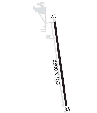
    Runway Identifications
    Runway Identification: 17/35
    Length: 5800 ft
    Width: 100 ft
    Surface: CONCRETE-GOOD CONDITION
    Edge lights: High Intensity

    Treatment: NONE
    Weight: PCN 48 /R/C/W/T

     Runway: 17   Runway: 35
    Mag heading: 172°Mag heading: 352°
    Rwy Slope: .00% DownRwy Slope: .00% Up
    Approach: Approach: LOC/GS
    Pattern: Left TrafficPattern: Left Traffic
    Markings: PRECISION INSTRUMENTMarkings: PRECISION INSTRUMENT
    Marking Condition: GOODMarking Condition: GOOD
    Arresting Dev: Arresting Dev:
    Lat & Long: N4340.2  W09256.1Lat. & Long.: N4339.3  W09255.9
    Elev: 1231.0 ft. MSLElev: 1230.8 ft. MSL
    TCH: 41 ft. AGLTCH: 42 ft. AGL
    Visual Glide Path: 3.00 degreesVisual Glide Path: 3.00 degrees
    Displaced Threshold: NoDisplaced Threshold: No
    Touchdown Zone: YESTouchdown Zone: YES
    Touchdown Elev.: 1233.5 feetTouchdown Elev.: 1230.9 feet
    Visual Glide Slope: 4-Light PAPI on LEFT side of RunwayVisual Glide Slope: 4-Light PAPI on LEFT side of Runway
    RVR Equipment: RVR Equipment:
    RVV Equipment: NORVV Equipment: NO
    Approach Lights: Approach Lights: MALSR - 1,400 foot medium intensity approach lighting system with runway alignment indicator lights
    REIL: YESREIL: NO
    Centerline Lights: NOCenterline Lights: NO
    Touchdown lights: NOTouchdown lights: NO
    Runway Category: Runway with a Non-precision Approach having visibility minimums greater than 3/4 mileRunway Category: Precision Instrument Runway
    Declared Distances: Declared Distances:
    Obstructions: TREESObstructions:
    Marked: NOT Marked/LightedMarked:
    Clearance slope: 18:1Clearance slope: 50:1
    Obstruction height: 80 feet AGLObstruction height:
    Dist. from runway: 1705 feetDist. from runway:
    Centerline offset: 607 right of centerlineCenterline offset:
    Comments: Comments:
    C:5/P: