Click here for more info on on SMS!

KAUH

AURORA MUNI - AL POTTER FIELD
AURORA
NE
Time Zone: Central
Lat: N 4053.6
Long: W 09759.7
Elev: 1803
Var: -06
Longest Runway: 4301
AWOS: 121.22
CTAF: 122.8

FBO & Flight Services info for KAUH

FBOs: Update your Fuel Prices

AURORA MUNIPh: 402-694-3633
-
Freq: 122.8
Service
Jet
100LL
SAF
MoGas
Full        Last Update: 05/04/2024 11:52

Self  5.25    
 Address: 1406 NORTH HIGHWAY 14   AURORA, NE 68818
AWOSPh: 402-694-5472
-
Freq: 121.22  
If you are an FBO, call 1-203-262-1700 to update your info or email: FltPlan.Advertising@garmin.com
Advertise your FBO on FltPlan.com

Runway & Approach Info for KAUH
Rwy
Length
Land Dist**
Approach*
  Rwy
Length
Land Dist**
Approach*
16
4301x75  4301'          
 
  
34
  4301x75  4301'          
 
 * only ILS, LOC, LDA, and SDF approaches to a specific runway are shown
** For any Declared Landing Distance Available, please see A/FD or Approach plates
Runway Weight Capability (lbs.) Help
Runway IDSingle WheelDouble WheelDouble Tandem WheelDual Double Wheel
16/3412,500N/AN/AN/A
These numbers are Advisory and are not limits.   The Airport Manager should have more accurate Weight Limits
Approach Charts
Approaches    
Current Weather/Notams
Customs Information Send updates to Support@FltPlan.com
Customs Not Available
Database effective 05/16/2024
Airport Diagram of KAUH
Airport Diagram might not be current.

Facility Name: AURORA MUNI - AL POTTER FLD
City Name: AURORA
County: HAMILTON
State abbrev: NE
State Name: NEBRASKA
   
Ownership: PUBLICLY OWNED
Use: OPEN TO THE PUBLIC
Owner's Name: AURORA AIRPORT AUTHORITY; JOHN WILCOX CHAIRMAN, PHONE 402-694-3633 (AIRPORT PHONE)
Address: 1406 NORTH HIGHWAY 14
 AURORA, NE 68818-1153
Owner's Phone: 402-694-3633
  
Manager's Name: TERRY OTT
Address: 1406 N HWY 14, 1406 NORTH HWY 14
 AURORA, NE 68818-1153
Phone: 402-694-3633
   
FAA Region: CENTRAL
FAA Field Office: NONE


Sunrise / Sunset times for AURORA MUNI - AL POTTER FLD

DateSunriseSunset
05/07/24 Tuesday6:2220:36
05/08/24 Wednesday6:2120:37
05/09/24 Thursday6:2020:38
05/10/24 Friday6:1920:39
05/11/24 Saturday6:1820:40
05/12/24 Sunday6:1720:41
05/13/24 Monday6:1620:42
05/14/24 Tuesday6:1520:43
05/15/24 Wednesday6:1420:44
05/16/24 Thursday6:1320:44
05/17/24 Friday6:1220:45
05/18/24 Saturday6:1120:46
05/19/24 Sunday6:1020:47
05/20/24 Monday6:0920:48

Airport Facilities

Airport Attendance ScheduleMON-FRI 0800-1700
Airport Status OPERATIONAL (This Status can change at any time - please check NOTAMS)
Airport Lighting ScheduleACTVT MIRL RY 16/34 - CTAF.
Airport Storage AvailableTie Downs, Hanger
Extra Services AvailableCrop Dusting, Flight Instruction
Wind IndicatorYES - (lighted)
Control TowerNO
CTAF Frequency122.800
Unicom Frequency122.800
Rotating Beacon ColorWG
Segmented CircleNO
Landing FeeNO

Airport Inspection Data

Airport InspectedSTATE - performed by STATE AERONAUTICAL PERSONNEL
Inspection Date07/27/2021

Airport Services

Type of Fuel AvailableGrade 100LL; -10SELF SERVE FUEL AVBL 24/7 WITH CREDIT CARD.
Airframe Repair ServiceMAJOR
Power Plant Repair ServiceNONE

Geographic Data

LatitudeN4053.6
LongitudeW09759.7 (ESTIMATED)
Arpt Elevation1803ft (SURVEYED)
Magnetic Variation06E
2 miles Nof AURORA
Traffic Pattern Altitude
Sectional ChartOMAHA

Aircraft Data

Operations (Reported)YearlyAvg. Daily
General Aviation Transient 500014
General Aviation Local 1550042
Air Taxi 00
Commerical 00
Commuter 00
Military 500
Aircraft based on Field
General Aviation Singles 18
General Aviation Multi 0
Jet Aircraft 0
General Aviation Helicopters 0
Military Aircraft 0
Gliders 0
Ultralights 0; ULTRALIGHTS ON & INVOF ARPT.

FAA Services

FSS on field NO
FSS tie-in COLUMBUS
FSS Phone 1-800-WX-BRIEF
Who issues Notams AUH
Notam D service at airport YES
ARTCC Name MINNEAPOLIS

Federal Status

Airport Certification
Aircraft Rescue & Firefighting IndexNone
Airport of EntryNo
Custom Landing RightsNo
Joint Civil/MilitaryNo
Military Landing rightsYES

Federal Agreements

NATIONAL PLAN OF INTEGRATED AIRPORT SYSTEMS (NPIAS)
GRANT AGREEMENTS UNDER FAAP/ADAP/AIP
ASSURANCES PURSUANT TO TITLE VI, CIVIL RIGHTS ACT OF 1964

Remarks

COURTESY CAR & ACFT PAINT SHOP AVBL.
FOR CD CTC MINNEAPOLIS ARTCC AT 651-463-5588.
Airport Communications & Frequencies:
CTAF Frequency:
122.800
Unicom Frequency:
122.800
Remarks
  • APCH/DEP SVC PRVDD BY MINNEAPOLIS ARTCC ON FREQS 119.4/278.8 (HASTINGS RCAG).
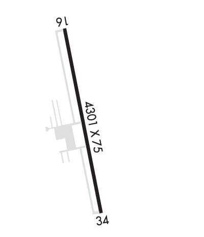
  • Runway Identifications
    Runway Identification: 16/34
    Length: 4301 ft
    Width: 75 ft
    Surface: CONCRETE
    Edge lights: Medium Intensity

    Treatment: NONE

     Runway: 16   Runway: 34
    Mag heading: 163°Mag heading: 343°
    Rwy Slope: -.15% DownRwy Slope: .15% Up
    Approach: Approach:
    Pattern: Left TrafficPattern: Left Traffic
    Markings: NONPRECISION INSTRUMENTMarkings: NONPRECISION INSTRUMENT
    Marking Condition: GOODMarking Condition: GOOD
    Arresting Dev: Arresting Dev:
    Lat & Long: N4054.0  W09759.8Lat. & Long.: N4053.3  W09759.6
    Elev: 1803.2 ft. MSLElev: 1796.9 ft. MSL
    TCH: 45 ft. AGLTCH: 44 ft. AGL
    Visual Glide Path: 3.00 degreesVisual Glide Path: 3.00 degrees
    Displaced Threshold: NoDisplaced Threshold: No
    Touchdown Zone: YESTouchdown Zone: YES
    Touchdown Elev.: 1803.4 feetTouchdown Elev.: 1801.0 feet
    Visual Glide Slope: 2-Light PAPI on LEFT side of RunwayVisual Glide Slope: 2-Light PAPI on LEFT side of Runway
    RVR Equipment: RVR Equipment:
    RVV Equipment: NORVV Equipment: NO
    Approach Lights: Approach Lights:
    REIL: NOREIL: NO
    Centerline Lights: NOCenterline Lights: NO
    Touchdown lights: NOTouchdown lights: NO
    Runway Category: Runway with a Non-precision ApproachRunway Category: Runway with a Non-precision Approach
    Declared Distances: Declared Distances:
    Obstructions: PLINEObstructions: ROAD
    Marked: NOT Marked/LightedMarked: NOT Marked/Lighted
    Clearance slope: 24:1Clearance slope: 28:1
    Obstruction height: 42 feet AGLObstruction height: 9 feet AGL
    Dist. from runway: 1219 feetDist. from runway: 457 feet
    Centerline offset: 337 right of centerlineCenterline offset:
    Comments: Comments:
    C:3/P: