Current Weather/Notams (Metars, TAFs, Notams, NWS Forecast, PIREPS, and nearby weather)
Customs Information Send updates to Support@FltPlan.com
Phone 920-968-2348
Fax 920-968-2296
Comments 8:00 a.m. - 4:00 p.m. (Central) (Monday - Friday) After hours arrivals upon request.
Database effective 05/16/2024
Airport Diagram might not be current.
|
| Facility Name: | APPLETON INTL |
| City Name: | APPLETON |
| County: | OUTAGAMIE |
| State abbrev: | WI |
| State Name: | WISCONSIN |
| | |
| Ownership: | PUBLICLY OWNED |
| Use: | OPEN TO THE PUBLIC |
| Owner's Name: | OUTAGAMIE COUNTY |
| Address: | W6390 CHALLENGER DR-SUITE 201 |
| | APPLETON, WI 54915 |
| Owner's Phone: | 920-832-5267 |
| | |
| Manager's Name: | ABE WEBER, AIRPORT DIRECTOR |
| Address: | W6390 CHALLENGER DR-SUITE 201 |
| | APPLETON, WI 54914-9119 |
| Phone: | 920-832-5267 |
| | |
| FAA Region: | GREAT LAKES |
| FAA Field Office: | CHI |
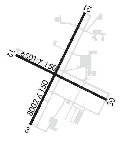
Runway Identifications
Runway Identification: 03/21Length: 8003 ft
Width: 150 ft
Surface: CONCRETE-GOOD CONDITION
Edge lights: High IntensityTreatment: GROOVED
Weight: PCN 69 /R/B/X/T
| | Runway: 03 | | Runway: 21 |
| Mag heading: | 28° | Mag heading: | 208° |
| Rwy Slope: | -.12% Down | Rwy Slope: | .12% Up |
| Approach: | ILS/DME | Approach: | |
| Pattern: | Left Traffic | Pattern: | Left Traffic |
| Markings: | PRECISION INSTRUMENT | Markings: | PRECISION INSTRUMENT |
| Marking Condition: | GOOD | Marking Condition: | GOOD |
| Arresting Dev: | | Arresting Dev: | |
| Lat & Long: | N4414.9 W08831.6 | Lat. & Long.: | N4416.1 W08830.8 |
| Elev: | 887.5 ft. MSL | Elev: | 877.9 ft. MSL |
| TCH: | 47 ft. AGL | TCH: | 47 ft. AGL |
| Visual Glide Path: | 3.00 degrees | Visual Glide Path: | 3.00 degrees |
| Displaced Threshold: | No | Displaced Threshold: | No |
| Touchdown Zone: | YES | Touchdown Zone: | YES |
| Touchdown Elev.: | 887.5 feet | Touchdown Elev.: | 879.3 feet |
| Visual Glide Slope: | 4-Light PAPI on LEFT side of Runway; OPERATES CONTINUOUSLY. | Visual Glide Slope: | 4-Light PAPI on LEFT side of Runway; OPERATES CONTINUOUSLY. PAPI RESTRICTED BYD 8.5 DEG RGT OF COURSE. |
| RVR Equipment: | TOUCHDOWN | RVR Equipment: | ROLLOUT |
| RVV Equipment: | NO | RVV Equipment: | NO |
| Approach Lights: | MALSR - 1,400 foot medium intensity approach lighting system with runway alignment indicator lights | Approach Lights: | |
| REIL: | NO | REIL: | YES |
| Centerline Lights: | NO | Centerline Lights: | NO |
| Touchdown lights: | NO | Touchdown lights: | NO |
| Runway Category: | Precision Instrument Runway | Runway Category: | Runway with a Non-precision Approach having visibility minimums greater than 3/4 mile |
| Declared Distances: | TORA:8002' TODA:8002' ASDA:8002' LDA:8002' | Declared Distances: | TORA:8002' TODA:8002' ASDA:8002' LDA:8002' |
| Obstructions: | TREE | Obstructions: | TREE |
| Marked: | NOT Marked/Lighted | Marked: | NOT Marked/Lighted |
| Clearance slope: | 39:1 | Clearance slope: | 38:1 |
| Obstruction height: | 56 feet AGL | Obstruction height: | 62 feet AGL |
| Dist. from runway: | 2400 feet | Dist. from runway: | 2600 feet |
| Centerline offset: | 200 left of centerline | Centerline offset: | 350 feet left of centerline |
| Comments: | | Comments: | |
Runway Identification: 12/30Length: 6502 ft
Width: 150 ft
Surface: CONCRETE-GOOD CONDITION
Edge lights: High IntensityTreatment: GROOVED
Weight: PCN 60 /R/B/X/T
| | Runway: 12 | | Runway: 30 |
| Mag heading: | 118° | Mag heading: | 298° |
| Rwy Slope: | -.92% Down | Rwy Slope: | .92% Up |
| Approach: | | Approach: | ILS/DME |
| Pattern: | Left Traffic | Pattern: | Left Traffic |
| Markings: | PRECISION INSTRUMENT | Markings: | PRECISION INSTRUMENT |
| Marking Condition: | GOOD | Marking Condition: | GOOD |
| Arresting Dev: | | Arresting Dev: | |
| Lat & Long: | N4415.7 W08831.8 | Lat. & Long.: | N4415.2 W08830.4 |
| Elev: | 918.0 ft. MSL | Elev: | 858.1 ft. MSL |
| TCH: | 35 ft. AGL | TCH: | 61 ft. AGL |
| Visual Glide Path: | 3.00 degrees | Visual Glide Path: | 3.00 degrees |
| Displaced Threshold: | No | Displaced Threshold: | No |
| Touchdown Zone: | YES | Touchdown Zone: | YES |
| Touchdown Elev.: | 918.0 feet | Touchdown Elev.: | 874.8 feet |
| Visual Glide Slope: | 4-Light PAPI on LEFT side of Runway | Visual Glide Slope: | 4-Light PAPI on LEFT side of Runway; OPERATES CONTINUOUSLY. |
| RVR Equipment: | | RVR Equipment: | |
| RVV Equipment: | NO | RVV Equipment: | NO |
| Approach Lights: | | Approach Lights: | MALSR - 1,400 foot medium intensity approach lighting system with runway alignment indicator lights |
| REIL: | YES | REIL: | NO |
| Centerline Lights: | NO | Centerline Lights: | NO |
| Touchdown lights: | NO | Touchdown lights: | NO |
| Runway Category: | D | Runway Category: | Precision Instrument Runway |
| Declared Distances: | TORA:6501' TODA:6501' ASDA:6501' LDA:6501' | Declared Distances: | TORA:6501' TODA:6501' ASDA:6501' LDA:6501' |
| Obstructions: | TREE | Obstructions: | |
| Marked: | NOT Marked/Lighted | Marked: | |
| Clearance slope: | 45:1 | Clearance slope: | 50:1 |
| Obstruction height: | 57 feet AGL | Obstruction height: | |
| Dist. from runway: | 2800 feet | Dist. from runway: | |
| Centerline offset: | 350 right of centerline | Centerline offset: | |
| Comments: | | Comments: | |

