Current Weather/Notams (Metars, TAFs, Notams, NWS Forecast, PIREPS, and nearby weather)
Customs Information Send updates to Support@FltPlan.com
Customs Not Available
Database effective 04/18/2024
Airport Diagram might not be current.
|
| Facility Name: | HALL-MILLER MUNI |
| City Name: | ATLANTA |
| County: | CASS |
| State abbrev: | TX |
| State Name: | TEXAS |
| | |
| Ownership: | PUBLICLY OWNED |
| Use: | OPEN TO THE PUBLIC |
| Owner's Name: | CITY OF ATLANTA |
| Address: | CITY HALL 315 N BUCKER, P.O. BOX 669 |
| | ATLANTA, TX 75551 |
| Owner's Phone: | 903-796-7153 |
| | |
| Manager's Name: | DANICA PORTER; CITY/ARPT MGR. |
| Address: | PO BOX 669 |
| | ATLANTA, TX 75551 |
| Phone: | 903-796-2192; EXT 120. |
| | |
| FAA Region: | SOUTHWEST |
| FAA Field Office: | TEX |
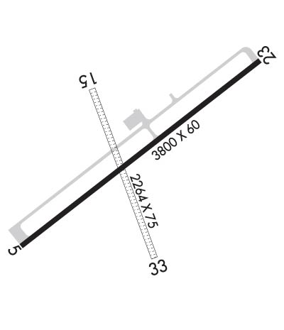
Runway Identifications
Runway Identification: 05/23Length: 3800 ft
Width: 60 ft
Surface: ASPHALT
Edge lights: Medium IntensityTreatment: NONE
| | Runway: 05 | | Runway: 23 |
| Mag heading: | 48° | Mag heading: | 228° |
| Rwy Slope: | -.32% Down | Rwy Slope: | .32% Up |
| Approach: | | Approach: | |
| Pattern: | Left Traffic | Pattern: | Left Traffic |
| Markings: | NONPRECISION INSTRUMENT | Markings: | NONPRECISION INSTRUMENT |
| Marking Condition: | GOOD | Marking Condition: | GOOD |
| Arresting Dev: | | Arresting Dev: | |
| Lat & Long: | N3306.0 W09412.0 | Lat. & Long.: | N3306.4 W09411.4 |
| Elev: | 280.3 ft. MSL | Elev: | 268.2 ft. MSL |
| TCH: | 29 ft. AGL | TCH: | 30 ft. AGL |
| Visual Glide Path: | 4.00 degrees | Visual Glide Path: | 4.00 degrees |
| Displaced Threshold: | No | Displaced Threshold: | No |
| Touchdown Zone: | YES | Touchdown Zone: | YES |
| Touchdown Elev.: | 280.3 feet | Touchdown Elev.: | 269.5 feet |
| Visual Glide Slope: | 2-Light PAPI on LEFT side of Runway | Visual Glide Slope: | 2-Light PAPI on LEFT side of Runway |
| RVR Equipment: | | RVR Equipment: | |
| RVV Equipment: | NO | RVV Equipment: | NO |
| Approach Lights: | | Approach Lights: | |
| REIL: | YES | REIL: | YES |
| Centerline Lights: | NO | Centerline Lights: | NO |
| Touchdown lights: | NO | Touchdown lights: | NO |
| Runway Category: | Runway with a Non-precision Approach having visibility minimums greater than 3/4 mile | Runway Category: | Runway with a Visual Approach |
| Declared Distances: | | Declared Distances: | |
| Obstructions: | TREES | Obstructions: | TREES |
| Marked: | NOT Marked/Lighted | Marked: | NOT Marked/Lighted |
| Clearance slope: | 1:1 | Clearance slope: | |
| Obstruction height: | 40 feet AGL | Obstruction height: | 50 feet AGL |
| Dist. from runway: | 275 feet | Dist. from runway: | 201 feet |
| Centerline offset: | 245 right of centerline | Centerline offset: | 202 feet left of centerline |
| Comments: | 25 FT TREES, 0 FT DSTC, 165 FT R. | Comments: | +40 FT TREES 0-199 FT FM THR 135-185 FT L. |
Runway Identification: 15/33Length: 2264 ft
Width: 75 ft
Surface: GRASS-GOOD CONDITION
Edge lights: Treatment: NONE
| | Runway: 15 | | Runway: 33 |
| Mag heading: | 156° | Mag heading: | 336° |
| Rwy Slope: | -.52% Down | Rwy Slope: | .52% Up |
| Approach: | | Approach: | |
| Pattern: | Left Traffic | Pattern: | Left Traffic |
| Markings: | | Markings: | |
| Marking Condition: | RWY MKD WITH 1 FT YELLOW PLASTIC PIPES. | Marking Condition: | |
| Arresting Dev: | | Arresting Dev: | |
| Lat & Long: | N3306.3 W09411.8 | Lat. & Long.: | N3305.9 W09411.7 |
| Elev: | 273.2 ft. MSL | Elev: | 261.4 ft. MSL |
| TCH: | | TCH: | |
| Visual Glide Path: | | Visual Glide Path: | |
| Displaced Threshold: | No | Displaced Threshold: | No |
| Touchdown Zone: | YES | Touchdown Zone: | YES |
| Touchdown Elev.: | 273.2 feet | Touchdown Elev.: | 273.2 feet |
| Visual Glide Slope: | | Visual Glide Slope: | |
| RVR Equipment: | | RVR Equipment: | |
| RVV Equipment: | NO | RVV Equipment: | NO |
| Approach Lights: | | Approach Lights: | |
| REIL: | NO | REIL: | NO |
| Centerline Lights: | NO | Centerline Lights: | NO |
| Touchdown lights: | NO | Touchdown lights: | NO |
| Runway Category: | Runway with a Visual Approach | Runway Category: | Runway with a Visual Approach |
| Declared Distances: | | Declared Distances: | |
| Obstructions: | TREES | Obstructions: | TREES |
| Marked: | NOT Marked/Lighted | Marked: | NOT Marked/Lighted |
| Clearance slope: | 3:1 | Clearance slope: | 1:1 |
| Obstruction height: | 80 feet AGL | Obstruction height: | 35 feet AGL |
| Dist. from runway: | 200 feet | Dist. from runway: | 0 feet |
| Centerline offset: | 80 left of centerline | Centerline offset: | 50 feet right of centerline |
| Comments: | | Comments: | |

