Current Weather/Notams (Metars, TAFs, Notams, NWS Forecast, PIREPS, and nearby weather)
Customs Information Send updates to Support@FltPlan.com
Customs Not Available
Database effective 04/18/2024
Airport Diagram might not be current.
|
| Facility Name: | HARRISON COUNTY |
| City Name: | MARSHALL |
| County: | HARRISON |
| State abbrev: | TX |
| State Name: | TEXAS |
| | |
| Ownership: | PUBLICLY OWNED |
| Use: | OPEN TO THE PUBLIC |
| Owner's Name: | HARRISON COUNTY |
| Address: | COUNTY COURTHOUSE |
| | MARSHALL, TX 75670 |
| Owner's Phone: | 903-935-8401 |
| | |
| Manager's Name: | DANIEL AIELLO |
| Address: | 2100 WARREN DR. |
| | MARSHALL, TX 75672 |
| Phone: | 903-938-1394; OR 903-938-8008. |
| | |
| FAA Region: | SOUTHWEST |
| FAA Field Office: | TEX |
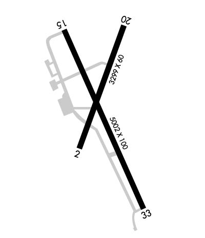
Runway Identifications
Runway Identification: 02/20Length: 3299 ft
Width: 60 ft
Surface: ASPHALT-FAIR CONDITION
Edge lights: Treatment: NONE
| | Runway: 02 | | Runway: 20 |
| Mag heading: | 19° | Mag heading: | 199° |
| Rwy Slope: | .08% Up | Rwy Slope: | -.08% Down |
| Approach: | | Approach: | |
| Pattern: | Left Traffic | Pattern: | Left Traffic |
| Markings: | BASIC | Markings: | BASIC |
| Marking Condition: | GOOD | Marking Condition: | GOOD |
| Arresting Dev: | | Arresting Dev: | |
| Lat & Long: | N3231.1 W09418.6 | Lat. & Long.: | N3231.6 W09418.3 |
| Elev: | 338.3 ft. MSL | Elev: | 341.1 ft. MSL |
| TCH: | | TCH: | |
| Visual Glide Path: | | Visual Glide Path: | |
| Displaced Threshold: | No | Displaced Threshold: | No |
| Touchdown Zone: | YES | Touchdown Zone: | YES |
| Touchdown Elev.: | 349.2 feet | Touchdown Elev.: | 349.2 feet |
| Visual Glide Slope: | | Visual Glide Slope: | |
| RVR Equipment: | | RVR Equipment: | |
| RVV Equipment: | NO | RVV Equipment: | NO |
| Approach Lights: | | Approach Lights: | |
| REIL: | NO | REIL: | NO |
| Centerline Lights: | NO | Centerline Lights: | NO |
| Touchdown lights: | NO | Touchdown lights: | NO |
| Runway Category: | Runway with a Visual Approach | Runway Category: | Runway with a Visual Approach |
| Declared Distances: | | Declared Distances: | |
| Obstructions: | TREES | Obstructions: | TREES |
| Marked: | NOT Marked/Lighted | Marked: | NOT Marked/Lighted |
| Clearance slope: | 15:1 | Clearance slope: | 4:1 |
| Obstruction height: | 81 feet AGL | Obstruction height: | 46 feet AGL |
| Dist. from runway: | 1436 feet | Dist. from runway: | 397 feet |
| Centerline offset: | | Centerline offset: | |
| Comments: | | Comments: | |
Runway Identification: 15/33Length: 5002 ft
Width: 100 ft
Surface: ASPHALT
Edge lights: Medium IntensityTreatment: NONE
| | Runway: 15 | | Runway: 33 |
| Mag heading: | 154° | Mag heading: | 334° |
| Rwy Slope: | -.73% Down | Rwy Slope: | .73% Up |
| Approach: | | Approach: | |
| Pattern: | Left Traffic | Pattern: | Left Traffic |
| Markings: | NONPRECISION INSTRUMENT | Markings: | NONPRECISION INSTRUMENT |
| Marking Condition: | GOOD | Marking Condition: | GOOD |
| Arresting Dev: | | Arresting Dev: | |
| Lat & Long: | N3231.6 W09418.7 | Lat. & Long.: | N3230.8 W09418.3 |
| Elev: | 355.9 ft. MSL | Elev: | 319.5 ft. MSL |
| TCH: | | TCH: | |
| Visual Glide Path: | | Visual Glide Path: | |
| Displaced Threshold: | No | Displaced Threshold: | No |
| Touchdown Zone: | YES | Touchdown Zone: | YES |
| Touchdown Elev.: | 357.0 feet | Touchdown Elev.: | 348.9 feet |
| Visual Glide Slope: | | Visual Glide Slope: | |
| RVR Equipment: | | RVR Equipment: | |
| RVV Equipment: | NO | RVV Equipment: | NO |
| Approach Lights: | | Approach Lights: | |
| REIL: | YES | REIL: | YES |
| Centerline Lights: | NO | Centerline Lights: | NO |
| Touchdown lights: | NO | Touchdown lights: | NO |
| Runway Category: | Runway with a Non-precision Approach having visibility minimums greater than 3/4 mile | Runway Category: | Runway with a Non-precision Approach having visibility minimums greater than 3/4 mile |
| Declared Distances: | | Declared Distances: | |
| Obstructions: | TREES | Obstructions: | TREES |
| Marked: | NOT Marked/Lighted | Marked: | NOT Marked/Lighted |
| Clearance slope: | 16:1 | Clearance slope: | 21:1 |
| Obstruction height: | 96 feet AGL | Obstruction height: | 31 feet AGL |
| Dist. from runway: | 1800 feet | Dist. from runway: | 870 feet |
| Centerline offset: | 250 left of centerline | Centerline offset: | 280 feet left of centerline |
| Comments: | | Comments: | |

