Current Weather/Notams (Metars, TAFs, Notams, NWS Forecast, PIREPS, and nearby weather)
Customs Information Send updates to Support@FltPlan.com
Customs Not Available
Database effective 05/16/2024
Airport Diagram might not be current.
|
| Facility Name: | TRI-COUNTY AT HENRY JOYNER FLD |
| City Name: | AHOSKIE |
| County: | HERTFORD |
| State abbrev: | NC |
| State Name: | NORTH CAROLINA |
| | |
| Ownership: | PUBLICLY OWNED |
| Use: | OPEN TO THE PUBLIC |
| Owner's Name: | TRI-COUNTY AIRPORT AUTH. |
| Address: | 140 TRI-COUNTY AIRPORT RD |
| | AULANDER, NC 27805 |
| Owner's Phone: | 252-345-9962 |
| | |
| Manager's Name: | HENRY JOYNER |
| Address: | 140 TRI-COUNTY AIRPORT RD |
| | AULANDER, NC 27805 |
| Phone: | 252-345-0111; FOR ARPT AMGR AFTER HOURS CALL 252-395-0822. |
| | |
| FAA Region: | SOUTHERN |
| FAA Field Office: | MEM |
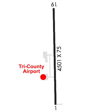
Runway Identifications
Runway Identification: 01/19Length: 4501 ft
Width: 75 ft
Surface: ASPHALT-GOOD CONDITION
Edge lights: Medium IntensityTreatment: NONE
| | Runway: 01 | | Runway: 19 |
| Mag heading: | 8° | Mag heading: | 188° |
| Rwy Slope: | .00% Down | Rwy Slope: | .00% Up |
| Approach: | | Approach: | |
| Pattern: | Left Traffic | Pattern: | Left Traffic |
| Markings: | NONPRECISION INSTRUMENT | Markings: | NONPRECISION INSTRUMENT |
| Marking Condition: | GOOD | Marking Condition: | GOOD |
| Arresting Dev: | | Arresting Dev: | |
| Lat & Long: | N3617.5 W07710.2 | Lat. & Long.: | N3618.2 W07710.3 |
| Elev: | 66.5 ft. MSL | Elev: | 66.3 ft. MSL |
| TCH: | 44 ft. AGL | TCH: | 40 ft. AGL |
| Visual Glide Path: | 3.17 degrees | Visual Glide Path: | 3.00 degrees |
| Displaced Threshold: | No | Displaced Threshold: | No |
| Touchdown Zone: | YES | Touchdown Zone: | YES |
| Touchdown Elev.: | 66.6 feet | Touchdown Elev.: | 66.5 feet |
| Visual Glide Slope: | 2-Light PAPI on LEFT side of Runway | Visual Glide Slope: | 2-Light PAPI on LEFT side of Runway |
| RVR Equipment: | | RVR Equipment: | |
| RVV Equipment: | NO | RVV Equipment: | NO |
| Approach Lights: | | Approach Lights: | |
| REIL: | YES | REIL: | YES |
| Centerline Lights: | NO | Centerline Lights: | NO |
| Touchdown lights: | NO | Touchdown lights: | NO |
| Runway Category: | Runway with a Non-precision Approach having visibility minimums greater than 3/4 mile | Runway Category: | Runway with a Non-precision Approach having visibility minimums greater than 3/4 mile |
| Declared Distances: | | Declared Distances: | |
| Obstructions: | ROAD | Obstructions: | TREES |
| Marked: | NOT Marked/Lighted | Marked: | NOT Marked/Lighted |
| Clearance slope: | 15:1 | Clearance slope: | 8:1 |
| Obstruction height: | 15 feet AGL | Obstruction height: | 22 feet AGL |
| Dist. from runway: | 437 feet | Dist. from runway: | 383 feet |
| Centerline offset: | | Centerline offset: | 236 feet right of centerline |
| Comments: | | Comments: | DUE TO 16 FT TREES 0-200 FT FM THLD OFFSET 168 FT L OF CNTRLN AND 10 FT TREES 0-200 FT FM THLD OFFSET 113 FT R OF CNTRLN. |


