Current Weather/Notams (Metars, TAFs, Notams, NWS Forecast, PIREPS, and nearby weather)
Customs Information Send updates to Support@FltPlan.com
Customs Not Available
Database effective 05/16/2024
Airport Diagram might not be current.
|
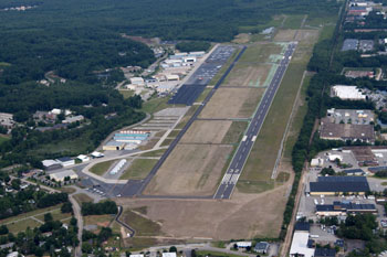
| Facility Name: | BOIRE FLD |
| City Name: | NASHUA |
| County: | HILLSBOROUGH |
| State abbrev: | NH |
| State Name: | NEW HAMPSHIRE |
| | |
| Ownership: | PUBLICLY OWNED |
| Use: | OPEN TO THE PUBLIC |
| Owner's Name: | NASHUA AIRPORT AUTHORITY |
| Address: | 93 PERIMETER RD |
| | NASHUA, NH 03063 |
| Owner's Phone: | 603-882-0661 |
| | |
| Manager's Name: | CHRIS LYNCH |
| Address: | 93 PERIMETER RD |
| | NASHUA, NH 03063 |
| Phone: | 603-882-0661 |
| | |
| FAA Region: | NEW ENGLAND |
| FAA Field Office: | NONE |
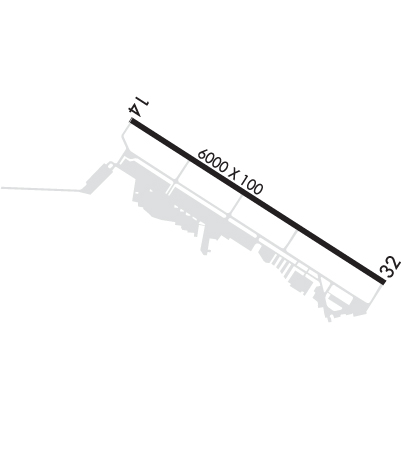
Runway Identifications
Runway Identification: 14/32Length: 6000 ft
Width: 100 ft
Surface: ASPHALT
Edge lights: High IntensityTreatment: GROOVED
| | Runway: 14 | | Runway: 32 |
| Mag heading: | 139° | Mag heading: | 319° |
| Rwy Slope: | -.14% Down | Rwy Slope: | .14% Up |
| Approach: | ILS | Approach: | |
| Pattern: | Left Traffic | Pattern: | Left Traffic |
| Markings: | PRECISION INSTRUMENT | Markings: | NONPRECISION INSTRUMENT |
| Marking Condition: | GOOD | Marking Condition: | GOOD |
| Arresting Dev: | | Arresting Dev: | |
| Lat & Long: | N4247.2 W07131.4 | Lat. & Long.: | N4246.7 W07130.3 |
| Elev: | 200.4 ft. MSL | Elev: | 192.0 ft. MSL |
| TCH: | 45 ft. AGL | TCH: | 45 ft. AGL |
| Visual Glide Path: | 3.00 degrees | Visual Glide Path: | 3.00 degrees |
| Displaced Threshold: | No | Displaced Threshold: | 350 feet |
| Touchdown Zone: | YES | Touchdown Zone: | YES |
| Touchdown Elev.: | 200.4 feet | Touchdown Elev.: | 192.5 feet |
| Visual Glide Slope: | 4-Light PAPI on RIGHT side of Runway | Visual Glide Slope: | 4-Light PAPI on LEFT side of Runway |
| RVR Equipment: | | RVR Equipment: | |
| RVV Equipment: | NO | RVV Equipment: | NO |
| Approach Lights: | MALSR - 1,400 foot medium intensity approach lighting system with runway alignment indicator lights | Approach Lights: | |
| REIL: | NO | REIL: | YES |
| Centerline Lights: | NO | Centerline Lights: | NO |
| Touchdown lights: | NO | Touchdown lights: | NO |
| Runway Category: | Precision Instrument Runway | Runway Category: | Runway with a Non-precision Approach having visibility minimums greater than 3/4 mile |
| Declared Distances: | TORA:6000' TODA:6000' ASDA:5650' LDA:5650' | Declared Distances: | TORA:6000' TODA:6000' ASDA:6000' LDA:5650' |
| Obstructions: | TREE | Obstructions: | TREE |
| Marked: | NOT Marked/Lighted | Marked: | NOT Marked/Lighted |
| Clearance slope: | 13:1 | Clearance slope: | 18:1; APCH SLOPE 44:1 TO DTHR. |
| Obstruction height: | 65 feet AGL | Obstruction height: | 61 feet AGL |
| Dist. from runway: | 1050 feet | Dist. from runway: | 1337 feet |
| Centerline offset: | 606 left of centerline; TREES LCTD ALG RAIL LN N OF RWY. | Centerline offset: | 358 feet left of centerline |
| Comments: | | Comments: | |