| ||||||||||||||||||||||||||||||||||||||||||||||||||||||||||||||||||||
| ||||||||||||||||||||||||||||||||||||||||||||||||||||||||||||||||||||
| ||||||||||||||||||||||||||||||||||||||||||||||||||||||||||||||||||||
| ||||||||||||||||||||||||||||||||||||||||||||||||||||||||||||||||||||
| FBOs at nearby airports who want your business: | |||||||||||||||||
| |||||||||||||||||
| Rwy | Rwy | |||||||
| 8006x100 | 8006' | 111.15 - 150° | 8006x100 | 7006' | ||||
| Runway ID | Single Wheel | Double Wheel | Double Tandem Wheel | Dual Double Wheel |
| 00X | N/A | N/A | N/A | N/A |
| 15/33 | 80,000 | 100,000 | 160,000 | N/A |
| These numbers are Advisory and are not limits. The Airport Manager should have more accurate Weight Limits | ||||
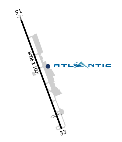 Airport Diagram might not be current. | |
| Facility Name: | ASPEN-PITKIN COUNTY/SARDY FLD |
| City Name: | ASPEN |
| County: | PITKIN |
| State abbrev: | CO |
| State Name: | COLORADO |
| Ownership: | PUBLICLY OWNED |
| Use: | OPEN TO THE PUBLIC |
| Owner's Name: | PITKIN COUNTY |
| Address: | 506 E MAIN |
| ASPEN, CO 81611 | |
| Owner's Phone: | 970-920-5200 |
| Manager's Name: | DAN BARTHOLOMEW |
| Address: | 0233 E AIRPORT RD |
| ASPEN, CO 81611 | |
| Phone: | (970) 429-2851 |
| FAA Region: | NORTHWEST MOUNTAIN |
| FAA Field Office: | DEN |
| Date | Sunrise | Sunset |
|---|---|---|
| 04/17/24 Wednesday | 6:27 | 19:48 |
| 04/18/24 Thursday | 6:25 | 19:49 |
| 04/19/24 Friday | 6:24 | 19:50 |
| 04/20/24 Saturday | 6:22 | 19:51 |
| 04/21/24 Sunday | 6:21 | 19:52 |
| 04/22/24 Monday | 6:20 | 19:53 |
| 04/23/24 Tuesday | 6:18 | 19:54 |
| 04/24/24 Wednesday | 6:17 | 19:55 |
| 04/25/24 Thursday | 6:16 | 19:56 |
| 04/26/24 Friday | 6:14 | 19:57 |
| 04/27/24 Saturday | 6:13 | 19:58 |
| 04/28/24 Sunday | 6:12 | 19:59 |
| 04/29/24 Monday | 6:10 | 20:00 |
| 04/30/24 Tuesday | 6:09 | 20:01 |
| Airport Attendance Schedule | 7 Days A Week 0700-2300 |
| Airport Status | OPERATIONAL (This Status can change at any time - please check NOTAMS) |
| Airport Lighting Schedule | WHEN ATCT CLSD ACTVT MALSF RWY 15; REIL RWY 33; PAPI RWY 15; MIRL RWY 15/33 - CTAF. REIL RWY 15 - ATCT CTL, OPER DAY VFR ONLY.; DUSK-2300 |
| Airport Storage Available | Tie Downs, Hanger |
| Extra Services Available | Air Freight, Air Ambulance, Charter, Glider, Flight Instruction, Parachute Jumping, Aircraft Rental, Glider Towing |
| Wind Indicator | YES - (lighted) |
| Control Tower | YES |
| CTAF Frequency | 118.850 |
| Unicom Frequency | 122.950 |
| Rotating Beacon Color | WG |
| Segmented Circle | YES |
| Landing Fee | YES |
| Airport Inspected | FEDERAL - performed by FAA AIRPORTS FIELD PERSONNEL |
| Inspection Date | 07/26/2023 |
| Type of Fuel Available | Grade 100LL, JET A-1 (icing inhibitor, freeze point -50C) |
| Airframe Repair Service | MINOR; FOR ACFT SVCS CTC UNICOM. |
| Power Plant Repair Service | MINOR |
| Latitude | N3913.3 |
| Longitude | W10652.1 (ESTIMATED) |
| Arpt Elevation | 7837ft (SURVEYED) |
| Magnetic Variation | 09E |
| 3 miles NW | of ASPEN |
| Traffic Pattern Altitude | TPA FOR LGT ACFT 1185 AGL; TPA FOR HEAVY ACFT 1685 AGL. |
| Sectional Chart | DENVER |
| Operations (Reported) | Yearly | Avg. Daily |
|---|---|---|
| General Aviation Transient | 15332 | 42 |
| General Aviation Local | 4498 | 12 |
| Air Taxi | 11354 | 31 |
| Commerical | 7000 | 19 |
| Commuter | 0 | 0 |
| Military | 400 | 1 |
| Aircraft based on Field | |
|---|---|
| General Aviation Singles | 66 |
| General Aviation Multi | 10 |
| Jet Aircraft | 13 |
| General Aviation Helicopters | 5 |
| Military Aircraft | 0 |
| Gliders | 1 |
| Ultralights | 0 |
| FSS on field | NO |
| FSS tie-in | DENVER |
| FSS Phone | 1-800-WX-BRIEF |
| Who issues Notams | ASE |
| Notam D service at airport | YES |
| ARTCC Name | DENVER |
| Airport Certification | AIRPORT RECEIVING SCHEDULED AIR CARRIER SERVICE FROM CARRIERS CERTIFICATED BY THE CIVIL AERONAUTICS BOARD |
| Aircraft Rescue & Firefighting Index | AIRPORT HAS A CERTIFICATE UNDER CFR PART 139 |
| Airport of Entry | No |
| Custom Landing Rights | No |
| Joint Civil/Military | No |
| Military Landing rights | YES |
| NATIONAL PLAN OF INTEGRATED AIRPORT SYSTEMS (NPIAS) |
| GRANT AGREEMENTS UNDER FAAP/ADAP/AIP |
| ASSURANCES PURSUANT TO TITLE VI, CIVIL RIGHTS ACT OF 1964 |
| ARPT CLSD 2300-0700. |
| TERRAIN WILL NOT ALLOW FOR NORMAL TFC PATTERNS. HIGH RATES OF DESCENT MAY BE RQRD DUE TO TERRAIN & LOCAL PROCS. |
| ARPT LOCATED IN HIGH MOUNTAIN VALLEY WITH MOUNTAINOUS TERRAIN FROM 12500 - 14000 FT MSL IN NEAR PROXIMITY TO ARPT; NUMEROUS UNLIGHTED OBSTRUCTIONS. ALL ADVERSE WEATHER SITUATIONS MAGNIFIED IN MOUNTAINS. OPERATIONS DURING PERIODS OF REDUCED VISIBILITY DISCOURAGED FOR PILOTS UNFAMILIAR WITH AREA. |
| UNCONTROLLED TRAFFIC ON THE RAMPS. RY 33 RUN-UP AREA NOT VISIBLE FROM ATCT. |
| FOR ALL GA OPNS BTWN 30 MIN AFT SS TO 2300 THE FOLLOWING APPLIES: ACFT EQUIPPED AS RQRD UNDER FAR 91.205(D) FOR INST FLT - PILOT IS INST RATED; VFR PIC HAS COMPLETED AT LEAST ONE TKOF OR LDNG IN THE PRECEDING 12 MONTHS AT ASE. IFR: EXECUTE APCH/DEP PROCEDURES WITH ATC CLNC. |
| UNIQUE VFR DEP PROCEDURES EXIST. CALL ARPT OPS 970-920-5760; OR FBO 970-920-2016 FOR MORE INFO. |
| (A106) ACFT REQUIRING IFR SHOULD FILE FLIGHT PLAN WITH FLIGHT SERVICE 45 MIN PRIOR TO ESTD DEP. |
| UNLESS CEILINGS ARE AT LEAST 2000 FT ABOVE HIGHEST TRRN & VIS IS 15 MILES OR MORE; MOUNTAIN FLYING IS NOT RECOMMENDED. |
| PPR FOR TKOF ON RY 15. CTC FBO 970-920-2016. |
| ARPT RESTRICTED TO MAXIMUM ACFT WINGSPAN OF 95 FT. |
| PILOTS ARE RESPONSIBLE FOR PASSENGERS IN RAMP AREA. PEDESTRIANS AND VEHICLES CANNOT ENTER TWYS WITHOUT ATC CLEARANCE. STAY ON THE SOLID SIDE OF THE RED BOUNDARY MARKING LINE. |
| COLD TEMPERATURE AIRPORT. ALTITUDE CORRECTION REQUIRED AT OR BELOW -22C. |
| BIRDS AND OTHER WILDLIFE ON AND INVOF RWYS. WATCH FOR WILDLIFE ON OR NEAR RWYS |
| ALL ARRIVING AIRCRAFT FRM 2000 TO 2300L MUST ANNOUNCE CTAF 118.85 WHEN THEY ARE 20, 15, 10 AND 5 MILES OUT AND ON SHORT FINAL. EQUIPMENT MAY BE ON THE RWY. |
| ALL COMMERCIAL ACFT ADVISE PRIOR TO PUSHBACK ONTO TWY-A. |
| CAUTION: HIGH TFC INTXN - ACFT RTNELY HOLD SHORT OF TWY A4 ON TWY A WHEN INBD TO TRML OR GA RAMP. |
| WIND CONES LCTD 60 FT WEST OF TWY A CNTRLN. |
| DUE TO POOR VISIBILITY IN VALLEY, USE LNDG LGTS IN TFC PAT. |
| REVIEW OF AIRPLANE PERFORMANCE RCMDD INCLUDING DA; WEIGHT & BALANCE AND CLIMB PERFORMANCE. |
| HANG GLIDERS; PARA GLIDERS; HOT AIR BALLOON & GLIDER OPNS ON & INVOF ARPT UP TO 18000 FT MSL. |
| NOISE ABATEMENT PROCEDURES IN EFFECT. CTC ARPT OPS 970-920-5760 EXT 0. |
| FBO REQUIRES 2 HRS ADVANCE NOTICE FOR STAGING ACFT PRIOR TO DEP. |
| DUE TO HIGH APCH MINIMUMS PILOTS MAY NEED AN IFR ALTERNATE EVEN THOUGH WEATHER IS FORECAST TO BE HIGHER THAN 2000-3. |
| RWY 00X RWY EXISTS TO SUPPORT THE PKN LDA ASSOC WITH THIS ARPT. |
Airport Communications & Frequencies:
| |||||||||||||||||||||||||||||
| Runway: 15 | Runway: 33 | ||
| Mag heading: | 151° | Mag heading: | 331° |
| Rwy Slope: | 1.97% Up | Rwy Slope: | -1.97% Down |
| Approach: | LOC/DME | Approach: | |
| Pattern: | Left Traffic | Pattern: | Right Traffic |
| Markings: | NONPRECISION INSTRUMENT | Markings: | NONPRECISION INSTRUMENT |
| Marking Condition: | GOOD | Marking Condition: | GOOD |
| Arresting Dev: | Arresting Dev: | ||
| Lat & Long: | N3913.9 W10652.4 | Lat. & Long.: | N3912.7 W10651.8 |
| Elev: | 7680.3 ft. MSL | Elev: | 7837.9 ft. MSL |
| TCH: | 55 ft. AGL | TCH: | |
| Visual Glide Path: | 3.50 degrees | Visual Glide Path: | |
| Displaced Threshold: | No | Displaced Threshold: | 1000 feet |
| Touchdown Zone: | YES | Touchdown Zone: | YES |
| Touchdown Elev.: | 7737.2 feet | Touchdown Elev.: | 7820.5 feet |
| Visual Glide Slope: | 4-Light PAPI on LEFT side of Runway; PAPI UNUSBL BYD 4 NM FM RWY THR & BYD 7 DEGS RIGHT OF RWY CNTRLN. | Visual Glide Slope: | |
| RVR Equipment: | RVR Equipment: | ||
| RVV Equipment: | NO | RVV Equipment: | NO |
| Approach Lights: | MALSF - 1,400 foot medium intensity approach lighting system with sequenced flashers | Approach Lights: | |
| REIL: | YES | REIL: | YES |
| Centerline Lights: | NO | Centerline Lights: | NO |
| Touchdown lights: | NO | Touchdown lights: | NO |
| Runway Category: | Runway with a Non-precision Approach having visibility minimums greater than 3/4 mile | Runway Category: | Runway with a Visual Approach |
| Declared Distances: | TORA:7006' TODA:7006' ASDA:7006' LDA:7006' | Declared Distances: | TORA:8006' TODA:8006' ASDA:8006' LDA:7006' |
| Obstructions: | Obstructions: | ROAD | |
| Marked: | Marked: | NOT Marked/Lighted | |
| Clearance slope: | 34:1 | Clearance slope: | 40:1 |
| Obstruction height: | Obstruction height: | 22 feet AGL | |
| Dist. from runway: | Dist. from runway: | 1100 feet | |
| Centerline offset: | Centerline offset: | 550 feet left of centerline | |
| Comments: | Comments: |