Current Weather/Notams (Metars, TAFs, Notams, NWS Forecast, PIREPS, and nearby weather)
Customs Information Send updates to Support@FltPlan.com
Customs Not Available
Database effective 05/16/2024
Airport Diagram might not be current.
|
| Facility Name: | LAKELAND/NOBLE F LEE MEML FLD |
| City Name: | MINOCQUA-WOODRUFF |
| County: | VILAS |
| State abbrev: | WI |
| State Name: | WISCONSIN |
| | |
| Ownership: | PUBLICLY OWNED |
| Use: | OPEN TO THE PUBLIC |
| Owner's Name: | LAKELAND AIRPORT COMMISSION; TOWNS OF ARBOR VITAE, LAC DU FLAMBEAU, MINOCQUA, WOODRUFF. |
| Address: | 1545 N. FARMING RD. |
| | WOODRUFF, WI 54568 |
| Owner's Phone: | (715) 356-4340 |
| | |
| Manager's Name: | JON SCHMITZ |
| Address: | 1545 N. FARMING RD; EMAIL ADDRESS: LAKELANDAIRPORT@FRONTIER.COM (ALL LOWER CASE) |
| | WOODRUFF, WI 54568 |
| Phone: | (715) 356-3891 |
| | |
| FAA Region: | GREAT LAKES |
| FAA Field Office: | CHI |
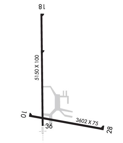
Runway Identifications
Runway Identification: 10/28Length: 3602 ft
Width: 75 ft
Surface: ASPHALT-GOOD CONDITION
Edge lights: Medium IntensityTreatment: NONE
| | Runway: 10 | | Runway: 28 |
| Mag heading: | 103° | Mag heading: | 283° |
| Rwy Slope: | .01% Up | Rwy Slope: | -.01% Down |
| Approach: | | Approach: | |
| Pattern: | Left Traffic | Pattern: | Left Traffic |
| Markings: | NONPRECISION INSTRUMENT | Markings: | NONPRECISION INSTRUMENT |
| Marking Condition: | GOOD | Marking Condition: | GOOD |
| Arresting Dev: | | Arresting Dev: | |
| Lat & Long: | N4555.5 W08944.1 | Lat. & Long.: | N4555.4 W08943.3 |
| Elev: | 1622.5 ft. MSL | Elev: | 1622.8 ft. MSL |
| TCH: | | TCH: | 37 ft. AGL |
| Visual Glide Path: | | Visual Glide Path: | 3.00 degrees |
| Displaced Threshold: | No | Displaced Threshold: | No |
| Touchdown Zone: | YES | Touchdown Zone: | YES |
| Touchdown Elev.: | 1624.5 feet | Touchdown Elev.: | 1624.5 feet |
| Visual Glide Slope: | | Visual Glide Slope: | 2-Light PAPI on LEFT side of Runway |
| RVR Equipment: | | RVR Equipment: | |
| RVV Equipment: | NO | RVV Equipment: | NO |
| Approach Lights: | | Approach Lights: | |
| REIL: | NO | REIL: | YES |
| Centerline Lights: | NO | Centerline Lights: | NO |
| Touchdown lights: | NO | Touchdown lights: | NO |
| Runway Category: | Runway with a Visual Approach | Runway Category: | Runway with a Non-precision Approach |
| Declared Distances: | | Declared Distances: | |
| Obstructions: | TREES | Obstructions: | |
| Marked: | NOT Marked/Lighted | Marked: | |
| Clearance slope: | 11:1 | Clearance slope: | 20:1 |
| Obstruction height: | 71 feet AGL | Obstruction height: | |
| Dist. from runway: | 1000 feet | Dist. from runway: | |
| Centerline offset: | 190 right of centerline | Centerline offset: | |
| Comments: | | Comments: | |
Runway Identification: 18/36Length: 5150 ft
Width: 100 ft
Surface: ASPHALT-GOOD CONDITION
Edge lights: High IntensityTreatment: NONE
| | Runway: 18 | | Runway: 36 |
| Mag heading: | 181° | Mag heading: | 1° |
| Rwy Slope: | -.11% Down | Rwy Slope: | .11% Up |
| Approach: | | Approach: | LOCALIZER |
| Pattern: | Left Traffic | Pattern: | Left Traffic |
| Markings: | NONPRECISION INSTRUMENT | Markings: | NONPRECISION INSTRUMENT |
| Marking Condition: | FAIR | Marking Condition: | FAIR |
| Arresting Dev: | | Arresting Dev: | |
| Lat & Long: | N4556.3 W08944.0 | Lat. & Long.: | N4555.4 W08944.0 |
| Elev: | 1629.5 ft. MSL | Elev: | 1623.6 ft. MSL |
| TCH: | 44 ft. AGL | TCH: | 45 ft. AGL |
| Visual Glide Path: | 3.00 degrees | Visual Glide Path: | 3.00 degrees |
| Displaced Threshold: | No | Displaced Threshold: | No |
| Touchdown Zone: | YES | Touchdown Zone: | YES |
| Touchdown Elev.: | 1629.5 feet | Touchdown Elev.: | 1627.3 feet |
| Visual Glide Slope: | 4-BOX VASI ON LEFT SIDE OF RUNWAY | Visual Glide Slope: | 4-BOX VASI ON LEFT SIDE OF RUNWAY |
| RVR Equipment: | | RVR Equipment: | |
| RVV Equipment: | NO | RVV Equipment: | NO |
| Approach Lights: | | Approach Lights: | MALSR - 1,400 foot medium intensity approach lighting system with runway alignment indicator lights |
| REIL: | YES | REIL: | NO |
| Centerline Lights: | NO | Centerline Lights: | NO |
| Touchdown lights: | NO | Touchdown lights: | NO |
| Runway Category: | Runway with a Non-precision Approach having visibility minimums greater than 3/4 mile | Runway Category: | Runway with a Non-precision Approach having visibility minimums greater than 3/4 mile |
| Declared Distances: | | Declared Distances: | |
| Obstructions: | TREES | Obstructions: | |
| Marked: | NOT Marked/Lighted | Marked: | |
| Clearance slope: | 29:1 | Clearance slope: | 34:1 |
| Obstruction height: | 100 feet AGL | Obstruction height: | |
| Dist. from runway: | 3150 feet | Dist. from runway: | |
| Centerline offset: | 400 left of centerline | Centerline offset: | |
| Comments: | | Comments: | |

