Current Weather/Notams (Metars, TAFs, Notams, NWS Forecast, PIREPS, and nearby weather)
Customs Information Send updates to Support@FltPlan.com
Customs Not Available
Database effective 05/16/2024
Airport Diagram might not be current. Facility Name: AURORA MUNI City Name: CHICAGO/AURORA County: KANE State abbrev: IL State Name: ILLINOIS Ownership: PUBLICLY OWNED Use: OPEN TO THE PUBLIC Owner's Name: CITY OF AURORA Address: 44 E. DOWNER PLACE AURORA, IL 60507 Owner's Phone: (630) 256-3120 Manager's Name: STEVE ANDRAS Address: 43W 636 US30 SUGAR GROVE, IL 60554 Phone: (630) 256-3120 FAA Region: GREAT LAKES FAA Field Office: CHI
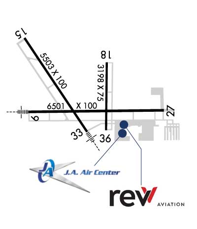
Runway Identifications Help
Runway Identification: 09/27 Length: 6501 ftWidth: 100 ftSurface: CONCRETE-GOOD CONDITIONEdge lights: High Intensity Treatment: GROOVED Runway: 09 Runway: 27 Mag heading: 90° Mag heading: 270° Rwy Slope: .01% Up Rwy Slope: -.01% Down Approach: ILS Approach: Pattern: Left Traffic Pattern: Left Traffic Markings: PRECISION INSTRUMENT Markings: PRECISION INSTRUMENT Marking Condition: GOOD Marking Condition: GOOD Arresting Dev: Arresting Dev: Lat & Long: N4146.2 W08829.1 Lat. & Long.: N4146.2 W08827.7 Elev: 706.8 ft. MSL Elev: 707.2 ft. MSL TCH: 45 ft. AGL TCH: 45 ft. AGL Visual Glide Path: 3.00 degrees Visual Glide Path: 3.00 degrees Displaced Threshold: No Displaced Threshold: No Touchdown Zone: YES Touchdown Zone: YES Touchdown Elev.: 706.8 feet Touchdown Elev.: 707.3 feet Visual Glide Slope: 4-Light PAPI on LEFT side of Runway Visual Glide Slope: 4-Light PAPI on LEFT side of Runway RVR Equipment: RVR Equipment: RVV Equipment: NO RVV Equipment: NO Approach Lights: MALSR - 1,400 foot medium intensity approach lighting system with runway alignment indicator lights Approach Lights: REIL: NO REIL: YES Centerline Lights: NO Centerline Lights: NO Touchdown lights: NO Touchdown lights: NO Runway Category: Precision Instrument Runway Runway Category: D Declared Distances: ASDA:6972' Declared Distances: ASDA:6460' LDA:6460'
Runway Identification: 15/33 Length: 5503 ftWidth: 100 ftSurface: CONCRETE-GOOD CONDITIONEdge lights: High Intensity Treatment: GROOVED Runway: 15 Runway: 33 Mag heading: 148° Mag heading: 328° Rwy Slope: -.25% Down Rwy Slope: .25% Up Approach: Approach: LOC/DME Pattern: Left Traffic Pattern: Left Traffic Markings: PRECISION INSTRUMENT Markings: PRECISION INSTRUMENT Marking Condition: GOOD Marking Condition: GOOD Arresting Dev: Arresting Dev: Lat & Long: N4146.8 W08829.2 Lat. & Long.: N4146.0 W08828.5 Elev: 712.0 ft. MSL Elev: 698.5 ft. MSL TCH: 34 ft. AGL TCH: 48 ft. AGL Visual Glide Path: 3.00 degrees Visual Glide Path: 3.00 degrees Displaced Threshold: No Displaced Threshold: No Touchdown Zone: YES Touchdown Zone: YES Touchdown Elev.: 712.0 feet Touchdown Elev.: 705.4 feet Visual Glide Slope: 4-Light PAPI on LEFT side of Runway Visual Glide Slope: 4-Light PAPI on LEFT side of Runway RVR Equipment: RVR Equipment: RVV Equipment: NO RVV Equipment: NO Approach Lights: Approach Lights: MALSR - 1,400 foot medium intensity approach lighting system with runway alignment indicator lights REIL: YES REIL: NO Centerline Lights: NO Centerline Lights: NO Touchdown lights: NO Touchdown lights: NO Runway Category: D Runway Category: D Declared Distances: Declared Distances: Obstructions: TREE Obstructions: TREE Marked: NOT Marked/Lighted Marked: NOT Marked/Lighted Clearance slope: 19:1 Clearance slope: 37:1 Obstruction height: 44 feet AGL Obstruction height: 88 feet AGL Dist. from runway: 1039 feet Dist. from runway: 3503 feet Centerline offset: 540 left of centerline Centerline offset: 924 feet left of centerline Comments: Comments:
Runway Identification: 18/36 Length: 3198 ftWidth: 75 ftSurface: ASPHALT-POOR CONDITIONEdge lights: Medium Intensity Treatment: NONE Runway: 18 Runway: 36 Mag heading: 181° Mag heading: 1° Rwy Slope: .01% Up Rwy Slope: -.01% Down Approach: Approach: Pattern: Left Traffic Pattern: Left Traffic Markings: BASIC Markings: NONPRECISION INSTRUMENT Marking Condition: FAIR Marking Condition: FAIR Arresting Dev: Arresting Dev: Lat & Long: N4146.6 W08828.3 Lat. & Long.: N4146.1 W08828.3 Elev: 700.1 ft. MSL Elev: 700.4 ft. MSL TCH: 30 ft. AGL TCH: 34 ft. AGL Visual Glide Path: 3.00 degrees Visual Glide Path: 3.00 degrees Displaced Threshold: No Displaced Threshold: No Touchdown Zone: YES Touchdown Zone: YES Touchdown Elev.: 702.7 feet Touchdown Elev.: 702.7 feet Visual Glide Slope: 4-Light PAPI on LEFT side of Runway Visual Glide Slope: 4-BOX VASI ON LEFT SIDE OF RUNWAY RVR Equipment: RVR Equipment: RVV Equipment: NO RVV Equipment: NO Approach Lights: Approach Lights: REIL: YES REIL: YES Centerline Lights: NO Centerline Lights: NO Touchdown lights: NO Touchdown lights: NO Runway Category: Runway with a Visual Approach Runway Category: Runway with a Non-precision Approach Declared Distances: Declared Distances: Obstructions: POLE Obstructions: TREE Marked: NOT Marked/Lighted Marked: NOT Marked/Lighted Clearance slope: 23:1 Clearance slope: 40:1 Obstruction height: 39 feet AGL Obstruction height: 73 feet AGL Dist. from runway: 1129 feet Dist. from runway: 3140 feet Centerline offset: 296 right of centerline Centerline offset: 497 feet right of centerline Comments: RISING GROUND +6 FEET. Comments: