
| ||||||||||||||||||||||||||||||||||||||||||||
| ||||||||||||||||||||||||||||||||||||||||||||
| ||||||||||||||||||||||||||||||||||||||||||||
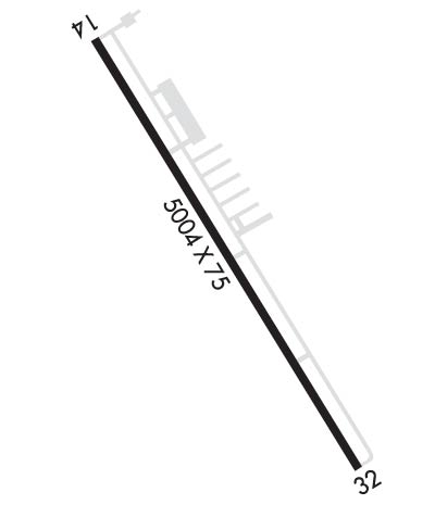
| Rwy | Rwy | |||||||
| 5004x75 | 5004' | 5004x75 | 5004' | |||||
| Runway ID | Single Wheel | Double Wheel | Double Tandem Wheel | Dual Double Wheel |
| 14/32 | 22,000 | N/A | N/A | N/A |
| These numbers are Advisory and are not limits. The Airport Manager should have more accurate Weight Limits | ||||
 Airport Diagram might not be current. | |
| Facility Name: | WHARTON RGNL |
| City Name: | WHARTON |
| County: | WHARTON |
| State abbrev: | TX |
| State Name: | TEXAS |
| Ownership: | PUBLICLY OWNED |
| Use: | OPEN TO THE PUBLIC |
| Owner's Name: | CITY OF WHARTON |
| Address: | 120 E CANEY |
| WHARTON, TX 77488 | |
| Owner's Phone: | 979-532-2491; CITY HALL PHONE. |
| Manager's Name: | DWAYNE POSPISIL |
| Address: | 714 ROBERT VONDERAU DR. |
| WHARTON, TX 77488 | |
| Phone: | 979-532-3210; ARPT PHONE. |
| FAA Region: | SOUTHWEST |
| FAA Field Office: | TEX |

| Date | Sunrise | Sunset |
|---|---|---|
| 04/18/24 Thursday | 6:55 | 19:53 |
| 04/19/24 Friday | 6:54 | 19:54 |
| 04/20/24 Saturday | 6:52 | 19:55 |
| 04/21/24 Sunday | 6:51 | 19:55 |
| 04/22/24 Monday | 6:50 | 19:56 |
| 04/23/24 Tuesday | 6:50 | 19:56 |
| 04/24/24 Wednesday | 6:49 | 19:57 |
| 04/25/24 Thursday | 6:48 | 19:58 |
| 04/26/24 Friday | 6:47 | 19:58 |
| 04/27/24 Saturday | 6:46 | 19:59 |
| 04/28/24 Sunday | 6:45 | 20:00 |
| 04/29/24 Monday | 6:44 | 20:00 |
| 04/30/24 Tuesday | 6:43 | 20:01 |
| 05/01/24 Wednesday | 6:42 | 20:01 |
| Airport Attendance Schedule | MON-SAT 0800-1700; OTR TIMES ON REQ, CALL-IN FEE WAIVED WITH MIN FUEL PURCHASE. |
| Airport Status | OPERATIONAL (This Status can change at any time - please check NOTAMS) |
| Airport Lighting Schedule | MIRL RWY 14/32 PRESET TO LOW INTST; TO INCR INTST AND ACTVT - CTAF. PAPI RWY 14 & 32 OPR CONSLY. |
| Airport Storage Available | Tie Downs, Hanger |
| Extra Services Available | Crop Dusting, Flight Instruction |
| Wind Indicator | YES - (lighted) |
| Control Tower | NO |
| CTAF Frequency | 122.700 |
| Unicom Frequency | 122.700 |
| Rotating Beacon Color | WG |
| Segmented Circle | YES |
| Landing Fee | NO |
| Airport Inspected | STATE - performed by PRIVATE CONTRACT PERSONNEL |
| Inspection Date | 04/13/2023 |
| Type of Fuel Available | Grade 100LL, JET A; -10100 LL & JET A SELF SERVE. JET A ALSO BY TRUCK. |
| Airframe Repair Service | MAJOR |
| Power Plant Repair Service | MAJOR |
| Latitude | N2915.3 |
| Longitude | W09609.3 (ESTIMATED) |
| Arpt Elevation | 100ft (SURVEYED) |
| Magnetic Variation | 03E |
| 5 miles SW | of WHARTON |
| Traffic Pattern Altitude | |
| Sectional Chart | HOUSTON |
| Operations (Reported) | Yearly | Avg. Daily |
|---|---|---|
| General Aviation Transient | 2920 | 8 |
| General Aviation Local | 1460 | 4 |
| Air Taxi | 0 | 0 |
| Commerical | 0 | 0 |
| Commuter | 0 | 0 |
| Military | 100 | 0 |
| Aircraft based on Field | |
|---|---|
| General Aviation Singles | 21 |
| General Aviation Multi | 5 |
| Jet Aircraft | 4 |
| General Aviation Helicopters | 2 |
| Military Aircraft | 0 |
| Gliders | 0 |
| Ultralights | 0 |
| FSS on field | NO |
| FSS tie-in | MONTGOMERY COUNTY |
| FSS Phone | 1-800-WX-BRIEF |
| Who issues Notams | ARM |
| Notam D service at airport | YES |
| ARTCC Name | HOUSTON |
| Airport Certification | |
| Aircraft Rescue & Firefighting Index | None |
| Airport of Entry | No |
| Custom Landing Rights | No |
| Joint Civil/Military | No |
| Military Landing rights | YES |
| NATIONAL PLAN OF INTEGRATED AIRPORT SYSTEMS (NPIAS) |
| GRANT AGREEMENTS UNDER FAAP/ADAP/AIP |
| ASSURANCES PURSUANT TO TITLE VI, CIVIL RIGHTS ACT OF 1964 |
| THIS AIRPORT HAS BEEN SURVEYED BY THE NATIONAL GEODETIC SURVEY. |
| HANG GLDR ACTVT WI 5 NM OF ARPT UP TO 6000 FT AGL. HANG GLDR TOWING OPNS IN GRASSY AREA LEFT OF DER 14. |
| FOR CD CTC HOUSTON ARTCC AT 281-230-5622. |
| SVRL RWY/TWY LGTS OUT. |
| RWY 14/3 2 PAVEMENT CRACKING, SVRL AREAS WHERE PAVEMENT LIP EXCEEDS 3 INS. |
Airport Communications & Frequencies:
| |||||||||
| Runway: 14 | Runway: 32 | ||
| Mag heading: | 148° | Mag heading: | 328° |
| Rwy Slope: | -.06% Down | Rwy Slope: | .06% Up |
| Approach: | Approach: | ||
| Pattern: | Right Traffic | Pattern: | Left Traffic |
| Markings: | NONPRECISION INSTRUMENT | Markings: | NONPRECISION INSTRUMENT |
| Marking Condition: | GOOD | Marking Condition: | GOOD |
| Arresting Dev: | Arresting Dev: | ||
| Lat & Long: | N2915.6 W09609.5 | Lat. & Long.: | N2914.9 W09609.0 |
| Elev: | 100.0 ft. MSL | Elev: | 96.9 ft. MSL |
| TCH: | 42 ft. AGL | TCH: | 42 ft. AGL |
| Visual Glide Path: | 3.00 degrees | Visual Glide Path: | 3.00 degrees |
| Displaced Threshold: | No | Displaced Threshold: | No |
| Touchdown Zone: | YES | Touchdown Zone: | YES |
| Touchdown Elev.: | 100.0 feet | Touchdown Elev.: | 98.7 feet |
| Visual Glide Slope: | 4-Light PAPI on LEFT side of Runway | Visual Glide Slope: | 4-Light PAPI on LEFT side of Runway |
| RVR Equipment: | RVR Equipment: | ||
| RVV Equipment: | NO | RVV Equipment: | NO |
| Approach Lights: | Approach Lights: | ||
| REIL: | NO | REIL: | NO |
| Centerline Lights: | NO | Centerline Lights: | NO |
| Touchdown lights: | NO | Touchdown lights: | NO |
| Runway Category: | Runway with a Non-precision Approach having visibility minimums greater than 3/4 mile | Runway Category: | Runway with a Non-precision Approach having visibility minimums greater than 3/4 mile |
| Declared Distances: | Declared Distances: | ||
| Obstructions: | RR | Obstructions: | |
| Marked: | NOT Marked/Lighted | Marked: | |
| Clearance slope: | 32:1 | Clearance slope: | 50:1 |
| Obstruction height: | 32 feet AGL | Obstruction height: | |
| Dist. from runway: | 1252 feet | Dist. from runway: | |
| Centerline offset: | 335 left of centerline | Centerline offset: | |
| Comments: | Comments: |