Current Weather/Notams (Metars, TAFs, Notams, NWS Forecast, PIREPS, and nearby weather)
Customs Information Send updates to Support@FltPlan.com
Customs Not Available
Database effective 04/18/2024
Airport Diagram might not be current.
|
| Facility Name: | WALNUT RIDGE RGNL |
| City Name: | WALNUT RIDGE |
| County: | LAWRENCE |
| State abbrev: | AR |
| State Name: | ARKANSAS |
| | |
| Ownership: | PUBLICLY OWNED |
| Use: | OPEN TO THE PUBLIC |
| Owner's Name: | CITY OF WALNUT RIDGE |
| Address: | 300 WEST MAIN STREET |
| | WALNUT RIDGE, AR 72476 |
| Owner's Phone: | 870-886-6638 |
| | |
| Manager's Name: | STACY HOGGARD |
| Address: | 11 SKY WATCH |
| | WALNUT RIDGE, AR 72476 |
| Phone: | 870-886-5432 |
| | |
| FAA Region: | SOUTHWEST |
| FAA Field Office: | AOK |
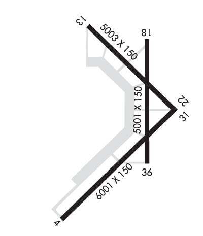
Runway Identifications
Runway Identification: 04/22Length: 6001 ft
Width: 150 ft
Surface: ASPHALT-GOOD CONDITION
Edge lights: Medium IntensityTreatment: NONE
| | Runway: 04 | | Runway: 22 |
| Mag heading: | 44° | Mag heading: | 224° |
| Rwy Slope: | -.10% Down | Rwy Slope: | .10% Up |
| Approach: | | Approach: | |
| Pattern: | Left Traffic | Pattern: | Left Traffic |
| Markings: | NONPRECISION INSTRUMENT | Markings: | NONPRECISION INSTRUMENT |
| Marking Condition: | GOOD | Marking Condition: | GOOD |
| Arresting Dev: | | Arresting Dev: | |
| Lat & Long: | N3606.8 W09056.0 | Lat. & Long.: | N3607.5 W09055.2 |
| Elev: | 279.1 ft. MSL | Elev: | 272.9 ft. MSL |
| TCH: | | TCH: | 47 ft. AGL |
| Visual Glide Path: | | Visual Glide Path: | 3.00 degrees |
| Displaced Threshold: | No | Displaced Threshold: | No |
| Touchdown Zone: | YES | Touchdown Zone: | YES |
| Touchdown Elev.: | 279.1 feet | Touchdown Elev.: | 273.6 feet |
| Visual Glide Slope: | | Visual Glide Slope: | 4-Light PAPI on LEFT side of Runway |
| RVR Equipment: | | RVR Equipment: | |
| RVV Equipment: | NO | RVV Equipment: | NO |
| Approach Lights: | MALSF - 1,400 foot medium intensity approach lighting system with sequenced flashers | Approach Lights: | |
| REIL: | NO | REIL: | NO |
| Centerline Lights: | NO | Centerline Lights: | NO |
| Touchdown lights: | NO | Touchdown lights: | NO |
| Runway Category: | Runway with a Visual Approach | Runway Category: | Runway with a Non-precision Approach having visibility minimums greater than 3/4 mile |
| Declared Distances: | | Declared Distances: | |
Runway Identification: 13/31Length: 5003 ft
Width: 150 ft
Surface: CONCRETE-FAIR CONDITION
Edge lights: Treatment: NONE
| | Runway: 13 | | Runway: 31 |
| Mag heading: | 134° | Mag heading: | 314° |
| Rwy Slope: | .01% Up | Rwy Slope: | -.01% Down |
| Approach: | | Approach: | |
| Pattern: | Left Traffic | Pattern: | Left Traffic |
| Markings: | BASIC | Markings: | BASIC |
| Marking Condition: | GOOD | Marking Condition: | GOOD |
| Arresting Dev: | | Arresting Dev: | |
| Lat & Long: | N3608.1 W09055.9 | Lat. & Long.: | N3607.5 W09055.2 |
| Elev: | 272.2 ft. MSL | Elev: | 272.8 ft. MSL |
| TCH: | | TCH: | |
| Visual Glide Path: | | Visual Glide Path: | |
| Displaced Threshold: | No | Displaced Threshold: | No |
| Touchdown Zone: | YES | Touchdown Zone: | YES |
| Touchdown Elev.: | 273.7 feet | Touchdown Elev.: | 274.4 feet |
| Visual Glide Slope: | | Visual Glide Slope: | |
| RVR Equipment: | | RVR Equipment: | |
| RVV Equipment: | NO | RVV Equipment: | NO |
| Approach Lights: | | Approach Lights: | |
| REIL: | NO | REIL: | NO |
| Centerline Lights: | NO | Centerline Lights: | NO |
| Touchdown lights: | NO | Touchdown lights: | NO |
| Runway Category: | Runway with a Visual Approach | Runway Category: | Runway with a Visual Approach |
| Declared Distances: | | Declared Distances: | |
| Obstructions: | ROAD | Obstructions: | BERM |
| Marked: | NOT Marked/Lighted | Marked: | NOT Marked/Lighted |
| Clearance slope: | 26:1 | Clearance slope: | 20:1 |
| Obstruction height: | 15 feet AGL | Obstruction height: | 1 feet AGL |
| Dist. from runway: | 600 feet | Dist. from runway: | 220 feet |
| Centerline offset: | | Centerline offset: | |
| Comments: | | Comments: | |
Runway Identification: 18/36Length: 5001 ft
Width: 150 ft
Surface: CONCRETE-FAIR CONDITION
Edge lights: Medium IntensityTreatment: NONE
| | Runway: 18 | | Runway: 36 |
| Mag heading: | 179° | Mag heading: | 359° |
| Rwy Slope: | -.02% Down | Rwy Slope: | .02% Up |
| Approach: | LOCALIZER | Approach: | |
| Pattern: | Left Traffic | Pattern: | Left Traffic |
| Markings: | PRECISION INSTRUMENT | Markings: | PRECISION INSTRUMENT |
| Marking Condition: | GOOD | Marking Condition: | GOOD |
| Arresting Dev: | | Arresting Dev: | |
| Lat & Long: | N3608.0 W09055.4 | Lat. & Long.: | N3607.1 W09055.4 |
| Elev: | 273.3 ft. MSL | Elev: | 272.2 ft. MSL |
| TCH: | | TCH: | |
| Visual Glide Path: | | Visual Glide Path: | |
| Displaced Threshold: | No | Displaced Threshold: | No |
| Touchdown Zone: | YES | Touchdown Zone: | YES |
| Touchdown Elev.: | 275.3 feet | Touchdown Elev.: | 274.0 feet |
| Visual Glide Slope: | | Visual Glide Slope: | |
| RVR Equipment: | | RVR Equipment: | |
| RVV Equipment: | NO | RVV Equipment: | NO |
| Approach Lights: | ODALS - omnidirectional approach lighting system | Approach Lights: | |
| REIL: | YES | REIL: | NO |
| Centerline Lights: | NO | Centerline Lights: | NO |
| Touchdown lights: | NO | Touchdown lights: | NO |
| Runway Category: | D | Runway Category: | Runway with a Non-precision Approach having visibility minimums greater than 3/4 mile |
| Declared Distances: | | Declared Distances: | |
| Obstructions: | ROAD | Obstructions: | |
| Marked: | NOT Marked/Lighted | Marked: | |
| Clearance slope: | 50:1 | Clearance slope: | 50:1 |
| Obstruction height: | 15 feet AGL | Obstruction height: | |
| Dist. from runway: | 1000 feet | Dist. from runway: | |
| Centerline offset: | | Centerline offset: | |
| Comments: | | Comments: | |

