Current Weather/Notams (Metars, TAFs, Notams, NWS Forecast, PIREPS, and nearby weather)
Customs Information Send updates to Support@FltPlan.com
Customs Not Available
Database effective 04/18/2024
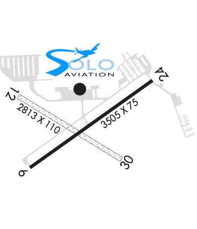
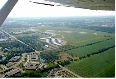
Airport Diagram might not be current. Facility Name: ANN ARBOR MUNI City Name: ANN ARBOR County: WASHTENAW State abbrev: MI State Name: MICHIGAN Ownership: PUBLICLY OWNED Use: OPEN TO THE PUBLIC Owner's Name: CITY OF ANN ARBOR Address: PO BOX 8647 ANN ARBOR, MI 48107-8647 Owner's Phone: 734-994-2841 Manager's Name: MATTHEW KULHANEK Address: 801 AIRPORT DR ANN ARBOR, MI 48108-9703 Phone: 734-994-9124 FAA Region: GREAT LAKES FAA Field Office: DET
Runway Identifications Help
Runway Identification: 06/24 Length: 3505 ftWidth: 75 ftSurface: CONCRETE-FAIR CONDITIONEdge lights: Medium Intensity Treatment: GROOVED Runway: 06 Runway: 24 Mag heading: 60° Mag heading: 240° Rwy Slope: -.15% Down Rwy Slope: .15% Up Approach: Approach: Pattern: Left Traffic Pattern: Left Traffic Markings: NONPRECISION INSTRUMENT Markings: NONPRECISION INSTRUMENT Marking Condition: GOOD Marking Condition: GOOD Arresting Dev: Arresting Dev: Lat & Long: N4213.2 W08345.0 Lat. & Long.: N4213.5 W08344.4 Elev: 831.3 ft. MSL Elev: 826.0 ft. MSL TCH: 20 ft. AGL TCH: 20 ft. AGL Visual Glide Path: 3.00 degrees Visual Glide Path: 3.00 degrees Displaced Threshold: No Displaced Threshold: No Touchdown Zone: YES Touchdown Zone: YES Touchdown Elev.: 831.3 feet Touchdown Elev.: 830.7 feet Visual Glide Slope: 4-Light PAPI on LEFT side of Runway Visual Glide Slope: 2-Box VASI on LEFT side of Runway RVR Equipment: RVR Equipment: RVV Equipment: NO RVV Equipment: NO Approach Lights: Approach Lights: REIL: YES REIL: NO Centerline Lights: NO Centerline Lights: NO Touchdown lights: NO Touchdown lights: NO Runway Category: Runway with a Non-precision Approach Runway Category: Runway with a Non-precision Approach Declared Distances: Declared Distances: Obstructions: Obstructions: ROAD Marked: Marked: NOT Marked/Lighted Clearance slope: 20:1 Clearance slope: 14:1 Obstruction height: Obstruction height: 59 feet AGL Dist. from runway: Dist. from runway: 1061 feet Centerline offset: Centerline offset: 344 feet right of centerline Comments: Comments:
Runway Identification: 12/30 Length: 2750 ftWidth: 110 ftSurface: GRASS-FAIR CONDITIONEdge lights: Treatment: NONE Runway: 12 Runway: 30 Mag heading: 127° Mag heading: 307° Rwy Slope: -.62% Down Rwy Slope: .62% Up Approach: Approach: Pattern: Left Traffic Pattern: Left Traffic Markings: Markings: Marking Condition: 3 FT YELLOW CONES. Marking Condition: 3 FT YELLOW CONES. Arresting Dev: Arresting Dev: Lat & Long: N4213.5 W08345.1 Lat. & Long.: N4213.2 W08344.6 Elev: 839.0 ft. MSL Elev: 822.0 ft. MSL TCH: TCH: Visual Glide Path: Visual Glide Path: Displaced Threshold: No Displaced Threshold: No Touchdown Zone: YES Touchdown Zone: YES Touchdown Elev.: 839.0 feet Touchdown Elev.: 839.0 feet Visual Glide Slope: Visual Glide Slope: RVR Equipment: RVR Equipment: RVV Equipment: NO RVV Equipment: NO Approach Lights: Approach Lights: REIL: NO REIL: NO Centerline Lights: NO Centerline Lights: NO Touchdown lights: NO Touchdown lights: NO Runway Category: Runway with a Visual Approach Runway Category: Runway with a Visual Approach Declared Distances: Declared Distances: Obstructions: TREE Obstructions: TREE Marked: NOT Marked/Lighted Marked: NOT Marked/Lighted Clearance slope: 16:1 Clearance slope: 15:1 Obstruction height: 44 feet AGL Obstruction height: 66 feet AGL Dist. from runway: 742 feet Dist. from runway: 1048 feet Centerline offset: 219 left of centerline Centerline offset: 248 feet right of centerline Comments: Comments: