Click here for more info on on SMS!

KARA

ACADIANA RGNL
NEW IBERIA
LA
Time Zone: Central
Lat: N 3002.3
Long: W 09153.0
Elev: 24
Var: -00
Longest Runway: 8002
Clr Del: 118.05/121.7
AWOS: 133.32
Ground: 121.7
Tower: 125.0

FBO & Flight Services info for KARA

FBOs: Update your Fuel Prices

FREEMAN JET CTRPh: 337-367-1401
-
Freq: 129.35
Service
Jet
100LL
SAF
MoGas
Fuel Avail: PRIST+ $0.11/gal. Tax Included. VOLUME DISCOUNTS APPLY
Full6.527.56    Last Update: 04/20/2024 14:02

Self        
 Address: 1314 HANGAR DR   NEW IBERIA LA 70560
ASOSPh: 337-365-0128
-
Freq: 133.32  
If you are an FBO, call 1-203-262-1700 to update your info or email: FltPlan.Advertising@garmin.com
Advertise your FBO on FltPlan.com

Runway & Approach Info for KARA
Rwy
Length
Land Dist**
Approach*
  Rwy
Length
Land Dist**
Approach*
17
8002x200  8002'          
 
  
35
  8002x200  8002'          
ILS/DME
 108.90 - 347°  
17W
5000x150  5000'          
 
  
35W
  5000x150  5000'          
 
 * only ILS, LOC, LDA, and SDF approaches to a specific runway are shown
** For any Declared Landing Distance Available, please see A/FD or Approach plates
Runway Weight Capability (lbs.) Help
Runway IDSingle WheelDouble WheelDouble Tandem WheelDual Double Wheel
17/35N/A105,000163,000400,000
17W/35WN/AN/AN/AN/A
These numbers are Advisory and are not limits.   The Airport Manager should have more accurate Weight Limits
Approach Charts
Approaches    
Current Weather/Notams
Customs Information Send updates to Support@FltPlan.com
Phone 985-632-8182
Fax N/A

Comments OPEN 0800 - 1600; M - F. 24H NOTICE REQUIRED FOR ARRIVALS.
Database effective 05/16/2024
Airport Diagram of KARA
Airport Diagram might not be current.

Facility Name: ACADIANA RGNL
City Name: NEW IBERIA
County: IBERIA
State abbrev: LA
State Name: LOUISIANA
   
Ownership: PUBLICLY OWNED
Use: OPEN TO THE PUBLIC
Owner's Name: IBERIA PARISH GOVERMENT
Address: 300 IBERIA ST
 NEW IBERIA, LA 70560
Owner's Phone: 337-365-8246
  
Manager's Name: MAURICE SONGY
Address: 1404 HANGAR DR
 NEW IBERIA, LA 70560
Phone: (337) 365-7202
   
FAA Region: SOUTHWEST
FAA Field Office: LNM
2006 Earthcrawl Photography www.earthcrawl.com


Click here for full scale & interactive Sectional view of KARA


Sunrise / Sunset times for ACADIANA RGNL

DateSunriseSunset
04/23/24 Tuesday6:3119:40
04/24/24 Wednesday6:3019:41
04/25/24 Thursday6:2919:42
04/26/24 Friday6:2919:42
04/27/24 Saturday6:2819:43
04/28/24 Sunday6:2719:44
04/29/24 Monday6:2619:44
04/30/24 Tuesday6:2519:45
05/01/24 Wednesday6:2419:46
05/02/24 Thursday6:2319:46
05/03/24 Friday6:2219:47
05/04/24 Saturday6:2119:47
05/05/24 Sunday6:2119:48
05/06/24 Monday6:2019:49

Airport Facilities

Airport Attendance Schedule7 Days A Week 0700-2100
Airport Status OPERATIONAL (This Status can change at any time - please check NOTAMS)
Airport Lighting ScheduleDUSK-DAWN. WHEN ATCT CLSD HIRL RWY 17/35 PRESET LOW INTST. TO INCR INTST - CTAF. MALSR RWY 35 ON CONSLY. ACTVT SEAWAY EDGE LGTS RWY 17W/35W - 122.7 3 CLICKS ON 7 CLICKS OFF.
Airport Storage AvailableTie Downs, Hanger
Extra Services AvailableAir Freight, Cargo Handling, Flight Instruction
Wind IndicatorYES - (lighted)
Control TowerYES
CTAF Frequency125.000
Unicom Frequency122.950
Rotating Beacon ColorWG
Segmented CircleYES
Landing FeeNO

Airport Inspection Data

Airport InspectedFEDERAL - performed by FAA AIRPORTS FIELD PERSONNEL
Inspection Date01/31/2024

Airport Services

Type of Fuel AvailableGrade 100LL, JET A (freeze point -40C); -10FOR FUEL AFT HRS CALL 337-367-1401 FAX 337-367-1404.
Airframe Repair ServiceMINOR
Power Plant Repair ServiceMINOR

Geographic Data

LatitudeN3002.3
LongitudeW09153.0 (ESTIMATED)
Arpt Elevation24ft (SURVEYED)
Magnetic Variation00E
4 miles NWof NEW IBERIA
Traffic Pattern Altitude
Sectional ChartHOUSTON

Aircraft Data

Operations (Reported)YearlyAvg. Daily
General Aviation Transient 1144631
General Aviation Local 2458167
Air Taxi 14004
Commerical 1110
Commuter 00
Military 20206
Aircraft based on Field
General Aviation Singles 41
General Aviation Multi 6
Jet Aircraft 5
General Aviation Helicopters 9
Military Aircraft 0
Gliders 0
Ultralights 0

FAA Services

FSS on field NO
FSS tie-in DE RIDDER
FSS Phone 1-800-WX-BRIEF
Who issues Notams ARA
Notam D service at airport YES
ARTCC Name HOUSTON

Federal Status

Airport CertificationPPR FOR MORE THAN 30 PSGR SEATS CALL AMGR 337-365-7202 (M-F 0830-1630).
Aircraft Rescue & Firefighting IndexAIRPORT HAS A CERTIFICATE UNDER CFR PART 139
Airport of EntryNo
Custom Landing RightsYES
Joint Civil/MilitaryNo
Military Landing rightsYES

Federal Agreements

NATIONAL PLAN OF INTEGRATED AIRPORT SYSTEMS (NPIAS)
GRANT AGREEMENTS UNDER FAAP/ADAP/AIP
SURPLUS PROPERTY AGREEMENT UNDER PUBLIC LAW 289
ASSURANCES PURSUANT TO TITLE VI, CIVIL RIGHTS ACT OF 1964
AGREEMENT UNDER DLAND OR DCLA HAS EXPIRED.

Remarks

THIS AIRPORT HAS BEEN SURVEYED BY THE NATIONAL GEODETIC SURVEY.
ROTOR WING MOVEMENT AND LANDING AREA BETWEEN THE RY AND SEAWAY.
INTENSIVE HELO TRAINING.
SEAPLANE LNDG AREA (WATER CHNL) W OF & ADJ/PARL TO RWY.
BIRD ACTIVITY ON & INVOF ARPT.
COMPASS ROSE NOT AVBL.
FOR CD WHEN APCH CLSD CTC HOUSTON ARTCC AT 281-230-5622.
ARFF INDEX B BTN 0200Z AND 1030Z MON THRU FRI.
RWY 17W/ 35WSEAWAY EDGE LGTS GREEN; THLD LGTS AMBER.
Airport Communications & Frequencies:
ACADIANA Tower Frequencies:   Hours(local) of operation: 0600-2100   
125.0
239.3
ACADIANA Ground Frequencies:
121.7
Clearance Delivery Frequencies:
118.05 WHEN TWR CLSD
121.7
Emergency Frequencies:
121.5
CTAF Frequency:
125.000
Unicom Frequency:
122.950
Remarks
  • APCH/DEP SVC PRVDD BY HOUSTON ARTCC (ZHU) ON FREQS 126.35/338.25 (LAFAYETTE RCAG) WHEN LAFAYETTE (LFT) APCH CTL CLSD.
  • LAFAYETTE Primary Approach Frequencies:  
    121.1
    268.7
    LAFAYETTE Primary Departure Frequencies:  
    121.1
    268.7
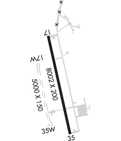
    Runway Identifications
    Runway Identification: 17/35
    Length: 8002 ft
    Width: 200 ft
    Surface: CONCRETE-GOOD CONDITION
    Edge lights: High Intensity

    Treatment: GROOVED
    Weight: PCN 39 /R/B/W/T

     Runway: 17   Runway: 35
    Mag heading: 168°Mag heading: 348°
    Rwy Slope: -.06% DownRwy Slope: .06% Up
    Approach: Approach: ILS/DME
    Pattern: Left TrafficPattern: Right Traffic
    Markings: PRECISION INSTRUMENTMarkings: PRECISION INSTRUMENT
    Marking Condition: GOODMarking Condition: GOOD
    Arresting Dev: Arresting Dev:
    Lat & Long: N3002.9  W09153.2Lat. & Long.: N3001.6  W09152.9
    Elev: 24.0 ft. MSLElev: 18.8 ft. MSL
    TCH: 51 ft. AGLTCH: 52 ft. AGL
    Visual Glide Path: 3.00 degreesVisual Glide Path: 3.00 degrees
    Displaced Threshold: NoDisplaced Threshold: No
    Touchdown Zone: YESTouchdown Zone: YES
    Touchdown Elev.: 24.0 feetTouchdown Elev.: 20.8 feet
    Visual Glide Slope: 4-Light PAPI on LEFT side of RunwayVisual Glide Slope: 4-Light PAPI on LEFT side of Runway
    RVR Equipment: RVR Equipment:
    RVV Equipment: NORVV Equipment: NO
    Approach Lights: ODALS - omnidirectional approach lighting systemApproach Lights: MALSR - 1,400 foot medium intensity approach lighting system with runway alignment indicator lights
    REIL: NOREIL: NO
    Centerline Lights: NOCenterline Lights: NO
    Touchdown lights: NOTouchdown lights: NO
    Runway Category: Runway with a Non-precision Approach having visibility minimums greater than 3/4 mileRunway Category: Precision Instrument Runway
    Declared Distances: TORA:8002' TODA:8002' ASDA:8002' LDA:8002'Declared Distances: TORA:8002' TODA:8002' ASDA:8002' LDA:8002'
    Runway Identification: 17W/35W
    Length: 5000 ft
    Width: 150 ft
    Surface: WATER
    Edge lights: Medium Intensity

    Treatment: NONE

     Runway: 17W   Runway: 35W
    Mag heading: 168°Mag heading: 348°
    Rwy Slope: .00% DownRwy Slope: .00% Up
    Approach: Approach:
    Pattern: Right TrafficPattern: Left Traffic
    Markings: NONSTANDARDMarkings: NONSTANDARD
    Marking Condition: Marking Condition:
    Arresting Dev: Arresting Dev:
    Lat & Long: N3002.5  W09153.4Lat. & Long.: N3001.7  W09153.2
    Elev: 20.3 ft. MSLElev: 20.2 ft. MSL
    TCH: TCH:
    Visual Glide Path: Visual Glide Path:
    Displaced Threshold: NoDisplaced Threshold: No
    Touchdown Zone: NOTouchdown Zone: NO
    Touchdown Elev.: Touchdown Elev.:
    Visual Glide Slope: Visual Glide Slope:
    RVR Equipment: RVR Equipment:
    RVV Equipment: NORVV Equipment: NO
    Approach Lights: Approach Lights:
    REIL: NOREIL: NO
    Centerline Lights: NOCenterline Lights: NO
    Touchdown lights: NOTouchdown lights: NO
    Runway Category: Runway with a Visual ApproachRunway Category: Runway with a Visual Approach
    Declared Distances: TORA:5000' TODA:5000' ASDA:5000' LDA:5000'Declared Distances: TORA:5000' TODA:5000' ASDA:5000' LDA:5000'
    C:14/P: