Current Weather/Notams (Metars, TAFs, Notams, NWS Forecast, PIREPS, and nearby weather)
Customs Information Send updates to Support@FltPlan.com
Customs Not Available
Database effective 04/18/2024
Airport Diagram might not be current.
|
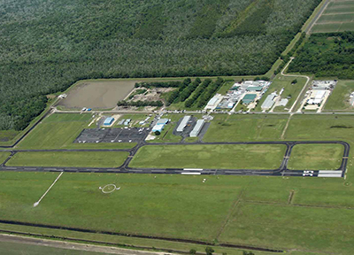
| Facility Name: | PORT OF SOUTH LOUISIANA EXEC RGNL |
| City Name: | RESERVE |
| County: | ST JOHN THE BAPTIST |
| State abbrev: | LA |
| State Name: | LOUISIANA |
| | |
| Ownership: | PUBLICLY OWNED |
| Use: | OPEN TO THE PUBLIC |
| Owner's Name: | PORT OF SOUTH LOUISIANA EXECUTIVE |
| Address: | 171 BELLE TERRE |
| | LAPLACE, LA 70068 |
| Owner's Phone: | 985-652-9278; FBO CTR 985-652-9278 #8512 OR 8510. |
| | |
| Manager's Name: | CHARLES PALMER |
| Address: | 355 AIRPORT ROAD; AIRPORT PHYS. ADDRESS: 355 AIRPORT RD., RESERVE, LA 70084 |
| | RESERVE, LA 70084 |
| Phone: | 985-212-1712; AFT HRS - (985) 212-1712 OR 985-652-9278 EXT 1121 |
| | |
| FAA Region: | SOUTHWEST |
| FAA Field Office: | LNM |
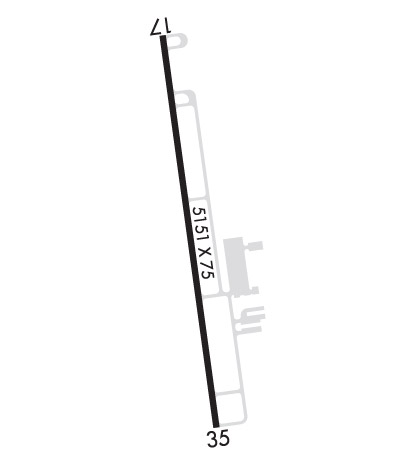
Runway Identifications
Runway Identification: 17/35Length: 5151 ft
Width: 75 ft
Surface: ASPHALT
Edge lights: Medium IntensityTreatment: NONE
| | Runway: 17 | | Runway: 35 |
| Mag heading: | 173° | Mag heading: | 353° |
| Rwy Slope: | .07% Up | Rwy Slope: | -.07% Down |
| Approach: | | Approach: | |
| Pattern: | Left Traffic | Pattern: | Right Traffic |
| Markings: | NONPRECISION INSTRUMENT | Markings: | NONPRECISION INSTRUMENT |
| Marking Condition: | GOOD | Marking Condition: | GOOD |
| Arresting Dev: | | Arresting Dev: | |
| Lat & Long: | N3005.7 W09035.0 | Lat. & Long.: | N3004.8 W09034.9 |
| Elev: | 3.1 ft. MSL | Elev: | 6.5 ft. MSL |
| TCH: | 50 ft. AGL | TCH: | 50 ft. AGL |
| Visual Glide Path: | 3.00 degrees | Visual Glide Path: | 3.00 degrees |
| Displaced Threshold: | 746 feet | Displaced Threshold: | No |
| Touchdown Zone: | YES | Touchdown Zone: | YES |
| Touchdown Elev.: | 5.7 feet | Touchdown Elev.: | 6.5 feet |
| Visual Glide Slope: | 2-Light PAPI on LEFT side of Runway | Visual Glide Slope: | 2-Light PAPI on LEFT side of Runway |
| RVR Equipment: | | RVR Equipment: | |
| RVV Equipment: | NO | RVV Equipment: | NO |
| Approach Lights: | | Approach Lights: | |
| REIL: | YES | REIL: | YES; RWY 35 LEFT REIL OTS |
| Centerline Lights: | NO | Centerline Lights: | NO |
| Touchdown lights: | NO | Touchdown lights: | NO |
| Runway Category: | Runway with a Non-precision Approach | Runway Category: | Runway with a Non-precision Approach |
| Declared Distances: | | Declared Distances: | |
| Obstructions: | TREES | Obstructions: | |
| Marked: | NOT Marked/Lighted | Marked: | |
| Clearance slope: | 20:1; APCH SLOPE 22:1 TO THE DSPLCD THLD. | Clearance slope: | 34:1 |
| Obstruction height: | 75 feet AGL | Obstruction height: | |
| Dist. from runway: | 1725 feet | Dist. from runway: | |
| Centerline offset: | | Centerline offset: | |
| Comments: | | Comments: | |